
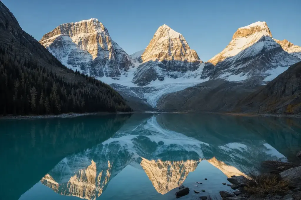
Shavlo Lakes are a series of high-mountain basins strung along the Shavla River in the North-Chuya Ridge, part of the Altai Mountains in southern Siberia. Located at roughly 2,000 metres elevation, the lakes are fed by Shavlo Glacier and surrounded by dense larch and pine forest. The water transforms from grey-white glacial sediment in early summer to brilliant turquoise by August.
The lakes consist of three main bodies: Lower (also called Nizhny), Middle and Upper Shavlo, each with distinct character. Three named peaks—Skazka (Fairy Tale), Krasavitsa (Beautiful) and Mechta (Dream)—rise behind the lakes and reflect in the water. Streams flowing from these peaks and moraines create a dramatic landscape that has made Shavlo Lakes one of the most photographed destinations in the Altai Mountains.
Quick Facts
| Russian name | Озёра Шавло |
|---|---|
| Built / opened | 1924 |
| Address | North-Chuya Ridge, Altai Mountains, Altai Republic Google MapsApple MapsYandex Maps2GIS |
| District | Altai Republic |
| Admission | free |
| Best time to visit | July, August and early September are the optimal months. By mid-July, snow has melted from most of the trail and lakes, and streams are passable. August offers stable weather, warm days and clear views of the peaks. September can be beautiful, with golden larch trees and fewer visitors, but weather becomes unpredictable and first snow can fall at altitude. June can have lingering snow and swollen rivers; October onwards brings winter snow and is suitable only for mountaineers. Weekdays are quieter than weekends. |
| Recommended duration | 2–4 days |
What Is (and Isn't) Part of a Visit to Shavlo Lakes, Altai Mountains?
| Part | Status | Notes |
|---|---|---|
| Lower Shavlo Lake (Nizhny Shavlinsky) | Included in the standard ticket | The lowest main lake, roughly 10 km from the road trailhead, accessible as a two-day hike. |
| Middle Shavlo Lake (Srednyaya Shavlinsky) | Included in the standard ticket | The central and most visited lake, the primary destination for most trekkers; another 5–6 hours' hike from Lower Lake. |
| Upper Shavlo Lake (Verkhnaya Shavlinsky) | Included in the standard ticket | The highest main lake at tree line, accessible as a day trip from Middle Lake. |
| Small alpine lakes above Upper Shavlo | Included in the standard ticket | A network of smaller unnamed lakes near Shavlo Glacier, accessible on foot from Upper Lake but requiring mountaineering skill to reach safely. |
| Shavlo Glacier | Included in the standard ticket | Visible from Upper Shavlo Lake; approaching or climbing requires mountaineering experience and is not recommended without a guide. |
| Closest town (Gorno-Altaysk or Chemal) | Outside / not part of it | The nearest road access is near Chemal village; from there, a 4–5 hour drive and then the hike to Lower Lake begins. Accommodation and supplies must be arranged in advance. |
Why Visit Shavlo Lakes, Altai Mountains?
Shavlo Lakes attract mountain trekkers for their combination of accessible high-altitude scenery and pristine alpine landscape. The Middle Lake is the most popular: the largest and most picturesque of the three, surrounded by larch forest on one shore and rocky scree on the other, with clear views of the glacier-draped peaks.
The lakes lie within reach of the upper Altai plateau system, making them a base for multi-day hikes and mountaineering. Summer visitors will find the water stable enough for exploration, and the mountains are snow-free above the tree line. The site is popular for camping and radial day trips up the valleys to smaller alpine lakes near the glacier itself.
Highlights of Shavlo Lakes, Altai Mountains
Lower Shavlo Lake (Nizhny)
The lowest and largest of the three main lakes, at approximately 1,983 metres elevation. Its water collects glacial melt from the moraines and takes on a cloudy grey or milky turquoise hue depending on the season. The lake is surrounded by rocky scree on the left bank and mixed Siberian pine and larch forest on the right. Local tradition holds that visitors stack wooden idols on the shore.
Tip: This lake fills with snowmelt runoff early in summer, so water colour and clarity peak in August and September. The 10 km hike from the road to this lake typically takes 5–6 hours.
Middle Shavlo Lake (Srednyaya)
The main destination for most trekkers, located at 1,938 metres and regarded as the most photogenic. It is the largest and sits in a classic glacial valley, surrounded by dense larch forest. The western shore has a well-established trail and camping areas. The three named peaks—Skazka, Krasavitsa and Mechta—mirror perfectly in the water, a view framed by dark forest.
Tip: Most hiking parties establish a base camp on the western shore to make day trips. The Middle Lake is roughly 5–6 hours' walk from Lower Shavlo, making it a two-day approach from the trailhead.
Upper Shavlo Lake (Verkhnaya)
Located at 2,164 metres, this is the highest of the main lakes and sits in bare alpine landscape just above the tree line. It sits near the snout of Shavlo Glacier. The views here are bleaker and more stark than the lower lakes—high mountain slopes and scree without forest, and the glacier and its meltwater streams directly visible.
Tip: A one-day radial hike (4–5 hours round trip) from Middle Lake reaches Upper Shavlo and continues to smaller unnamed alpine lakes within sight of the glacier itself. Pack water and sun protection.
Shavlo Glacier
The stream-feeding feature of the lake system, a moderate-sized glacier descending from the North-Chuya Ridge. Glacial melt creates the Shavla River, which flows downward through all three lakes. The glacier is visible from Upper Shavlo Lake and can be approached on foot, but climbing or crossing requires mountaineering experience.
Tip: The glacier forms moraines (rock ridges) that trap water into the lakes below. Visitors can view it from Upper Shavlo without climbing gear. Do not venture onto the glacier ice itself without a guide and rope.
Three Named Peaks
Skazka (2,690 m), Krasavitsa (3,800 m) and Mechta (2,900 m) are three distinctive peaks of the North-Chuya Ridge that overlook the lakes. The Russian mathematician and mountaineer Boris Delone named them in the 1920s. Krasavitsa is the highest peak of the three and was named for its beauty. Their reflections in the Middle Lake create the classic postcard image.
Tip: The peaks are often snow-covered into July. Early September offers the clearest views and most reliable weather. Bring a polarising filter if photographing reflections; the turquoise water creates strong glare.
Shavla River Valley Trail
The approach route follows the Shavla River valley from the parking area near the village of Chemal. The lower section passes through dense taiga forest, wetlands and mountain streams. The terrain is mostly trail but becomes steeper as altitude increases. The valley narrows where the river cuts through rocky gorges.
Tip: Early in summer (June–early July), sections of the trail can be boggy and streams swollen from melt. July–September is more reliable. Bring water-resistant boots and gaiters. Stream crossings are usually fordable but can be swift.
Atmosphere
The lakes occupy a high mountain basin ringed by taiga forest below and bare rock and scree above the tree line. The air is cool and thin at altitude; mornings are often misty, with cloud clearing to strong sun by midday. The sound of water is constant—glacier melt flowing downslope into streams and the river below.
The Middle Lake is the most frequented, with a scattering of tents on the western shore, especially in July and August. The atmosphere is one of rugged self-sufficiency; visitors are typically experienced backpackers carrying tents and food. Early morning light transforms the turquoise water and glacier peaks into an almost unreal clarity. By afternoon, weather systems can roll in quickly, bringing wind and sometimes rain or snow.
History of Shavlo Lakes, Altai Mountains
The first documented exploration of Shavlo Lakes came in 1924, when Russian climbers Mikhail and Boris Tronov reached them. They were followed by mathematician, physicist and mountaineer Boris Delone, who travelled to the lakes and named the three prominent peaks. Delone recorded his impressions, noting that the peaks and their reflections created a natural work of art.
The name ‘Shavla’ comes from the Altai language and means ‘young tree’, likely referring to the larch forests that surround the lower lakes. The Shavla River that feeds and drains the lake system has been known to local hunters and herders in the Altai for centuries, but the high alpine lakes themselves remained isolated and little visited until improved mountain access in the Soviet era.
Today Shavlo Lakes are part of the broader Altai Mountains protected landscape, within the range of Altai Republic nature reserves and parks. Access is not formally restricted, but the remote location and multi-day hiking requirement ensure that visitor numbers remain low compared to other Altai destinations. The site remains a destination for mountaineers, trekkers and photographers rather than casual tourists.
Legends and Myths about Shavlo Lakes, Altai Mountains
The Three Sisters of the Ridge
Legend – historically unreliable. Local Altai tradition holds that the three named peaks—Skazka, Krasavitsa and Mechta—represent three sisters: Fairy Tale, Beauty and Dream. According to one telling, they are bound to the mountain by an ancient enchantment and can only be seen clearly by those with a pure heart. Their perfect reflection in the Middle Lake was said to be a sign of their blessing.
Boris Delone's Vision
Legend – historically unreliable. Mountaineer Boris Delone is said to have been so moved by the beauty of Shavlo that he wept when he first saw the three peaks and their reflections. He recorded in his diary that the landscape was 'a work of art nature had created with its own hands'. Some trekkers claim that spending a night by the lakes brings clarity to one's thoughts, as if Delone's sense of wonder is contagious.
Tickets and Booking for Shavlo Lakes, Altai Mountains
There is no admission fee or permit system for visiting Shavlo Lakes. However, visitors should be aware that the Altai region is within Russia’s protected landscape system, and some areas of the broader Altai Mountains reserve system do restrict access or require permits. The Shavlo Lakes themselves are accessible to independent trekkers.
Practical access: Most visitors hire a driver or use public transport to reach the road terminus near Chemal village, or arrange a local guide through outfitters in Gorno-Altaysk. From there, the trek to Lower Lake takes 2 days on foot. Accommodation at the lakes is camping only; bring a tent. No supplies, huts or services exist on site. Food, water and all equipment must be carried in.
Weather and seasonal access: The lakes are snow-free and accessible July through mid-September. Earlier seasons (June) can have snow at higher elevations and swollen streams. October and later bring snow and single-digit temperatures. Winter access is possible only with mountaineering experience and equipment.
Plan and Book
Suggested itineraries Shavlo Lakes, Altai Mountains
2 days
Day 1: Drive or taxi from Gorno-Altaysk to Chemal or the road trailhead (4–5 hours). Hike 10 km to Lower Shavlo Lake (5–6 hours), following the Shavla River valley through taiga forest. Arrive midday or late afternoon; camp on shore. Day 2: Hike to Middle Shavlo Lake (5–6 hours). Explore Middle Lake, camp, and return the next day.
3–4 days
Day 1: Road to Chemal trailhead, hike to Lower Lake (as above). Day 2: Hike to Middle Lake (5–6 hours). Day 3: Day trip from Middle Lake to Upper Lake and back (4–5 hours round trip) or to small alpine lakes near glacier. Day 4: Hike back to Lower Lake and road (can be done in one long day if needed).
5–7 days
Days 1–2: As above to Middle Lake. Days 3–4: Establish base camp at Middle Lake. Make radial day trips: one day to Upper Lake and small alpine lakes (4–5 hours), another to higher valleys or meadow areas (full day). Day 5: Optional climb to nearby ridge viewpoint or glacial viewpoint. Days 6–7: Return to road in stages.
How to Get to Shavlo Lakes, Altai Mountains
By air and road: Fly to Gorno-Altaysk (the regional capital of Altai Republic). From the airport, arrange a taxi, rental car or join an organised tour. The drive to the Shavla River trailhead near Chemal village takes 4–5 hours. Many visitors hire a local driver; English-speaking guides and drivers can be arranged through hotels and tour companies in Gorno-Altaysk.
Trailhead access: The road ends near the village of Chemal. From there, the trek to Lower Shavlo Lake starts, following the Shavla River valley. The first section passes through inhabited areas and farmland, then transitions to dense taiga forest and mountain terrain. There is no public transport on the trail itself; visitors trek on foot.
Alternatives: Some tour operators and adventure companies in Gorno-Altaysk or Belgorod offer multi-day guided treks to the lakes, including transport, guide services, meals and camping equipment. These typically cost significantly more than independent travel but handle logistics and reduce navigation risk.
Accessibility
Shavlo Lakes are not wheelchair-accessible. The approach requires a full 2–4 day backpacking trek at high altitude with steep terrain, stream crossings and significant elevation gain. The 10 km hike to Lower Lake alone covers rough mountain trails with limited facilities. Visitors must be physically fit for multi-day mountain hiking. There are no toilets, shelters or accessible infrastructure on site—camping is the only option. Solo visitors should be experienced; travelling with a guide or group is recommended for safety.
Food Nearby
No food or supplies are available at the lakes themselves. Gorno-Altaysk and Chemal have supermarkets, markets and restaurants where supplies can be purchased before departure. All food for the trek must be purchased and packed in advance. Visitors typically bring dried meals, energy bars, nuts and portable cooking fuel. Fresh water is available from streams and lakes but should be treated or boiled before drinking.
What to Bring
Bring a 4-season tent capable of handling wind and unexpected snow at altitude. Sleep in a rated sleeping bag (summer-weight for July–August, warmer for shoulder seasons). Layers are essential: temperatures drop below freezing at night even in summer. Waterproof rain gear, sturdy hiking boots with gaiters, sun protection (hat, high-SPF sunscreen), insect repellent for the lower forest sections, and a headlamp are essential. Carry a map, compass or GPS device, and tell someone your route and expected return date. Do not bring drones; photography with standard camera equipment is permitted.
Best Views and Photo Spots of Shavlo Lakes, Altai Mountains
Western shore of Middle Lake, late afternoon
The classic view: three glacier peaks directly reflected in turquoise water, with dark larch forest as a frame. Light is warm and golden, peaks are sharply defined, and shadows define the relief.
Best time: 4–6 p.m., mid-August when water clarity peaks and weather is stable. Earlier seasons (June–early July) have greyish water from glacial silt.
Rocky scree on left (eastern) bank of Middle Lake
Foreground of orange and grey boulders with lake and peaks beyond. Offers depth and texture that shoreline shots lack. Early morning light illuminates the rocks while peaks remain in cool shadow.
Best time: 6–8 a.m., especially in clear weather. Cloud often moves in by midday.
Upper Shavlo Lake shore, north side, looking at glacier
Close view of Shavlo Glacier snout and bare rock slopes without forest clutter. Lower Lake and Lower Shavlo Peak visible in the valley far below, showing the full elevation span.
Best time: Morning light (6–9 a.m.) when glacier is bright and shadows define crevasses. Visit in late August for maximum glacier visibility.
Lower Shavlo Lake outlet where river begins
Dramatic view of the outlet stream cascading over moraine, with Lower Lake beyond and rocky peaks above. Conveys the water's journey and landscape drama.
Best time: Mid-morning light. High water (June–early July) makes the cascade more dramatic but obscures reflection.
Photography Rules
Photography is permitted throughout Shavlo Lakes. The turquoise water and glacier peaks create striking images, especially at sunrise and sunset when light is soft and shadows define the peaks. Avoid drones and large tripods that may disturb other trekkers. Bring a polarising filter to reduce glare from the water. The light is intense at altitude; fast film speeds are not necessary. Late-day light (after 4 p.m.) creates the clearest reflections in Middle Lake.
Family Suitability
Shavlo Lakes are not suitable for young children or families with toddlers. The 2–4 day trek requires carrying all gear and supplies, crossing streams, and navigating steep terrain. The nearest accommodation is camping at altitude in exposed terrain. Children aged 12+ with hiking experience and proper equipment could potentially attempt the Middle Lake (the lowest 5,000+ feet trek), but younger children lack the endurance and the conditions are potentially dangerous without close supervision. Strollers and wheeled gear cannot be used on any section of the trail.
Russia Vibes Tips
- Acclimatise to altitude gradually. The lower trailhead is around 600 metres; Middle Lake sits at 1,938 metres. Spend a night at a lower camp before pushing to higher lakes to reduce altitude sickness risk.
- Book guides or drivers through established Gorno-Altaysk tour companies rather than accepting offers from random individuals at the airport. Reputable operators handle permits (if required), provide reliable transport and know current trail conditions.
- Bring water treatment tablets or a portable filter. Streams can carry giardia and other parasites. Boiling water takes time and fuel; chemical treatment is faster and lighter.
- The Middle Lake is far more visually rewarding than the Lower Lake. Do not skip the extra 5–6 hour hike; the treeless alpine basin and perfect peak reflections make it worth the effort.
- Start early each hiking day (5–6 a.m.). Mountain weather deteriorates by early afternoon. An early finish ensures time to set camp, collect water and explore before dark.
- Do not drink directly from lakes or streams. In July especially, glacial sediment can cause mild gastric upset. Filtered or boiled water reduces this risk significantly.
Explore Nearby Shavlo Lakes, Altai Mountains
Sights near Shavlo Lakes, Altai Mountains
 Chersky Stone, Lake Baikalabout 1,231.1 km away · typical visit: 2–3 hours
Main image: AI-generated illustration. It may not show the place exactly as it looks.
Related guides
 Altai Mountains: Best Places, Scenic Routes and Travel Tips
Main image: AI-generated illustration. It may not show the place exactly as it looks.
 Chuya and Katun Confluence: Free Viewpoint and Sacred Altai LandmarkOpen 24 hours
Main image: AI-generated illustration. It may not show the place exactly as it looks.
 Uchar Waterfall: Hiking to Russia’s Most Remote Cascade
Main image: AI-generated illustration. It may not show the place exactly as it looks.
 Ukok Plateau: Remote Expedition Across Ancient Steppe
Main image: AI-generated illustration. It may not show the place exactly as it looks.
 Akkem Lake: Alpine Trek to Mount Belukha’s Base
Main image: AI-generated illustration. It may not show the place exactly as it looks.
Browse more: More in Altai Republic · All Altai Mountains · All Parks · All Sightseeing · All Sightseeing in Altai Mountains
FAQ: Shavlo Lakes, Altai Mountains
How long does it take to reach Shavlo Lakes from Gorno-Altaysk?
Plan a full day. The drive from Gorno-Altaysk to the Chemal trailhead takes 4–5 hours. From the road, a 2-day trek is required to reach Lower Lake (10 km, 5–6 hours' hiking each day), then another 5–6 hours to Middle Lake. Most visitors plan to arrive at Middle Lake on day 3.
Do I need a permit or guide to visit Shavlo Lakes?
No permit is required for independent trekking. However, hiring a guide through a licensed tour operator is recommended for navigation, safety and local knowledge. Guides cost extra but provide valuable support, especially for first-time visitors.
What is the best month to visit?
August is ideal: snow has melted, water is clear, weather is relatively stable and temperatures are warm. July is also good but has higher water flow and greyish glacial sediment. September offers golden larch colours and fewer crowds, but weather is less predictable.
Can I hike to Shavlo Lakes in winter?
Winter access is possible only for experienced mountaineers with appropriate gear (ice axes, crampons, avalanche safety equipment). Snow can be deep, avalanche risk is real, and conditions change rapidly. Most visitors avoid winter.
Is the Middle Lake worth reaching, or is Lower Lake sufficient?
The Middle Lake is significantly more beautiful and is the primary destination for most visitors. It is larger, set in a classic glacial basin with perfect peak reflections, and surrounded by larch forest. An extra 5–6 hours' hike from Lower Lake, it is well worth the effort.
What should I do if bad weather strikes while I am on the trail?
Seek shelter immediately. Set up your tent and stay put until weather clears. Do not attempt steep sections or river crossings in high winds or heavy rain. Hypothermia can develop quickly at altitude even in summer. Carry emergency supplies and inform someone of your planned route before departure.
Can I reach the Shavlo Glacier on foot?
Yes, you can hike to viewpoints of Shavlo Glacier from Upper Lake without climbing equipment. Do not venture onto the glacier ice itself without a guide and mountaineering gear; crevasses are hidden under snow and ice is unstable.
Are there any small restaurants or shops near the lakes?
No. The lakes are in remote mountain terrain. All food, water treatment, fuel and supplies must be carried from Gorno-Altaysk or Chemal. Resupply on the trail is impossible.
Russia Vibes is a one-person project. A coffee keeps it going
How we research and update our guides
About this guide: AI assistance and accuracy
This guide is created with the help of AI and is based on official sources where available. Mistakes can still happen. Opening hours, prices, rules and other details are given to the best of our knowledge as of the date shown and can change without notice. It offers general recommendations only, not professional, legal or travel advice. Please confirm important details with the official source before you travel; you are responsible for your own plans and decisions.
Packing for this trip
* Affiliate link: as an Amazon Associate we earn from qualifying purchases at no extra cost to you.

Take this guide with you
Get a free PDF of this guide to print or read offline: key facts, tips and a map link on a few clean pages.
Report an issue on this page
Paying for your trip: please read
International sanctions affect payments between Russia and many other countries. In practice, cards issued in the EU, the UK, the US and several other countries often do not work in Russia, Russian cards usually do not work abroad, and some booking platforms, airlines and payment providers limit or suspend their services for Russia. The situation changes frequently.
We do not give legal or financial advice, and this site does not encourage anyone to break or circumvent sanctions. Whatever you plan, you are responsible for following the laws and regulations that apply to you, including those of your country of residence and citizenship.
Many travelers still organise their stay lawfully. It is worth asking your bank or payment provider what is currently permitted, contacting hotels, tour operators and carriers directly about the payment methods they accept, and checking which services are open to customers from your country. Clarify payment, cancellation and refund terms before you commit to a booking, and keep your plans flexible.
Partner links on this site may not be available in every country, and prices, availability and rules in our guides can differ from what you see when you book.