
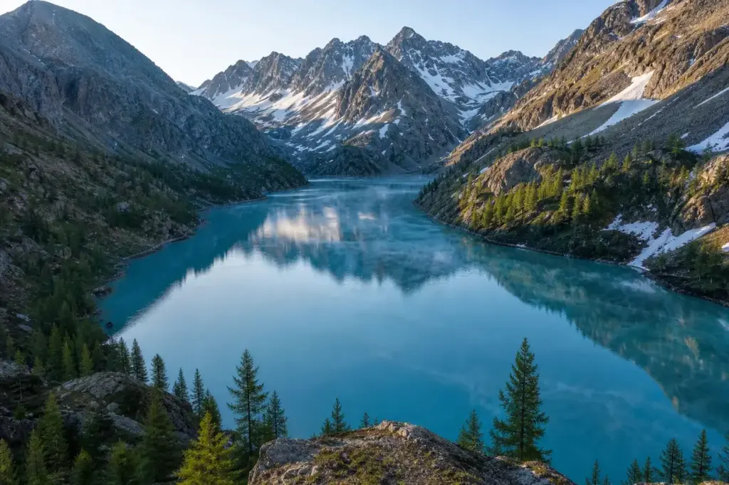
Kucherla Lake is a high-altitude glacial lake in the central Altai Mountains, the gateway for trekkers approaching Mount Belukha. Located within the Katun Nature Reserve, the lake sits at 1,790 metres above sea level and covers about 3 square kilometres. It is surrounded by alpine meadows and peaks over 3,000 metres high. The water carries a distinctive turquoise colour from glacial melt, visible across the surrounding larch forests.
Together with Belukha Mountain, Lake Teletskoye and the Ukok Plateau, Kucherla Lake forms part of the UNESCO World Heritage site entitled the Golden Mountains of Altai. The lake marks the point where most Belukha trekking routes begin their ascent toward higher passes and the mountain itself.
Quick Facts
| Russian name | Кучерлинское озеро |
|---|---|
| Address | Ust-Koksinsky District, Altai Republic Google MapsApple MapsYandex Maps2GIS |
| District | Ust-Koksinsky |
| Best time to visit | Summer (July to August): The only practical trekking season. Snow clears from lower elevations by late June, and passes are accessible. Weather is most stable in July and August, though afternoon thunderstorms are common.Early season (late June): Snow may linger on higher passes; confirm conditions before attempting Kara-Tyurek Pass.Shoulder season (September): Possible but water crossings become more difficult as glacial melt increases rivers. Larch trees begin turning gold in September, offering scenic reward.Winter to spring: The lake and all approaches are buried under deep snow and ice; inaccessible without specialised alpine mountaineering skills and equipment. |
| Recommended duration | 4–7 days trekking |
What Is (and Isn't) Part of a Visit to Kucherla Lake, Altai Mountains?
| Part | Status | Notes |
|---|---|---|
| Lake Kucherla itself and shoreline camping | Included in the standard ticket | Free access to the lake and permitted camping on designated sites at the shoreline; part of protected area requiring trekking permits (see booking_info). |
| Kucherla River valley trail from Tungur | Included in the standard ticket | The hiking route along the Kucherla River leading to the lake is part of the main approach; approximately 32 km with 1,180 metres elevation gain. |
| Kara-Tyurek Pass route from lake to Akkem Valley | Included in the standard ticket | The continuation trek from Lake Kucherla toward Belukha passes through this high pass; includes overnight camping on the route. |
| Mount Belukha summit climb | Separate ticket or institution | Climbing the actual peak requires mountaineering skills, specialised permits, and guided ascent; the lake provides access to base camp approaches only. |
| Katun Nature Reserve protection | Included in the standard ticket | The lake is within the Katun Nature Reserve; permits and guides are required for independent trekking in this protected zone. |
| Akkem Lake and valley | Outside / not part of it | Akkem Lake lies across the Kara-Tyurek Pass to the east; it is a separate destination requiring additional days of trekking. |
Why Visit Kucherla Lake, Altai Mountains?
Kucherla Lake is the starting point for multi-day mountain treks to Mount Belukha and across the high Altai passes. It is a remarkable glacial lake commonly included in multi-day trekking journeys through the central Altai, surrounded by steep forested and alpine slopes. The trek from Kucherla Village to the lake covers 32 kilometres with a 1,180-metre elevation gain, while from the lake a well-maintained trail leads to the Kara-Tyurek Pass at 3,085 metres. The lake itself offers camping, fishing and day hiking along its shores, with views toward glacier-fed peaks and the opportunity to explore pristine alpine terrain in one of Asia’s most remote wilderness areas.
Highlights of Kucherla Lake, Altai Mountains
The lake shore and turquoise water
The lake sits among steep rocky slopes and open alpine grasslands, with water that has a milky blue colour caused by fine particles carried down from the glaciers above. The lake is surrounded by larch trees at 1,790 metres elevation. The shoreline offers several camping areas and vantage points for viewing the surrounding peaks. Look for the most vivid colour in early summer when glacial melt is heaviest.
Tip: Camp on the northern shore for unobstructed views of the peaks reflected in the water at dawn.
Alpine meadows and wildflowers
The lake is surrounded by alpine meadows and peaks over 3,000 metres high. In summer months, these slopes fill with mountain flowers and alpine grasses. The meadows provide good day-hiking terrain and are home to mountain goats and other wildlife. The terrain is relatively open, making navigation straightforward.
Tip: The meadows are most colourful in July and August; visit after late June when snow has cleared.
Kara-Tyurek Pass approach
A well-maintained trail leads from Lake Kucherla to the Kara-Tyurek Pass at an elevation of 3,085 metres. This high pass connects the Kucherla Valley to the Akkem Valley and Mount Belukha's base camp. The ascent crosses talus slopes and alpine terrain with views across multiple valleys. Most trekkers take this route as the next leg after the lake.
Tip: The pass often holds snow into July; confirm conditions with local guides before attempting in early season.
Kucherla River valley on approach
The scenic trail from Kucherla Village runs along the Kucherla River. The path gradually rises above the forest area and opens onto a high-altitude plateau, with views of the Kucherla River valley, Lake Kucherlinsky and the snow-capped peaks of the Katun Ridge. The river itself has turquoise-coloured water and flows through cedar and larch forest.
Tip: The village of Tungur, not Kucherla Village, is the main trekking trailhead; Kucherla Village is only a small settlement further up the valley.
Fishing opportunities
The waters of the Ak-kem and Kucherla Lakes are called the 'dead' and 'alive' respectively, and there is a lot of fish in Kucherla. The lake supports trout and other cold-water species suitable for fly and spin fishing. Fishing requires no permit beyond Russian national fishing regulations.
Tip: Bring lightweight fishing tackle; the lake's cold water makes early morning fishing most productive.
Mount Belukha views
The Kucherla river system's northern valleys descend toward Belukha Mountain. While the summit is not visible from the lake itself, the surrounding high peaks offer dramatic views. Mount Belukha is the highest peak in the Altai Mountains at 4,506 metres. Most trekkers use the lake as a staging point before ascending to higher elevations where the mountain becomes fully visible.
Tip: For the best Belukha views, ascend toward Kara-Tyurek Pass or continue to Akkem Lake; these vantage points provide unobstructed panoramas.
Atmosphere
Kucherla Lake is a big and beautiful lake located at 1,790 metres elevation, surrounded by larch trees. The air is thin and cool year-round, with summer temperatures ranging from cool mornings to pleasant midday conditions. There are few camping places in front of the lake, and morning fog often stretches above the water surface. The landscape is quiet and remote, with few visitors outside the main trekking season. Sound carries across the water; distant waterfalls and wind in the larches form the main ambient sounds. Early morning brings mist rising from the glacial water, while afternoons can suddenly cloud over as weather moves through the passes above.
History of Kucherla Lake, Altai Mountains
The lake formed at the end of the last ice age as glaciers melted and filled the rocky basins they had carved out over centuries. The basin of the lake was formed by ancient glacier movement. Kucherla Lake has been a traditional route through the Altai for centuries, used by nomadic herders and traders connecting the valleys. Modern trekking to the lake became established in the 20th century as mountaineers began ascending Belukha.
The area remains relatively undeveloped, with access primarily on foot or horseback. The lake and surrounding valleys fall within protected territory designated as part of the Katun Nature Reserve. The region’s remote location has preserved the landscape largely unchanged, though trekking routes and campsites have become more established as tourism has slowly increased.
Legends and Myths about Kucherla Lake, Altai Mountains
The 'Alive' and 'Dead' Lakes
Legend – historically unreliable. Kucherla Lake is called the 'Upper Kucherla' and the waters of the Akkem and Kucherla Lakes are known as the 'dead' and 'alive' respectively. The names refer to the visual appearance: Akkem Lake appears grey and turbid from glacial powder, while Kucherla's water is emerald-green and clear, appearing 'alive'. Local guides attribute spiritual significance to this distinction.
Tickets and Booking for Kucherla Lake, Altai Mountains
Kucherla Lake lies within the Katun Nature Reserve, a protected area requiring permits and typically a guide. Book treks through established tour operators that handle permits, logistics and camping arrangements. Russian tour companies based in nearby Barnaul or in Irkutsk arrange most Belukha-area treks. International trekking companies also offer guided itineraries.
Trekking duration: 4–7 days is typical for reaching the lake and returning; extending to higher passes or Belukha base camp requires 10–14 days total. Best booking period: Reserve 2–4 months ahead for July and August. Permits: Your tour operator handles the protected-area permit; no separate ticket is required if organised through an approved operator. Entry points: Most treks start from the village of Tungur (not Kucherla), accessed by road from the town of Maima or Barnaul.
Plan and Book
Suggested itineraries Kucherla Lake, Altai Mountains
4–5 days
Day 1: Transfer by vehicle to Tungur, then hike from Kucherla Village toward the lake; 32 km, 1,180 metres elevation gain. Day 2: Day hike to the lakes and walk along the Kucherla Lake shore; 13 km, 1,200 metres elevation gain. Days 3–4: Explore the lake shore, fish or rest at camp. Return the same route. This itinerary allows time for acclimatisation and exploration without ascending high passes.
7 days
Days 1–2: Trek from Kucherla Village to Lake Kucherla. Day 3: Trek to the Kara-Tyurek Pass at 3,085 metres. Days 4–5: Descend to Akkem Valley and explore around Akkem Lake. Days 6–7: Return via the same route or alternative valley routes. This allows crossing the high pass for views of Mount Belukha and exploring both valleys.
10–14 days
Combine the Kucherla Lake approach with a full circuit of Mount Belukha. Trek to Kucherla Lake, cross to Akkem Valley, explore Belukha base camp, visit the Yarlu Valley (a spiritual site), and return via the Oroktoy valley or Kuzuyak Pass. This itinerary requires stronger fitness and acclimatisation.
How to Get to Kucherla Lake, Altai Mountains
By air and road: Fly to Barnaul (Altai Krai) or Gorno-Altaysk (Altai Republic), then drive 350–400 km south to Tungur, the main trekking base village. The drive takes 8–12 hours depending on road conditions. Organised tours include transport from these cities.
Alternative start: The village of Tyungur (also spelled Tyungur or Tungur) sits at 850 metres elevation at the foot of the Altai. It is the standard departure point. From Tyungur, the hiking route follows the Kucherla River valley northeast for about 32 km over 3–4 days to reach the lake.
No public transport: There is no bus service along the trekking trail. All trekking logistics are arranged by tour operators.
Accessibility
Kucherla Lake is a remote wilderness destination reachable only on foot or horseback across mountain terrain. There are no roads, facilities or wheelchair access. The trek involves sustained walking with significant elevation change (1,180 metres over the first 32 km). Camping is in tents at designated sites with no shelter, electricity or amenities. Water is available from the lake and streams, but all food, fuel and personal supplies must be carried or brought by pack animals.Anyone with mobility limitations, heart conditions or altitude sickness concerns should not undertake this trek without medical clearance and experienced support.
Food Nearby
The lake and valleys are wilderness; no food, shops or restaurants exist. Trekking tours provide all meals prepared by camp cooks. Self-guided trekkers must carry all food from Tungur village (basic supplies, tinned goods, dried foods) or have meals prepared and delivered by a local outfitter. Hunting and foraging are not permitted in the protected reserve.
What to Bring
Bring a 4-season tent (summer conditions, but high altitude means cold nights and possible snow), warm sleeping bag rated to –5 °C or colder, layered clothing including waterproof jacket and trousers, sturdy hiking boots broken in before the trek, sun protection (sunscreen, hat, goggles), water bottles or hydration pack, high-calorie snacks, first aid kit, and a headlamp. Pack a lightweight stove and fuel if self-catering. Organised tours provide some equipment; confirm what is included. Bag security on the trail is minimal; leave valuables in town.
Best Views and Photo Spots of Kucherla Lake, Altai Mountains
Northern shoreline at sunrise
The lake's turquoise water reflects pink and orange light on the surrounding peaks while mist rises from the surface. Snow-capped ridges frame the composition, and the larch forest edges the shore.
Best time: June to August, first light (5:00–6:00 AM), when skies are clearest and atmospheric mist is visible.
Southern outlet stream
The Kucherla River exits the southern end of the lake over a small delta. The turquoise water contrasts with grey talus and dark green larch forest; mountains rise steeply beyond.
Best time: Midday light, when sun is high and the water colour is most vivid. July and August when water flow is highest.
Eastern shore ridges
Steep rocky slopes with sparse alpine vegetation rise directly from the water. Snow patches often remain on north-facing slopes. The composition is dramatic and moody.
Best time: Late afternoon (4:00–6:00 PM), when side-lighting defines the rocky ridges and shadows deepen the texture.
Kara-Tyurek Pass approach
Looking back down the valley toward the lake from the climbing trail. The lake becomes smaller and more brilliant turquoise from the higher elevation. Surrounding peaks fill the background.
Best time: Mid-morning light, when atmospheric haze has cleared. The lake reflects the sky most vividly then.
Photography Rules
Photography is allowed throughout the trek. No drones, tripods or commercial equipment require special permits. The turquoise water and surrounding peaks offer excellent landscape photography, particularly in early morning light. Evening light reflects off the lake and snow peaks. Glacial melt can obscure visibility; plan accordingly.
Family Suitability
Kucherla Lake is not suitable for families with young children or inexperienced hikers. The trek involves high altitude (1,790–3,085 metres), sustained daily walking of 6–8 hours, river crossings, and exposure to weather. Children should be 12+ years old, fit, and acclimatised to altitude. Strollers and baby carriers are impractical on mountain terrain. Camping requires shelter in tents with no emergency facilities nearby. Parents must be prepared for medical emergencies several days' walk from help. Teenagers who are experienced hikers and comfortable with altitude can attempt shorter sections (2–3 days to the lake and back) with strong adult supervision.
Russia Vibes Tips
- Book your trek with a tour operator 2–3 months ahead for July and August. Operators handle permits, guides, camping and logistics; independent trekking in the protected reserve is difficult and risky without local knowledge.
- Start from Tungur village, not Kucherla village, despite the lake's name. Tungur is the established base with accommodation and supplies. The Kucherla River trail starts nearby; Kucherla village is a small settlement only accessible by crossing the river.
- Arrive in the region 2–3 days early to acclimatise in Tungur (850 m). This reduces altitude sickness on the approach to the lake (1,790 m) and the pass beyond (3,085 m).
- The water is glacially cold even in summer; do not attempt to swim or wade. Bring a lightweight camp stove if cooking on the shore; wood is scarce at altitude.
- Weather can change rapidly; afternoon thunderstorms are common in July and August. Ascend early in the day and retreat to camp by midday if possible.
- The 'Alive Lake' name (Kucherla) is clearer when comparing it in person to the grey Akkem Lake on the far side of the Kara-Tyurek Pass. Plan to see both lakes on a longer trek to understand the distinction.
Explore Nearby Kucherla Lake, Altai Mountains
Related guides
 Altai Mountains: Best Places, Scenic Routes and Travel Tips
Main image: AI-generated illustration. It may not show the place exactly as it looks.
 Multinsky Lakes: Alpine Trekking in Remote Altai
Main image: AI-generated illustration. It may not show the place exactly as it looks.
Browse more: More in Ust-Koksinsky · All Altai Mountains · All Parks · All Sightseeing · All Sightseeing in Altai Mountains
FAQ: Kucherla Lake, Altai Mountains
Do I need a guide?
Yes. The area is within the Katun Nature Reserve and requires a permit available only through approved tour operators, who provide guides. Self-guided trekking is not permitted without prior arrangement.
Can I drive to the lake?
No. There are no roads to Kucherla Lake. The trek from Tungur village takes 3–4 days on foot or horseback. Access is entirely on foot from the base village.
How difficult is the trek?
The trek is moderately difficult to challenging. The first 32 km section from Kucherla village to the lake gains 1,180 metres with sustained daily walking of 6–8 hours. Altitude, weather and rocky terrain make it demanding for inexperienced hikers.
When is the lake accessible?
July and August are the practical trekking months. Snow clears by late June on lower sections, but high passes may retain snow into early July. The lake is inaccessible in winter under deep snow.
Is camping allowed at the lake?
Yes. Designated camping sites exist on the shoreline. Camping is included in organised treks. Wild camping is not permitted; campsites are assigned by your guide.
How long do I need?
4–5 days minimum to reach the lake, explore briefly, and return. Most treks continue beyond the lake to higher passes or Belukha's base camp, requiring 10–14 days total.
Can I see Mount Belukha from the lake?
The summit is not visible from the lake itself. You must trek higher—to the Kara-Tyurek Pass or Akkem Valley—to see Belukha. Most trekkers use the lake as a staging point.
What is included in tour operator costs?
Tour operators typically include permits, guide, camping, meals, and base camp logistics. Equipment rental, flights and transport to Tungur are usually extra. Confirm what is covered when booking.
Russia Vibes is a one-person project. A coffee keeps it going
How we research and update our guides
About this guide: AI assistance and accuracy
This guide is created with the help of AI and is based on official sources where available. Mistakes can still happen. Opening hours, prices, rules and other details are given to the best of our knowledge as of the date shown and can change without notice. It offers general recommendations only, not professional, legal or travel advice. Please confirm important details with the official source before you travel; you are responsible for your own plans and decisions.
Packing for this trip
* Affiliate link: as an Amazon Associate we earn from qualifying purchases at no extra cost to you.

Take this guide with you
Get a free PDF of this guide to print or read offline: key facts, tips and a map link on a few clean pages.
Report an issue on this page
Paying for your trip: please read
International sanctions affect payments between Russia and many other countries. In practice, cards issued in the EU, the UK, the US and several other countries often do not work in Russia, Russian cards usually do not work abroad, and some booking platforms, airlines and payment providers limit or suspend their services for Russia. The situation changes frequently.
We do not give legal or financial advice, and this site does not encourage anyone to break or circumvent sanctions. Whatever you plan, you are responsible for following the laws and regulations that apply to you, including those of your country of residence and citizenship.
Many travelers still organise their stay lawfully. It is worth asking your bank or payment provider what is currently permitted, contacting hotels, tour operators and carriers directly about the payment methods they accept, and checking which services are open to customers from your country. Clarify payment, cancellation and refund terms before you commit to a booking, and keep your plans flexible.
Partner links on this site may not be available in every country, and prices, availability and rules in our guides can differ from what you see when you book.