
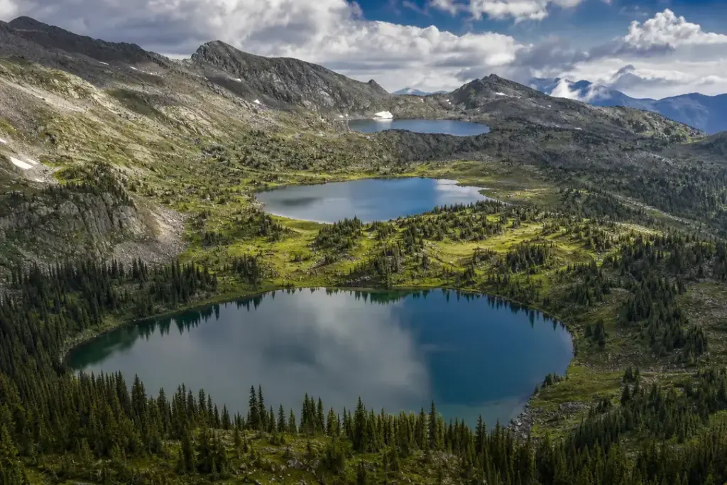
Karakol Lakes is a group of seven mountain lakes nestled in the heart of the Altai Mountains, in Russia’s Altai Republic. The lakes cascade down a mountainside across different elevations, each with its own character and landscape. The lowest lake sits at 1,820 metres, while the highest reaches approximately 2,097 metres, creating a stunning natural progression through multiple ecosystems.
Visiting these lakes offers an immersive experience in Siberian wilderness, where the water is cold and pristine, and the surrounding terrain shifts from dense coniferous forests to alpine meadows and rocky tundra.
Quick Facts
| Russian name | Озёра Каракол |
|---|---|
| Address | Altai Republic, Russia Google MapsApple MapsYandex Maps2GIS |
| District | Altai Mountains |
| Admission | free |
| Best time to visit | July and August are optimal—roads are most passable, trails clear of snow, wildflowers bloom, and weather is most stable. June can still have snow at higher elevations and boggy trails. September is possible but weather becomes unpredictable. October to May: roads impassable due to snow and mud; winter access extremely difficult. Weekdays are quieter than weekends. |
| Recommended duration | 4–6 hours (day visit) or 2–3 days (with hiking) |
What Is (and Isn't) Part of a Visit to Karakol Lakes, Altai Mountains?
| Part | Status | Notes |
|---|---|---|
| Access road and trailhead | Included in the standard ticket | Unpaved 4×4 track through taiga to the lower lakes; further hiking on foot required for upper lakes. |
| All seven lakes and connecting trails | Included in the standard ticket | Free roaming access to all lakes accessible via foot; some upper lakes require steep scrambling. |
| Camping or overnight stay | Not open to visitors | The site is a day visit destination; no official camping or accommodation. Backcountry camping may be possible but is not formally regulated. |
| Visitor facilities | Outside / not part of it | No toilets, shelters, shops or services on-site. Nearest supplies in Altai towns, 30+ km away. |
| Guided tours | Separate ticket or institution | Local operators in Altai towns can arrange guided visits with transport; independent travel requires advance planning. |
Why Visit Karakol Lakes, Altai Mountains?
Karakol Lakes reward visitors with dramatic mountain scenery and remarkable ecological diversity. The lakes themselves are fed by snowmelt and are exceptionally clear—the water contains few aquatic plants and no fish populations. As you ascend through the lake system, you encounter a full spectrum of landscapes: cedar and spruce forests at lower elevations giving way to fragrant alpine meadows dotted with wildflowers in summer, and finally tundra and bare rock at the highest lakes.
The site is accessible by vehicle (4×4 required) or on foot, making it suitable for various activity levels, though the remote mountain road demands preparation and respect for conditions.
How Karakol Lakes, Altai Mountains Is Laid Out
The seven lakes are spread vertically along a mountain valley, with the lower lakes near the road end and higher lakes accessible by hiking. The trail passes through distinct ecological zones: the approach traverses taiga (boreal forest) on an unpaved track, eventually leading to the foot of the lake system. From there, a hiking trail connects the lakes in sequence, gaining elevation as it progresses.
The landscape transforms progressively: the lower lakes are surrounded by thick cedar and spruce forest where mushrooms and berries grow in the damp undergrowth; the middle lakes sit in open alpine meadows with views to distant ridges; the upper lakes lie in rocky tundra with sparse vegetation. Streams connect some of the lakes, creating a natural corridor for exploration.
Highlights of Karakol Lakes, Altai Mountains
Lower Lakes in Cedar Forest
The first lakes encountered are cradled in dense Siberian cedar and spruce forest, creating a cool, sheltered environment. The forest canopy filters the light, and the ground is soft with moss and needles. These lower lakes have the warmest water (though still cold by lowland standards) and are the most accessible by vehicle, making them the first sight most visitors encounter on the journey up the valley.
Tip: The forest floor is often muddy due to streams and seepage—wear waterproof boots even for short walks around the lower lakes.
Alpine Meadow Lakes
At mid-elevation, the forest breaks open into expansive alpine meadows. The lakes here are surrounded by grasses, wildflowers (in summer), and low shrubs with views extending far across the mountains. This is the transition zone where weather changes rapidly and the air thins noticeably. The meadows provide the most dramatic photography, especially in early morning or late evening light.
Tip: Visit in July or August when wildflowers bloom; earlier in the year, trails may be boggy and snow can linger at passes.
Upper Tundra Lakes
The highest lakes sit in harsh alpine tundra—sparse, low vegetation clinging to rocky ground. The lakes at this elevation reflect a bare sky and appear almost alien compared to their forested cousins below. On clear days, the panoramic views extend to distant ridges; on cloudy days, the landscape becomes moody and monochromatic. These lakes are reached only on foot and reward the climb with solitude.
Tip: The upper lakes are often covered with ice well into June, so check conditions before attempting to visit them in early summer.
Stream Crossings and Natural Bridges
Throughout the lake system, glacial and snowmelt streams feed the lakes and cut the landscape. Several crossings require using logs laid across water or stepping carefully on rocks. These crossings add a sense of wilderness adventure and require attention—streams can be slippery and the water extremely cold. In heavy rain or during rapid snowmelt, water levels rise and crossings become more challenging.
Tip: Carry a walking pole to test water depth before crossing, and wear non-slip soles; many trails are slippery from horse traffic and water spray.
Ecological Transition Zones
What makes Karakol Lakes unique is the compact progression through multiple ecosystems in a single day trip. The 270-metre elevation range is small, yet the landscape transforms completely. This makes the site valuable for understanding how mountain ecosystems function and how plants and animals adapt to altitude and climate. The water itself changes—clearer and colder at higher elevations.
Tip: Binoculars reveal small alpine birds and marmots; in forest sections, listen for Siberian thrushes and other taiga species.
Seasonal Wildflower Display
In mid-summer (July–August), the alpine meadows are alive with wildflowers: columbines, edelweiss, alpine lupines, and others. The display peaks when snowmelt is complete and daytime temperatures warm the meadows. By late August, plants set seed and the meadows become more muted in colour. This seasonal transformation makes timing important for photography and nature observation.
Tip: Peak wildflower bloom is late July to early August; plan a visit for this window if flowers are a priority.
Vehicle Access Difficulty
The track to reach the lower lakes is rough, unpaved, and often extremely muddy. It passes through streams, over large rocks, and across deeply rutted sections. This is not a paved road and requires a sturdy 4×4 vehicle or specialised transport (traditional GAZ-66 military trucks are commonly used). The 30-kilometre approach can take 3–4 hours depending on road condition.
Tip: Do not attempt this road in a standard car; hire a local guide with appropriate vehicle to ensure safe passage and knowledge of current conditions.
Atmosphere
Karakol Lakes feels remote and untamed, even though road access exists. The air is clean and often cool, with the scent of coniferous forest at lower elevations and the sharp, thin atmosphere of altitude at the highest lakes. The sound landscape shifts: in the forest, birds and wind in the trees dominate; higher up, wind and the rush of streams become the main sounds. Solitude is typical—few visitors venture beyond the lowest lakes, so the upper reaches often feel completely wild.
The experience is distinctly Siberian: raw, pristine, and weather-dependent. Clouds build rapidly in afternoon, temperatures can drop suddenly, and sudden rain or hail is possible even in summer. This unpredictability gives the landscape a dramatic, slightly austere quality. Sunrise and early morning offer the clearest, most spectacular conditions.
Tickets and Booking for Karakol Lakes, Altai Mountains
Karakol Lakes is free to enter and requires no advance booking. Access is most practical through a local tour operator in nearby Altai towns, which typically provide 4×4 vehicle transport, driver, and basic guidance for a day trip. Independent visitors need a suitable vehicle (4×4 required), detailed route knowledge, and good physical condition for hiking.
There are no ticket offices, gates or official visitor infrastructure. Simply arrange access via a local tour company or hire a vehicle with an experienced driver. Travel times vary dramatically depending on road conditions—allow 6–8 hours total for a complete day visit including driving and hiking.
Plan and Book
Suggested itineraries Karakol Lakes, Altai Mountains
Day trip: 4–5 hours
Drive to the lower lakes (1–2 hours each way), spend 2–3 hours exploring the lower and mid-elevation lakes on foot, and return to base. This is the most common and accessible option, viewing the forest lakes and the transition to meadow ecosystems without high altitude challenge.
Day trip: 8–10 hours (full circuit)
Start early morning, drive to the trailhead, hike to the highest accessible lakes, experience all ecological zones, and return. This requires good fitness and careful time management to finish before dark. Bring water, snacks, and weather-resistant clothing.
Multi-day expedition: 2–3 days
Use backcountry camping to stay overnight at mid-elevation, allowing unhurried exploration of the upper lakes and time to acclimatise. This requires full camping equipment, navigation skills, and self-sufficiency but offers deeper wilderness experience.
How to Get to Karakol Lakes, Altai Mountains
By vehicle (recommended): Book a 4×4 tour through a local operator in Gorno-Altaysk, Ust-Kan, or other Altai towns. The journey involves a 30-kilometre unpaved mountain track through taiga forest—not suitable for standard cars. Drivers familiar with local conditions navigate mud, streams, rocks, and steep gradients.
Independent travel: Hire a 4×4 vehicle with driver in the nearest town. Route: head south from Ust-Kan towards the Karakol valley. No public transport serves the lakes directly. The drive from major towns (Gorno-Altaysk) is 4–6 hours to reach the trailhead.
On foot: Multi-day hiking from surrounding valleys is possible but requires detailed topographic maps, GPS, and mountain navigation experience.
Accessibility
The lower lakes are accessible by short walks from the parking area, but the road access is extremely difficult—not suitable for people with mobility challenges or motion sensitivity. Upper lakes require steep hiking on rough terrain with uneven footing, stream crossings, and altitude gain. No facilities for wheelchairs, accessible toilets, or assistance animals.
Food Nearby
No food or water services on-site. Bring all drinking water and snacks. Small shops and basic cafés exist in Ust-Kan (30 km away). Most visitors pack a picnic and eat lunch by the lakes.
What to Bring
Waterproof hiking boots with good grip (trails are muddy and rocky), rain jacket and waterproof pack cover (afternoon storms are common), extra socks, water bottles or hydration system (3+ litres), high-energy snacks, sunscreen and hat, warm mid-layer (temperature drops sharply with altitude), insect repellent (biting insects in summer, especially near streams), first-aid kit, and a headlamp if hiking late. The road is rough—pack motion sickness remedy if prone.
Best Views and Photo Spots of Karakol Lakes, Altai Mountains
Lower Lake forest framing
The first lower lake surrounded by dense cedar and spruce creates a dark frame reflecting on mirror-still water at dawn. Mountains are visible in the background above the treeline. The composition is intimate—the human scale of the forest contrasted with distant peaks.
Best time: Sunrise or early morning before clouds build; still water is essential—visit after stable weather.
Mid-elevation meadow lake overlook
Standing above one of the middle lakes with open meadow in foreground, the lake in middle distance, and bare mountains or tundra ridges beyond. The progression from green to grey to blue is dramatic. Wildflowers in foreground add colour (July–August).
Best time: Mid-morning when light is bright but shadows still have definition; clear days only for mountain contrast.
Stream crossing cascade
The branching streams where water cascades over rocks between lakes. Mist and spray create atmosphere, and if framed carefully, convey the scale and energy of snowmelt and altitude.
Best time: Late morning when light is high; after rain or rapid snowmelt when water flow is at its peak.
Upper tundra lake panorama
A high lake with barren tundra foreground, the lake body reflecting sky and distant ridges. Minimal vegetation emphasizes the alpine setting and altitude. Weather and light are highly variable—moody skies create drama.
Best time: When clouds break to reveal peaks, or in rare clear conditions for the fullest panorama. Often mid-afternoon before evening clouds.
Photography Rules
Photography is unrestricted. Drones are not prohibited by signage but their use in remote mountain areas should be respectful and practical—understand local wildlife laws. Tripods can be used on stable ground. The best light is early morning (clear, low angle) and golden hour before sunset. Cloud cover is common by afternoon. Reflections on still water are dramatic in early morning.
Family Suitability
The lower lakes (via short walks) are suitable for families with mobile children and teenagers. The 4×4 road is extremely rough—families with young children, pregnant women, or anyone with motion sensitivity may find the drive unpleasant. The upper lakes require strong hiking ability and altitude experience; families with young children should stay at lower elevations. Stroller access: not feasible on mountain trails, but short walks to the lowest lakes are possible on foot with a child in a hiking carrier.
Russia Vibes Tips
- Bring waterproof boots that cover the ankle—stream crossings are frequent, and mud is deep. The horses and herds that use the trail turn it into a slippery channel of hoof prints and water.
- Start your drive very early (dawn or earlier) to give yourself maximum daylight at the lakes and time to return to base safely. The 4×4 road can consume far more time than expected, and hiking in the dark on rough terrain is dangerous.
- Weather changes within minutes at altitude. Afternoon thunderstorms are common in summer—plan to descend from the highest lakes by early afternoon to avoid being caught in a storm at elevation.
- Do not underestimate the elevation. The highest lakes are at 2,097 metres—visitors from sea level may feel altitude effects. Ascend gradually, stay hydrated, and do not push if experiencing headache or dizziness.
- Mobile phone signal is absent or extremely patchy. Carry a paper map and compass or GPS device, and inform someone of your itinerary. The wilderness is genuinely remote, and rescue response times are long.
- The road is typically passable only June through September. Spring (April–May) and autumn (October) may be impassable; winter is impossible. Always confirm current road conditions with your local operator before traveling.
Explore Nearby Karakol Lakes, Altai Mountains
Related guides
 Altai Mountains: Best Places, Scenic Routes and Travel Tips
Main image: AI-generated illustration. It may not show the place exactly as it looks.
 Chuysky Trakt: Siberia’s Most Scenic Mountain Highway
Main image: AI-generated illustration. It may not show the place exactly as it looks.
Browse more: More in Altai Mountains · All Altai Mountains · All Parks · All Sightseeing · All Sightseeing in Altai Mountains
FAQ: Karakol Lakes, Altai Mountains
Can I visit Karakol Lakes without a guide or tour operator?
Yes, but with significant preparation. You need a suitable 4×4 vehicle, detailed maps or GPS, knowledge of current road conditions, and mountain hiking experience. Most independent travelers hire a local driver in the nearest town rather than attempting the drive alone. First-time visitors strongly benefit from a guide who knows the route and can warn of hazards.
Is the road really that difficult?
Yes—it is unpaved, muddy, crosses streams, and is deeply rutted. Standard cars will get stuck. Even 4×4 vehicles can take 3–4 hours to cover 30 km. The drive is legitimately rough and may cause motion sickness. This is not a scenic mountain road; it is a backcountry track.
How many lakes can I actually visit in a day?
Most people see the lowest 2–3 lakes clearly. Fit hikers can reach 5–6. The highest lakes require significant scrambling and altitude gain. A full circuit of all seven on foot is technically possible but rare—it requires full-day hiking plus 6–8 hours of driving.
What is the altitude, and can I get altitude sickness?
The lowest lake is at 1,820 metres, the highest around 2,097 metres. For most people this is mild altitude, but visitors from sea level may feel headache, slight breathlessness, or fatigue, especially if ascending too quickly. Drink water, rest, and acclimatise for an hour or two if you feel effects.
Is the water drinkable?
The lakes are clear and clean, but untreated water always carries the risk of parasites like giardia, especially downstream from herds. Carry your own drinking water or bring a water purification system (filter or tablets). Do not rely on drinking from the lakes.
Are there toilets, shelters, or supplies?
None on-site. There are no facilities whatsoever. Bring all food, water, and supplies from town. If you need a toilet, you must use the forest or tundra responsibly and away from water sources.
When is the best time to visit?
July and August are best: roads are most passable, snow is melted, trails are clear, and wildflowers bloom. June can still have snow at higher elevations. September is possible but weather becomes unpredictable. October to May, the road is typically impassable or dangerous.
How much does a tour cost?
Prices vary but typical day tours range from moderate to upscale depending on group size and vehicle type. Hiring a private 4×4 with driver is more expensive than joining a group tour. Costs are not fixed—agree in advance with your operator.
Russia Vibes is a one-person project. A coffee keeps it going
How we research and update our guides
About this guide: AI assistance and accuracy
This guide is created with the help of AI and is based on official sources where available. Mistakes can still happen. Opening hours, prices, rules and other details are given to the best of our knowledge as of the date shown and can change without notice. It offers general recommendations only, not professional, legal or travel advice. Please confirm important details with the official source before you travel; you are responsible for your own plans and decisions.
Packing for this trip
* Affiliate link: as an Amazon Associate we earn from qualifying purchases at no extra cost to you.

Take this guide with you
Get a free PDF of this guide to print or read offline: key facts, tips and a map link on a few clean pages.
Report an issue on this page
Paying for your trip: please read
International sanctions affect payments between Russia and many other countries. In practice, cards issued in the EU, the UK, the US and several other countries often do not work in Russia, Russian cards usually do not work abroad, and some booking platforms, airlines and payment providers limit or suspend their services for Russia. The situation changes frequently.
We do not give legal or financial advice, and this site does not encourage anyone to break or circumvent sanctions. Whatever you plan, you are responsible for following the laws and regulations that apply to you, including those of your country of residence and citizenship.
Many travelers still organise their stay lawfully. It is worth asking your bank or payment provider what is currently permitted, contacting hotels, tour operators and carriers directly about the payment methods they accept, and checking which services are open to customers from your country. Clarify payment, cancellation and refund terms before you commit to a booking, and keep your plans flexible.
Partner links on this site may not be available in every country, and prices, availability and rules in our guides can differ from what you see when you book.