
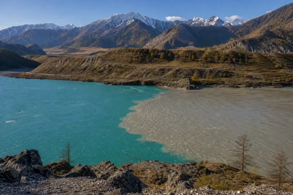
The confluence of the Chuya and Katun Rivers is located in the immediate vicinity of the Chuya Highway on the 713 kilometer of the road. This viewpoint along the famous Chuysky Trakt reveals one of the Altai’s most striking natural contrasts. The confluence of two rivers – the Chuya and the Katun – has long been considered sacred. The scene is distinctive because the two rivers visually merge, with one appearing distinctly more turbid than the other before fully blending together.
The stop is quick and easy to access while driving through the region. Most travelers visiting the Altai Mountains and following the Chuysky Trakt highway pass through this area, and the viewpoint observation deck is well-established. It works as an ideal pause during a longer journey through the Altai valleys.
Quick Facts
| Russian name | Слияние рек Чуя и Катунь |
|---|---|
| Address | Chuysky Trakt (R256 highway), km 713, Altai Republic Google MapsApple MapsYandex Maps2GIS |
| District | Altai Republic |
| Admission | Free |
| Best time to visit | Summer (June–August) offers the best light and clearest water colors, with the Katun at its brightest turquoise from glacial melt. Autumn (September–October) provides good weather and fewer crowds. Winter (December–February) is passable on the highway, but fewer visitors come, and light conditions are harsher. Spring (April–May) is unpredictable, as the road can be affected by snowmelt and condition changes. Midday light is harsh; late afternoon (after 3 pm) offers softer light for photography. |
What Is (and Isn't) Part of a Visit to Chuya and Katun Confluence, Altai Mountains?
| Part | Status | Notes |
|---|---|---|
| Confluence viewpoint with observation deck | Included in the standard ticket | Free, open 24 hours, accessible from the Chuysky Trakt parking area with short walks to the viewpoints. |
| Chui-Oozy National Natural Park | Separate ticket or institution | Established in 2012; visitor information and any activities may have separate management or fees—check locally. |
| Rafting and water activities on the Katun or Chuya | Separate ticket or institution | These require separate arrangements with outfitters and are not part of a basic visit to the viewpoint. |
Why Visit Chuya and Katun Confluence, Altai Mountains?
The view offers very beautiful vistas of the bend of the wide Katun River. Photographers appreciate the contrasting colors: the gray water of the Chuya river enters the turquoise water of the Katun river. The Chuya is 232 km long and a right tributary of the Katun, while the Chuya drains a basin of 9,550 square kilometers. The natural scenery reflects the surrounding Altai landscape, and from ancient times the confluence is seen as a sacred and respected place, with the name “Chui-Oozy” translating from Altai as “mouth of the Chuya River.”
Highlights of Chuya and Katun Confluence, Altai Mountains
Observation Deck and Viewpoint
The viewpoint is located at kilometer 713 of the Chuya Highway. After leaving the car in the parking lot, a 200-meter walk to the high bank of the Katun reveals very beautiful views of the bend of the wide Katun River. The vantage point is elevated, giving a clear perspective of how the two rivers converge below.
Tip: Arrive in late afternoon when the sun illuminates the turquoise water and the surrounding peaks cast longer shadows, creating better photo contrast.
Color Contrast of the Waters
You can see how the gray water of the Chuya river enters the turquoise water of the Katun river. The Chuya River's muddy waters flow into the Katun and do not mix at first, but then the Katun absorbs the waters of the Chuya. This visual phenomenon lasts for several kilometers downstream before complete blending.
Tip: The color contrast is most visible in summer and early autumn when glacial melt feeds the Katun with fresh water that maintains its bright turquoise hue.
Walking Along the Steep Bank
To see the mouth of the Chuya River, you need to walk about 200 meters more along the steep bank, where the Chuya River looks small with its muddy waters. This additional walk takes you to a lower vantage point with a more intimate view of the actual confluence point.
Tip: Wear sturdy shoes for the uneven terrain along the bank. The path is informal and can be steep in places, particularly if there has been recent rain.
Katun River Valley Terraces
Rocky shore and famous terraces above the Katun River mark its confluence with the Chuya River. The geological formations visible here show how the Katun has carved through the Altai landscape over millennia, creating dramatic stepped banks.
Tip: Look upward and to the sides to see the layered rock formations that reveal the river's geological history and the mountain erosion patterns.
Gateway to Two River Valleys
The Chuya Highway runs for hundreds of kilometers in the valleys of these great rivers of Altay. The segment running along the Valley of the Katun River is quite short, only 30 kilometers, after which the highway stretches along the Chuya Valley for 210 kilometers. This confluence marks the natural division between two distinct valley landscapes.
Tip: Continue south on the Chuysky Trakt to drive alongside the Chuya Valley for dramatic canyon and steppe scenery. The road becomes increasingly scenic beyond the confluence.
Atmosphere
The confluence is visited mostly as a roadside stop during a longer drive. The observation deck is a simple, elevated platform with clear sightlines to both rivers and the surrounding mountains. It typically draws small groups of travelers who pause for 20–30 minutes to walk around, take photographs, and observe the water colors.
The landscape is alpine and open, with rocky banks and sparse vegetation. Wind can be noticeable at the viewpoint. In summer, the area is busier with traffic; in winter, the highway is still passable but fewer tourists visit. The light quality changes throughout the day, transforming the appearance of the water colors and the surrounding ridges.
History of Chuya and Katun Confluence, Altai Mountains
From ancient times, the confluence has been seen as a sacred place in Altai tradition, with the site known as “Chui-Oozy,” which translates from Altai as “mouth of the Chuya River.” The site’s spiritual significance predates modern tourism and remains embedded in local culture.
The Chuysky Trakt, the road that now brings visitors to this viewpoint, was constructed in the early 1930s by gulag inmates. The modern road was officially opened in 1935, though the route had been mentioned in Chinese chronicles for over a thousand years and in Russian sources since 1788. The confluence viewpoint became an established stop along the route as the highway developed into a major tourist corridor.
In 2012, this place was declared a national natural park, which was named Chui-Oozy. This designation formalized its importance as a protected natural and cultural landmark within the Altai Mountains region.
Legends and Myths about Chuya and Katun Confluence, Altai Mountains
Sacred Confluence and Place of Power
Legend – historically unreliable. The confluence of the two great Altay rivers Chuya and Katun is traditionally called the Place of Power of the Altay Mountains. Local belief holds that the meeting of these two rivers generates spiritual energy tied to the region's natural forces. The distinction between the two waters—one turbid, one clear—has been interpreted by some as representing different aspects of mountain life. This tradition reflects deep roots in Altai indigenous spirituality and continues to influence how locals and visitors perceive the site.
Tickets and Booking for Chuya and Katun Confluence, Altai Mountains
There is no ticket required to visit the confluence viewpoint. The site is free and accessible 24 hours a day. A simple parking area is located adjacent to the Chuysky Trakt highway at kilometer 713, clearly marked for the confluence stop. The walk from the car park to the main observation deck takes about 200 meters and is straightforward.
No advance booking or online registration is needed. Simply stop at the marked area while driving the Chuysky Trakt. The site has no specific hours and no formal visitor center, though the observation deck is regularly maintained.
Plan and Book
Suggested itineraries Chuya and Katun Confluence, Altai Mountains
30 minutes
Park at the marked area, walk to the main observation deck (200m), and observe the river confluence and surrounding peaks. This is sufficient to see the color contrast and take photographs. It works as a quick break during a longer road journey.
45 minutes
In addition to the main observation deck, walk an extra 200 meters along the steep bank to see the actual mouth of the Chuya River where it enters the Katun. Stop to observe the geological terraces and the detailed interaction of the two water flows before returning to the car.
2–3 hours (as part of a road day)
Visit the confluence stop, then continue south on the Chuysky Trakt for another 30–50 kilometers to explore the Chuya Valley or Kuray Steppe. Stop at other scenic viewpoints or small settlements to experience the broader landscape. The confluence acts as a natural midpoint in a longer road day between Biysk and Kosh-Agach.
How to Get to Chuya and Katun Confluence, Altai Mountains
The Chuya and Katun Confluence is accessed via the Chuysky Trakt (federal highway R256), which runs from Biysk in the north to the Mongolia border in the south. The confluence viewpoint is located at kilometer 713 of the Chuya Highway.
By car: The site is a marked roadside stop on the highway. Coming from Biysk (approximately 130 km north), drive south on the R256 until the signed parking area. From Gorno-Altaysk (about 170 km north), also follow the R256 south. The drive from either city takes 3–4 hours.
By organized tour: Most Altai tour operators and travel agencies in Gorno-Altaysk and Biysk include this stop in multi-day mountain tours. The place is probably included in most excursions around Altai.
There is no direct public transport (bus or train) to the viewpoint. A car, taxi, or organized tour is essential.
Accessibility
The observation deck has a paved or well-compacted surface accessible to visitors with mobility concerns, though there is a gentle incline. The walk to the additional viewpoint along the steep bank is uneven and not suitable for wheelchairs or those with limited mobility. No wheelchair-accessible restrooms are available at the site. The parking area is standard and accessible by car.
Food Nearby
No restaurants, cafes, or food vendors are present at the confluence viewpoint itself. The nearest village with food options is Ongudai, approximately 40 km south on the Chuysky Trakt, which has small cafes and shops. Travelers are advised to carry snacks and water. A cooler with food is practical if spending time here during the day.
What to Bring
Wear sturdy, closed-toe shoes suitable for uneven terrain and steep banks. Bring water and sun protection (hat, sunscreen) as the viewpoint is exposed and in direct sun. Wind can be strong, so a light jacket is useful even in summer. Camera or smartphone for photographs. Binoculars can enhance observation of distant peaks and the water mixing zone.
Best Views and Photo Spots of Chuya and Katun Confluence, Altai Mountains
Main observation deck overview
Wide vantage of the entire confluence showing both rivers, the contrasting turquoise and gray waters, and the surrounding mountain ridges. This is the classic panoramic shot.
Best time: Late afternoon (after 3 pm) when the sun illuminates the water colors and casts shadows on the far bank, enhancing depth and contrast.
Close-up of the water mixing zone
Detail of where the gray Chuya waters meet the turquoise Katun, showing the gradual blending. Best captured from the lower section of the viewpoint or along the bank walks.
Best time: Midday when the sun is high and the turquoise color is most vibrant, or late afternoon for softer tones and texture.
Rocky terraces and bank formations
The layered rock face and steep banks show the geological history and add foreground interest to the landscape composition.
Best time: Early morning or late afternoon when low-angle light accentuates the rock textures and casts shadows.
Distant mountain peaks above the confluence
The surrounding Altai ridges framing the river valley, visible from the observation deck. Clean mountain silhouettes dominate the background.
Best time: Clear mornings and late afternoons; avoid midday haze. Early autumn (September) often offers the clearest visibility.
Photography Rules
Photography is freely allowed at the viewpoint. No drones are permitted without special authorization from local authorities. Tripods may be used but should not obstruct other visitors on the observation deck. Flash photography is unnecessary and not recommended outdoors. The contrasting water colors are most vivid in daylight; consider visiting in late afternoon for warmer, more dramatic light.
Family Suitability
The site is suitable for families with children aged 5 and up. The main observation deck is easily accessible and safe. The additional walk along the steep bank requires adult supervision and is not suitable for very young children or those who fear heights. No stroller access to the lower viewpoint. The site involves walking on uneven ground, so comfortable shoes are essential for children. The visit can take 20–45 minutes depending on exploration level, keeping young children interested.
Russia Vibes Tips
- Visit in early morning or late afternoon for better light quality and photography opportunities. Midday sunlight can be harsh and wash out the water colors.
- Park safely and completely off the highway. The parking area is small and traffic moves quickly. Do not attempt to cross the highway except at designated areas.
- The walk to the lower viewpoint along the steep bank is informal and exposed. Stay on visible paths and do not venture onto unstable rocky areas. In wet conditions, the terrain can be slippery.
- Carry water and snacks as there are no facilities at the viewpoint. A full meal is not feasible during a short stop, but refreshments make the visit more comfortable.
- The site is included in most multi-day Altai tours, but a self-driven route offers more flexible timing to linger and explore without following a tour schedule.
- Do not throw objects into the river or disturb the banks. The confluence holds spiritual significance for local people, and the natural landscape is protected within the Chui-Oozy National Natural Park.
Explore Nearby Chuya and Katun Confluence, Altai Mountains
Related guides
 Altai Mountains: Best Places, Scenic Routes and Travel Tips
Main image: AI-generated illustration. It may not show the place exactly as it looks.
 Uchar Waterfall: Hiking to Russia’s Most Remote Cascade
Main image: AI-generated illustration. It may not show the place exactly as it looks.
 Ukok Plateau: Remote Expedition Across Ancient Steppe
Main image: AI-generated illustration. It may not show the place exactly as it looks.
 Akkem Lake: Alpine Trek to Mount Belukha’s Base
Main image: AI-generated illustration. It may not show the place exactly as it looks.
 Shavlo Lakes: Turquoise Waters and Glacier Peaks
Main image: AI-generated illustration. It may not show the place exactly as it looks.
Browse more: More in Altai Republic · All Altai Mountains · All Sightseeing · All Sightseeing in Altai Mountains · All Viewpoints
FAQ: Chuya and Katun Confluence, Altai Mountains
Can you see where the two rivers merge?
The Chuya's muddy waters flow into the Katun and do not mix at first, but then the Katun absorbs the waters of the Chuya. Yes, you can clearly see the point of entry and the gradual blending over several hundred meters downstream. The color contrast is most visible from late spring through early autumn.
Is there a parking area and facilities?
Yes, there is a marked parking area at kilometer 713 of the Chuysky Trakt. However, there are no restrooms, food vendors, or visitor center at the site. The nearest services are in the village of Ongudai, about 40 km south.
How long should we plan to spend here?
30–45 minutes is typical for viewing the main observation deck and taking photographs. If you also walk along the steep bank to the actual mouth of the Chuya, allow up to 1 hour. Most travelers treat it as a brief roadside stop during a longer road journey.
Is the viewpoint accessible year-round?
Yes, the viewing area is open 24 hours. The Chuysky Trakt highway is maintained and passable in winter, though conditions can be challenging in heavy snow. Summer offers the best accessibility and clearest views.
Can you swim or raft here?
The viewpoint is for observation only. Swimming and rafting are separate activities organized by outfitters downstream or at designated sections of the rivers. The river is fast-flowing and cold; do not wade in.
Is the site part of a national park that requires a ticket?
In 2012, this place was declared a national natural park, named Chui-Oozy. The observation viewpoint itself is free. Any formal park activities or amenities may have separate requirements; check locally for current information.
What is the spiritual significance of this place?
The confluence has long been considered sacred; from ancient times it is seen as a sacred and respected place in Altai, with the name 'Chui-Oozy' translating from Altai as 'mouth of the Chuya River.' It is traditionally called the Place of Power of the Altai by local people.
Can this stop be combined with other Altai attractions?
Yes, the confluence is on the main Chuysky Trakt route. It connects naturally with stops in the Chuya Valley, Kuray Steppe, mountain passes (Seminsky, Chike-Taman), and villages like Ongudai and Kosh-Agach. Many multi-day tours include it as one of several stops.
Russia Vibes is a one-person project. A coffee keeps it going
How we research and update our guides
About this guide: AI assistance and accuracy
This guide is created with the help of AI and is based on official sources where available. Mistakes can still happen. Opening hours, prices, rules and other details are given to the best of our knowledge as of the date shown and can change without notice. It offers general recommendations only, not professional, legal or travel advice. Please confirm important details with the official source before you travel; you are responsible for your own plans and decisions.
Packing for this trip
* Affiliate link: as an Amazon Associate we earn from qualifying purchases at no extra cost to you.

Take this guide with you
Get a free PDF of this guide to print or read offline: key facts, tips and a map link on a few clean pages.
Report an issue on this page
Paying for your trip: please read
International sanctions affect payments between Russia and many other countries. In practice, cards issued in the EU, the UK, the US and several other countries often do not work in Russia, Russian cards usually do not work abroad, and some booking platforms, airlines and payment providers limit or suspend their services for Russia. The situation changes frequently.
We do not give legal or financial advice, and this site does not encourage anyone to break or circumvent sanctions. Whatever you plan, you are responsible for following the laws and regulations that apply to you, including those of your country of residence and citizenship.
Many travelers still organise their stay lawfully. It is worth asking your bank or payment provider what is currently permitted, contacting hotels, tour operators and carriers directly about the payment methods they accept, and checking which services are open to customers from your country. Clarify payment, cancellation and refund terms before you commit to a booking, and keep your plans flexible.
Partner links on this site may not be available in every country, and prices, availability and rules in our guides can differ from what you see when you book.