
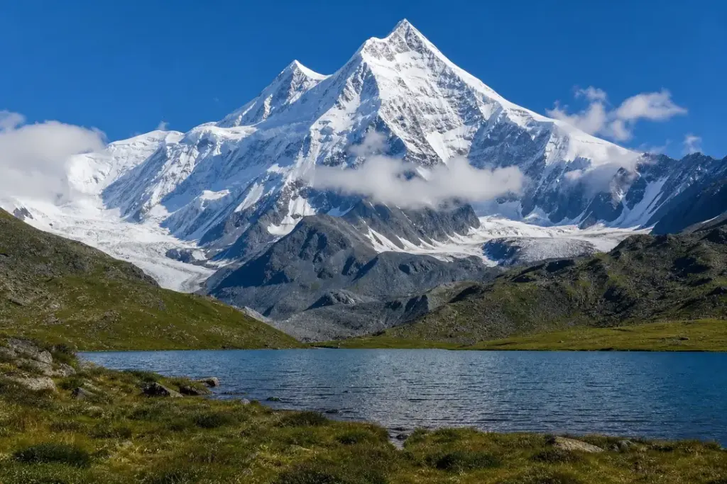
Mount Belukha is the highest mountain of the Altai Mountains and the tallest peak in the entire South Siberian range. The twin-peaked massif reaches 4,509 metres and straddles the Russia-Kazakhstan border in the far south of the Altai Republic, within the Golden Mountains of Altai UNESCO World Heritage site.
The mountain rises almost equidistant from three oceans—the Arctic, Pacific and Indian—placing it near the geographic centre of the Eurasian landmass. Year-round snow and extensive glaciers cover the upper slopes. Serious mountaineers visit for technical climbing; trekkers approach via valleys and passes through pristine mountain forest for views of the peak and surrounding ranges.
Quick Facts
| Russian name | Белуха |
|---|---|
| Built / opened | 1914 |
| Address | Google MapsApple MapsYandex Maps2GIS |
| District | Altai Republic |
| Best time to visit | July and August are the only reliable climbing months. July offers longer daylight but more frequent thunderstorms. August is typically more stable with clearer skies, though still unpredictable. June sometimes allows trekking to base camp if snow passes early. September can have both clear skies and early snow, making conditions risky. Outside this window, snow, cold and avalanche danger make the mountain inaccessible to most parties. Late July to mid-August sees the most expeditions and the highest success rates on the summit. |
| Recommended duration | 10–14 days |
What Is (and Isn't) Part of a Visit to Mount Belukha, Altai Mountains?
| Part | Status | Notes |
|---|---|---|
| East Belukha summit (4,509 m) | Included in the standard ticket | The main climbing objective and highest point; requires mountaineering experience, ice axe, crampons and technical training. |
| West Belukha peak (4,440 m) | Included in the standard ticket | The lower sister peak separated from East Belukha by a saddle; requires similar technical climbing experience. |
| Belukha plateau and base camps | Included in the standard ticket | Alpine terrain at 3,500–4,000 m open to acclimatised climbers; forms part of any expedition approach. |
| Akkem Lake and valley trekking | Included in the standard ticket | Non-technical hiking and camping in valleys and to base camp at approximately 2,150 m; open to trekkers without climbing experience. |
| Belukha Nature Park buffer zones | Included in the standard ticket | Surrounding foothills and trekking routes within the nature park; require entry permits and may require guides. |
| Katun Nature Reserve (upper slopes and glacier fields) | Separate ticket or institution | The strictest reserve zone protects the upper mountain; separate access rules and permissions apply beyond trekking zones. |
| Kazakhstan-side approach (Berel Valley) | Separate ticket or institution | An alternative climbing route via Kazakhstan's East Kazakhstan Region; requires separate entry permissions, visa and guides; rarely used by international mountaineers today. |
Why Visit Mount Belukha, Altai Mountains?
Belukha represents the highest ambition for mountaineers working in Siberia and Central Asia. The East Belukha summit (4,506 m) has been repeatedly climbed since 1914 and offers a technical challenge on rock and ice within reach of experienced climbers with proper training. Non-climbers trek to base camps at Akkem Lake and other vantage points to witness the towering white peak and glaciated terrain.
The mountain holds spiritual significance for local Altai people and Buddhists. The approach trek crosses high passes and pristine taiga forest, revealing the raw beauty of the Altai wilderness. The massif is geographically remarkable and holds genuine mountaineering prestige across Russia.
Highlights of Mount Belukha, Altai Mountains
East Belukha Summit
The higher of two main peaks at 4,509 metres, this is the standard mountaineering objective. The approach ascends via the Akkem glacier and Delone Col, then crosses a high plateau before a steep summit push with fixed ropes. First climbed by the Tronov brothers in 1914, it offers dramatic views across the Altai and into Kazakhstan.
Tip: Climbing typically takes 10–14 days from the village of Tyungur. Most ascents occur in July and August during the brief summer climbing season.
West Belukha Peak
The lower sister peak stands at 4,440–4,453 metres and is separated from East Belukha by a wide saddle. The West peak is less frequently climbed and presents different route options. Both summits are visible from base camp positions, making the twin-peaked massif iconic from every approach angle.
Tip: The saddle between peaks is a natural resting point if attempting to traverse both summits, though this is an advanced undertaking.
Akkem Lake and Base Camp
This glacial lake sits in a cirque beneath the Akkem Wall, a 1,000-metre rock face. Most expeditions establish base camp here (around 2,150 m) after trekking through mountain taiga. The lake is crystal clear and reflects the massif's glaciers. The Akkem Wall looms dramatically above and features technical rock and ice climbing routes.
Tip: The trek to Akkem Lake takes about 4–5 days of walking and does not require climbing skills, making it accessible for trekkers who want extended views of Belukha.
Glaciers and Glaciokarst Formations
Approximately 70 square kilometres of glaciers cover Belukha's slopes—the largest being the Berel Glacier. Permanent ice fields, crevasses, serac formations and meltwater channels define the upper mountain. These glaciers give rise to the Katun River, one of the Altai's major waterways.
Tip: Glacier crevasses require ropes and harnesses; independent glacier travel is dangerous. All mountaineers must receive technical training beforehand.
Delone Col
A high mountain pass at approximately 3,700 metres that sits between Belukha's two peaks. Most summit routes cross this col as the gateway to the plateau and final slopes. The pass offers a natural rest point and orientation for climbers.
Tip: Altitude acclimatisation is critical; the col sits above most acclimatisation camps. Many expeditions spend a night on the Belukha plateau (around 4,000 m) before the summit push.
Kucherla Lake and Kara-Turek Pass
The scenic approach route to Akkem Base Camp passes through Kucherla Lake in the lower valleys and crosses the Kara-Turek pass (3,060 m). This segment takes 2–3 days and passes through alpine meadows and mountain taiga forest, offering acclimatisation and mountain immersion before technical climbing begins.
Tip: The pass is snow-covered in early summer (June) and completely snow-free by late August. Conditions vary significantly year to year.
Yarlu Valley
An alternative approach valley to the north of the main climbing routes, Yarlu is sacred to local Altai beliefs and hosts a small shrine connected to Russian explorer and mystic Nicolas Roerich, who visited the Altai in the 1920s. The valley provides a quieter trekking alternative for those seeking a spiritual approach to the mountain.
Tip: The Yarlu approach is less crowded than the main Akkem route and works well for trekkers with time to explore secondary valleys.
Belukha Nature Park
A protected natural park encompassing the mountain massif and surrounding peaks. The park preserves alpine and subalpine ecosystems and forms a buffer around the stricter Katun Nature Reserve where Belukha's highest slopes sit. Twenty-two named peaks surround Belukha within the park boundary.
Tip: Independent entry permits and guides may be required; check current regulations with local tourism offices in the Altai Republic before travel.
Atmosphere
Belukha demands respect. The approach trekking routes wind through silent mountain forests where the only sounds are water and wind. High altitude becomes progressively thinner; breathing becomes laboured. At base camp, the massif dominates every view—a white fortress of ice and rock rising 2,000 metres above. The Akkem Wall looms dramatically, serac seracs catch sunlight, and the summit appears impossibly distant and high.
Climbers on the upper slopes work in extreme conditions: cold, altitude, exposed terrain and technical rock and ice. The summit day begins in pre-dawn darkness. By dawn, climbers are on the plateau or approaching the final slopes, racing against afternoon weather. Local Altai people view the mountain as sacred and spiritually significant. The landscape feels primordial and untouched.
History of Mount Belukha, Altai Mountains
Mount Belukha remained unclimbed by any documented expedition until 1914, when brothers Boris Tronov and Mikhail Tronov successfully summited East Belukha, establishing the standard mountaineering route. The first ascent was relatively late in the age of high-altitude mountaineering, reflecting the mountain’s remote location and the difficulty of approach.
The mountain has always held cultural and spiritual significance for Altai indigenous peoples, who called it Kadyn Bazhy (meaning sacred), and in Altay language, Üç-Sümer (‘the three peaks’). In the 1920s, Russian mystic and explorer Nicolas Roerich passed through the Altai and visited the region, strengthening the mountain’s association with spiritual seekers and adding to Western mystical literature about the area.
In 1998, Mount Belukha and the surrounding landscape were inscribed as part of the Golden Mountains of Altai UNESCO World Heritage Site, recognising the region’s biodiversity, geological significance and pristine wilderness value. This designation brought increased climbing and trekking activity in subsequent decades, though the mountain remained relatively unknown to mainstream mountaineering until the early 2000s.
Today, dozens of mountaineering expeditions approach annually during the July-August climbing season. Routes remain technically consistent with the 1914 ascent, with fixed ropes now installed on sections of the summit approach. The mountain’s remote location and difficult access keep visitor numbers lower than comparable peaks in more developed regions.
Legends and Myths about Mount Belukha, Altai Mountains
Belukha as Shambala
Legend – historically unreliable. Buddhist and Altai spiritual traditions connected Mount Belukha to Shambala, the legendary hidden kingdom from Tibetan and Buddhist mythology. The mountain's remote location, year-round snow cover, spiritual associations among local peoples and isolation from modern civilisation fuelled beliefs that it was a gateway or physical representation of this sacred realm. Western occultists and mystics in the 20th century adopted these interpretations, visiting the Altai as pilgrims.
The White Princess
Legend – historically unreliable. Local Altai legends describe Belukha as an eternal white princess, eternally snowbound and the sacred mother of the Katun River. The river originates from glaciers on the mountain's slopes and flows northward. The metaphor appears in trekking and climbing literature as a poetic description of the mountain's sovereignty over water and landscape.
Roerich's Spiritual Pilgrimage
Disputed by historians. Russian artist, mystic and explorer Nicolas Roerich passed through the Altai Mountains in the 1920s during a trans-Asian journey. He visited the region near Mount Belukha and documented the landscape and local spiritual beliefs. His accounts merged Western esotericism with Altai shamanism, establishing the mountain as a magnet for spiritual seekers throughout the 20th century.
Tickets and Booking for Mount Belukha, Altai Mountains
Access and Permits: Mount Belukha sits within protected reserves. International visitors typically hire licensed expedition companies or mountain guides based in the Altai Republic (usually in or around the village of Tyungur or the city of Gorno-Altaysk) to handle permits, logistics and guide services. Independent access may be restricted or complicated by permit requirements.
Expedition Duration and Timing: Most mountaineering expeditions operate only in July and August during the brief summer climbing window. Trekking approaches to base camp can sometimes operate in June and September, but snow conditions vary. Expeditions typically last 10–14 days from arrival at Tyungur village.
Booking: International climbers should book 2–3 months in advance with established mountaineering tour operators. Popular dates (mid-July to mid-August) fill quickly. Operators provide all technical equipment, food, guides and camp logistics; climbers must arrive with climbing skills (ice climbing to approximately Grade II/Alpine PD+ standard) and physical fitness for sustained high-altitude mountaineering.
Check with the Altai Republic tourism authorities or licensed operators for current permit fees, entry requirements and regulations, as these are subject to change. Note that regulations for Russian citizens and concessions differ; consult your operator.
Suggested itineraries Mount Belukha, Altai Mountains
Day hike (6–8 hours)
Drive or hike from Tyungur village to Kucherla Lake area or lower Akkem Valley. Short walks through taiga forest and meadows offer views toward the mountain and allow acclimatisation without technical commitment. Return same day to village or base camp.
3–4 days
Trek from Tyungur through Kucherla Lake area and cross Kara-Turek pass. Reach Akkem Lake base camp by day 3 or 4. Spend final day exploring the lake and Akkem Wall, photographing the peak, then descent.
7–8 days
Full acclimatisation trekking approach via Kucherla Lake and Kara-Turek pass, reaching Akkem base camp. Rest, acclimatise and explore side valleys. Descent via same route. Suitable for trekkers seeking high-altitude wilderness experience without technical climbing.
10–14 days
Complete mountaineering expedition: trek approach via Kucherla Lake and Kara-Turek pass to Akkem base camp (4–5 days), acclimatisation climbs to plateau (2–3 days), summit attempt on East Belukha with final ascent via Akkem glacier, Delone Col and high plateau (1–2 days), descent to base camp (1 day), then exit trek (2–3 days).
How to Get to Mount Belukha, Altai Mountains
Village Approach: The gateway is Tyungur village in the Ust-Koksinsky District of Altai Republic. Tyungur is approximately 120 km south of Gorno-Altaysk (the capital of Altai Republic) and 350–400 km from Novosibirsk by road. Hire a guide, vehicle or tour operator in advance; independent driving is possible but remote access is difficult.
By Air and Ground: Fly to Novosibirsk International Airport (the nearest major hub) or the smaller airport at Gorno-Altaysk. Rent a vehicle or arrange a transfer to Tyungur, typically 5–7 hours drive south through the Altai region. Roads are unpaved in sections and seasonally variable (June to September are passable).
From Tyungur: Expeditions begin trekking from Tyungur village, which lies at approximately 900 metres elevation. The standard route proceeds south toward Kucherla Lake and then to the higher alpine zones. Allow 4–5 days of walking to reach Akkem base camp near the mountain.
No public transport reaches Tyungur regularly. Tour operators or hired local guides typically arrange all logistics including vehicle transport from Gorno-Altaysk or Novosibirsk, porters, pack animals and camp supplies.
Accessibility
This is a remote, high-altitude mountain environment requiring serious mountaineering experience, fitness and acclimatisation. There are no facilities, marked trails or rescue infrastructure beyond what your expedition provides. Climbers must be self-sufficient in difficult terrain. Standard mountaineering safety requirements apply: rope work, glacier travel, crevasse rescue, altitude physiology. The mountain is not accessible to visitors with mobility limitations, children, or those without significant mountaineering or high-altitude trekking experience.
Food Nearby
Tyungur village has a few small shops selling basic supplies (bread, canned goods, tea, fuel). Gorno-Altaysk, 120 km north, has supermarkets and restaurants. Once on the mountain, expeditions carry all food; resupply is impossible. Tour operators typically provide meals as part of the package. Plan provisions carefully during the trek in.
What to Bring
Mountaineering-grade equipment for alpine and glacier climbing: ice axe, crampons, harness, rope, helmet, rock and ice protection. Insulated mountaineering boots rated to -30°C, down suit, windproof shell, gloves and balaclava. Sleeping bag rated to -20°C, thick sleeping pad, tent designed for snow anchors. High-altitude cooking stove, fuel and dehydrated food. First-aid kit, sunscreen and lip balm (altitude intensifies UV). Trekking poles, gaiters and base layers. Passport, travel insurance and cash in Russian rubles (cards may not work). Book all arrangements (permits, guides, transport) weeks in advance as access is via licensed operators only.
Best Views and Photo Spots of Mount Belukha, Altai Mountains
Akkem Lake shoreline
Crystal-clear glacial water reflects the twin peaks and the thousand-metre Akkem Wall. Foreground meadow and wildflowers (July-August) provide depth. Midday light is harsh; early morning and evening offer softer angles and warmer tones.
Best time: Early morning or late afternoon in July and August for golden light; clear-sky days in mid-August typically offer stable weather.
Kara-Turek Pass (3,060 m)
Elevated vantage point showing Belukha's twin peaks in full profile above lower valleys. Panoramic views across multiple ridges and valleys of the Altai; foreground includes subalpine meadows or sparse vegetation.
Best time: Mid-morning or late afternoon to avoid backlighting; August offers stable clear skies.
Belukha Plateau (approximately 4,000 m)
Ultra-high vantage point on the mountain itself. Dramatic close views of the twin summits, the Berelsky Saddle, surrounding glaciers and the distant Kazakh steppe to the south. Extremely rarefied and harsh light.
Best time: Pre-dawn and dawn during summit day before clouds form; late July and August have most stable conditions.
Lower Kucherla Lake approach
Alpine meadow and lake surrounded by forested ridges; Belukha visible from distance across valleys. Softer, more intimate landscape than the stark high-altitude views; wildflowers dominant in July.
Best time: Mid-summer (July) for wildflower colour; mornings offer mist and softer light.
Photography Rules
Tripods and drone photography may be restricted within nature reserve zones; check with your guide. Wide-angle lenses capture the massif's scale from base camp. Polarising filters cut haze at altitude. Bring lens cloth and protect equipment from moisture and cold (batteries drain faster). Ice and snow create intense glare; quality sunglasses essential.
Family Suitability
Mount Belukha is not suitable for families with young children or non-mountaineers. The trekking approaches to base camp (4–5 days) involve sustained uphill walking at increasing altitude and rough terrain; children must be experienced hikers and acclimatised. The summit climb requires mountaineering-grade technical skills, cold-weather endurance and altitude experience—suitable only for skilled adult climbers. Base camp and lower-valley treks may accommodate family groups with serious backpacking experience, proper equipment and realistic fitness expectations, but expect tough conditions and limited facilities.
Russia Vibes Tips
- Book your expedition 2–3 months in advance. July and August fill quickly and permits require lead time. Last-minute walk-ups are not feasible.
- Acclimatisation is critical. Do not skip acclimatisation days on the plateau or lower base camps, even if your expedition timeline feels tight. Altitude sickness can be fatal; slow ascent saves lives.
- Weather changes violently and suddenly. A clear morning can become a whiteout within hours. Have flexible summit dates and accept that summit attempts may be cancelled or delayed; retreating from high altitude in bad weather is not failure—it is survival.
- Tyungur village is tiny and rustic. Bring cash (rubles), fuel your vehicle before arriving, and arrange all supplies with your guide company in advance. There are no emergency services; evacuation is expensive and slow.
- The Russia-Kazakhstan border runs along Belukha's ridge. International mountaineers must approach only from the Russian (north and west) side; the Kazakhstan approach requires separate permits, visas and arrangements. Crossing the border at altitude is illegal for tourists.
- Train seriously before arrival. Ice climbing, rock climbing and high-altitude experience are non-negotiable. Many expeditions turn back due to climber fitness or skill shortfalls; arriving unprepared wastes money and endangers the team.
Explore Nearby Mount Belukha, Altai Mountains
Related guides
 Altai Mountains: Best Places, Scenic Routes and Travel Tips
Main image: AI-generated illustration. It may not show the place exactly as it looks.
 Gorno-Altaysk: Gateway to the Altai Mountains
Main image: AI-generated illustration. It may not show the place exactly as it looks.
 Chuya and Katun Confluence: Free Viewpoint and Sacred Altai LandmarkOpen 24 hours
Main image: AI-generated illustration. It may not show the place exactly as it looks.
 Uchar Waterfall: Hiking to Russia’s Most Remote Cascade
Main image: AI-generated illustration. It may not show the place exactly as it looks.
 Ukok Plateau: Remote Expedition Across Ancient Steppe
Main image: AI-generated illustration. It may not show the place exactly as it looks.
Browse more: More in Altai Republic · All Altai Mountains · All Landmarks · All Sightseeing · All Sightseeing in Altai Mountains
FAQ: Mount Belukha, Altai Mountains
Do I need mountaineering experience to climb Belukha?
Yes. The standard East Belukha route requires ice axe and crampons proficiency, rope work, crevasse rescue skills and sustained high-altitude mountaineering experience (Alpine Grade II/PD+). Without this, you cannot safely summit. However, trekking to Akkem base camp requires only good fitness and hiking experience.
Can I reach Mount Belukha independently without a guide company?
Access is controlled through permit systems and protected nature reserves. International visitors almost always book with licensed expedition operators. Independent access may be legally restricted or logistically difficult. Use a tour operator or guide service based in Altai Republic.
How many days does a Belukha expedition take?
Expect 10–14 days total: 4–5 days trekking approach from Tyungur to base camp, 3–4 days acclimatisation and preparation, 1–2 days for summit attempt, and 2–3 days return trek. Weather delays can extend this significantly.
What is the climbing difficulty?
The East Belukha summit route is graded Alpine PD+ to AD- (modéré difficulty) in mountaineering terms. Routes vary: the standard Akkem glacier approach is PD+; alternative rock and ice routes are harder (4B to 5A UIAA). Choose based on your skill level and guide assessment.
What are the main hazards?
Altitude (4,509 m), extreme cold, crevasses, ice and rock falls, rapid weather changes, isolation from rescue, and avalanches. Mountaineers die on Belukha periodically; it is a serious alpine peak. Respect the risks and train thoroughly.
When can you climb Belukha?
Only July and August offer reliable conditions. July has longer days but more storms. August typically has more stable weather. June and September are marginal; the rest of the year is inaccessible due to snow, cold and darkness.
Is the Belukha plateau accessible without summiting the peak?
Yes. Skilled mountaineers with glacier and high-altitude experience can reach the Belukha plateau (approximately 4,000 m) as a climbing objective without pushing to the final summit cone. This offers high-altitude alpine scenery and views without the technical upper-slope climbing.
What is the spiritual significance of Mount Belukha?
Belukha is sacred to Altai indigenous peoples and respected in Buddhist and mystical traditions. Legends connect it to Shambala and the 'white princess.' Visitors should show respect for these cultural beliefs and not treat the mountain purely as a sportive challenge.
Russia Vibes is a one-person project. A coffee keeps it going
How we research and update our guides
About this guide: AI assistance and accuracy
This guide is created with the help of AI and is based on official sources where available. Mistakes can still happen. Opening hours, prices, rules and other details are given to the best of our knowledge as of the date shown and can change without notice. It offers general recommendations only, not professional, legal or travel advice. Please confirm important details with the official source before you travel; you are responsible for your own plans and decisions.
Packing for this trip
* Affiliate link: as an Amazon Associate we earn from qualifying purchases at no extra cost to you.

Take this guide with you
Get a free PDF of this guide to print or read offline: key facts, tips and a map link on a few clean pages.
Report an issue on this page
Paying for your trip: please read
International sanctions affect payments between Russia and many other countries. In practice, cards issued in the EU, the UK, the US and several other countries often do not work in Russia, Russian cards usually do not work abroad, and some booking platforms, airlines and payment providers limit or suspend their services for Russia. The situation changes frequently.
We do not give legal or financial advice, and this site does not encourage anyone to break or circumvent sanctions. Whatever you plan, you are responsible for following the laws and regulations that apply to you, including those of your country of residence and citizenship.
Many travelers still organise their stay lawfully. It is worth asking your bank or payment provider what is currently permitted, contacting hotels, tour operators and carriers directly about the payment methods they accept, and checking which services are open to customers from your country. Clarify payment, cancellation and refund terms before you commit to a booking, and keep your plans flexible.
Partner links on this site may not be available in every country, and prices, availability and rules in our guides can differ from what you see when you book.