
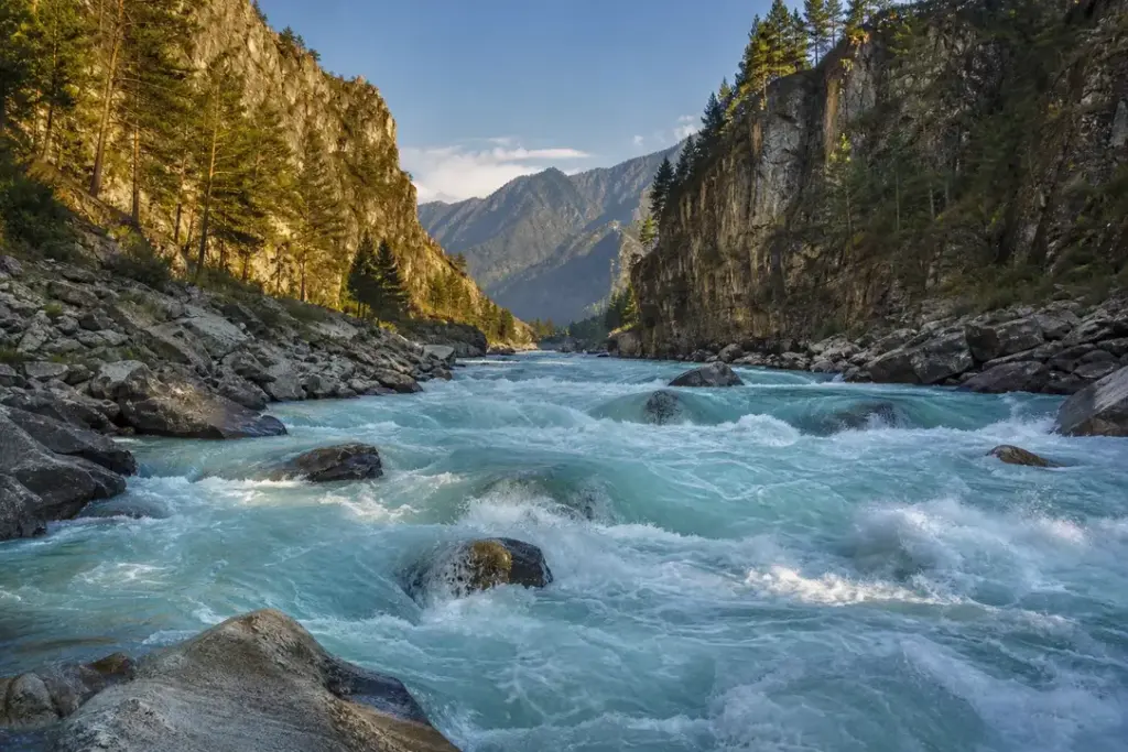
The Katun is a river in the Altai Republic and the Altai Krai of Russia, and one of the most prized waterways for adventure in Siberia. The Katun is 688 kilometres long, and its drainage basin covers 60,900 square kilometres. From its glacier-fed source high in the mountains, the river carves through dramatic canyons and flows across high plateaus before joining the slower Biya near Biysk.
The Katun’s character changes dramatically along its course. In the mountains, it runs as a wild torrent of white water with serious rapids; further downstream it widens into pools of turquoise and emerald green. The Katun is a turbulent mountain river with lots of rapids. At this point the Katun roars in a narrow canyon formed by high indented rocks. For visitors, the river offers world-class rafting, trekking opportunities, and some of the most spectacular Altai scenery.
Quick Facts
| Russian name | Река Катунь |
|---|---|
| Address | Google MapsApple MapsYandex Maps2GIS |
| Admission | free |
| Best time to visit | Late June through August is the optimal season. Water levels and temperatures are manageable, weather is most stable, and the longest daylight hours suit multi-day trips. July is the driest and warmest month. June water is colder (recent snowmelt) and faster; September begins to cool and water levels drop. Avoid May (extreme flooding and cold) and October through April (snow, ice, and river freezing). For vehicle-based sightseeing, summer (June–August) offers the best weather, but spring (May–early June) is dramatic if you tolerate unpredictable conditions and higher water. |
| Recommended duration | Full day to 3 days |
What Is (and Isn't) Part of a Visit to Katun River, Altai Mountains?
| Part | Status | Notes |
|---|---|---|
| Katun River (the full river from source to mouth) | Included in the standard ticket | Free to view and access along public roads and established paths; no admission fee. |
| Katun Nature Reserve | Separate ticket or institution | Strict nature reserve with limited public access; separate permit required (contact reserve directly). Most visitors experience nearby trekking instead. |
| White-water rafting | Separate ticket or institution | Guided rafting tours require booking and payment; arrange through Gorno-Altaysk tour operators. Equipment provided by tour operators. |
| Chuysky Trakt highway viewing areas | Included in the standard ticket | The main scenic highway runs alongside the middle river; pullouts and viewpoints are free and open to public use. |
| Chemalskaya Hydroelectric Power Station | Separate ticket or institution | Not open for tourist visits; viewable from distance along lower river routes and highway. |
| Tavda Caves near lower river | Separate ticket or institution | Cave tours require separate booking and guide; offered as optional add-on on some rafting trips. |
Why Visit Katun River, Altai Mountains?
The Katun River reveals the Altai Mountains at their most dramatic. The Katun is a turbulent mountain river with lots of rapids, making it ideal for white-water rafting experiences ranging from family-friendly to technical. Rafting along the Middle Katun River is rightfully considered the most popular water route in Altai. The section of the Middle Katun meets basic criteria of organized water tourism: convenient access to the starting point, the possibility of passing rapids along the shore, beautiful nature, a fairly comfortable climate and the absence of mosquitoes with midges.
The river is also a cultural landmark: the Katun’ was the first river explored by foreign whitewater rafting enthusiasts. This is one of the most commonly run rivers in the Altai so there are many stories about this run. Hiking trails follow the river’s canyon walls, offering close views of the water and surrounding rock formations. Local villages along the route provide authentic glimpses of mountain life.
Highlights of Katun River, Altai Mountains
Source at Belukha Mountain
The Katun originates in the Katun glaciers on the southwestern slope of Belukha Mountain. The headwaters of the Katun River originate on Mount Belukha, the highest mountain in Siberia at 4,506 metres. The glacial waters emerge milky white at high altitude (2,300 metres) before beginning their 688-kilometre journey northward. Accessing the source requires serious mountaineering and is typically part of multi-week expeditions. Most visitors experience the Katun river lower down in the valley.
Tip: The source is accessible only to mountaineers with experience and guides; most trekking and rafting experiences begin at lower elevations.
Middle Katun Rafting Section
Rafting along the Middle Katun River is rightfully considered the most popular water route in Altai. The section of the Middle Katun meets the basic criteria of organized water tourism: convenient access to the starting point, the possibility of passing rapids along the shore, beautiful nature, a fairly comfortable climate and the absence of mosquitoes with midges. Rafting along the Middle Katun river includes a number of interesting rapids of 3-4 k.s. Among the key thresholds are 'Ilgumen', 'Kadrinsky breakthrough', and 'Sabbath' of 5 k.s., one of the most dangerous and unpredictable rapids of the middle Katun.
Tip: The Middle Katun season runs June through September; book guides through Gorno-Altaysk tour operators; water conditions change with snowmelt (higher and faster in June–July).
Lower Katun Canyon
Below the major rapids, the Katun enters its lower reaches where the character transforms. In its lower reaches, close to the confluence with the Biya River, the Katun becomes a calm steppe river. During the tour visitors pass lots of interesting places: Chemalsky tract, Sartakpai gate, Chemalskaya Hydroelectric Power Plant, Patmos Island, Kamyshlinsky waterfall, Tavda caves, Turquoise Katun, Lake Aya and others. This section is accessible year-round and suits families.
Tip: The lower section is best visited via the scenic Chuysky Trakt highway, which runs parallel to the river.
Turquoise Pools
Between the rapids and the lower reaches, the Katun collects in striking turquoise pools where clear days allow you to see the river bottom despite its depth. These pools form where the river slows temporarily before plunging into the next rapid. The colour comes from glacial silt suspended in the water. These spots make excellent stops on driving tours and photo opportunities.
Tip: Turquoise colour is most vivid on sunny days; visit viewpoints early morning to avoid crowds on popular routes.
Katun Nature Reserve
Katun Nature Reserve is a Russian zapovednik (strict nature reserve) located in the highlands of the central Altai Mountains of south Siberia. Katun is an internationally important center of biodiversity, forming part of the 'Golden Mountains of Altai' UNESCO World Heritage Site. Access is limited to protect the reserve, but surrounding areas offer trekking that showcases the same landscape.
Tip: The reserve does not allow casual day visits; explore the trekking trails in surrounding areas instead, or join organized nature tours.
Chuya River Confluence
The Chuya is a right tributary of the Katun. The Chuya is 320 kilometres long, and its drainage basin covers 11,200 square kilometres. The two rivers meet in a dramatic landscape where the narrower Chuya (often glacier-fed and bright turquoise) joins the larger Katun. The confluence marks a major landmark on the Chuysky Trakt highway.
Tip: The confluence point is visible from the highway; roadside pullouts offer photo opportunities.
Seasonal Freeze-Thaw Cycle
The river freezes up in the late November – early December and breaks up in the early or mid-April. Winter transforms the Katun into a landscape of ice and snow. In spring, the combination of snowmelt and glacier discharge creates powerful floods, making the rapids at their most serious and dangerous. Summer water levels drop and become more manageable for tourists.
Tip: Plan rafting trips for June through September for the safest conditions; January through March the river freezes solid in mountain areas.
Path to the Ob River
The Katun forms the Ob as it joins the Biya some 19 kilometres southwest of Biysk. This confluence marks the birth of one of Russia's largest rivers and the end of the Katun's independent journey. The Ob continues northward for thousands of kilometres to the Arctic Ocean. At the confluence the landscape has transformed from mountains to foothills and steppe.
Tip: The town of Biysk marks the point where the Katun ceases to exist as a named river and becomes part of the Ob system.
Atmosphere
The Katun River carries the raw energy of the high mountains into more settled country. In the upper sections, the sound is thunderous—rocks crashing in rapids, water roaring through narrow gorges. The air is cold and clean, sometimes shrouded in mist from spray. Along the middle reaches, you’ll find rafting groups at campsites in evening light, hiking boots drying by fires. The water’s colour shifts from white foam in rapids to brilliant turquoise in calm pools. Downstream, the pace slows; the roar becomes a murmur, and the landscape opens. Villages and farms appear. Locals fish the river in summer. In spring, the Katun is a raw force of snowmelt and power. By late summer, it calms and cools. The river is always in motion, always cutting deeper into the mountains.
History of Katun River, Altai Mountains
The Katun River has shaped human settlement in the Altai for centuries. Archaeological evidence shows that indigenous Altai peoples used the river as a main route and food source, particularly for fish. Rock carvings (petroglyphs) along the river’s banks record human presence dating back thousands of years, though exact dating remains uncertain.
In the 18th century, the river became a route for Russian explorers and fur traders expanding into Siberia. The harsh topography limited settlement to fishing camps and temporary trading posts. The name ‘Katun’ derives from the Altai language, meaning ‘woman’ or ‘queen’—possibly reflecting the river’s power and importance to local peoples.
By the 19th century, the Katun had become known to a wider world through geographical surveys and travel accounts. Russian settlement increased following the completion of the Altai Post Road (later called the Chuysky Trakt) in the early 20th century. This highway, built roughly parallel to the river’s middle reach, opened the region to tourism and trade.
The Katun Nature Reserve was established in 1991 to protect the river’s ecosystem and the surrounding highlands as part of the larger ‘Golden Mountains of Altai’ UNESCO World Heritage Site. Modern tourism on the Katun—especially white-water rafting—began in the late Soviet era and accelerated in the 1990s after the fall of communism. Foreign rafting teams began exploring the river in the late 1980s, and today it is one of Russia’s most popular rafting destinations for both domestic and international adventure tourism.
Legends and Myths about Katun River, Altai Mountains
The Woman and Her Suitor
Legend – historically unreliable. Local Altai legend describes the Katun as a powerful woman fleeing from the Biya River (male), which pursues her northward. The swift rapids and channels represent her desperate flight. The legend explains not just the river's wild character but also the eventual union where the two rivers merge to form the Ob—a symbolic marriage of opposites after a great struggle. In this telling, the Katun's energy and colour come from her independent spirit.
The Ghost of Belukha
Legend – historically unreliable. In folklore, a spirit is said to dwell in the Belukha glaciers where the Katun originates. The spirit awakens each spring, breaking free from ice and sending torrential water down the mountain. The white roar of the spring flood is described as the spirit's cry of freedom. Local shamanic traditions hold that the Katun carries this spiritual force throughout its journey and that touching its waters—especially during dangerous rapids—is to touch the sacred mountain's power.
Tickets and Booking for Katun River, Altai Mountains
The Katun River itself is free to access along public roads and established trails. For organized activities, book through tour operators based in Gorno-Altaysk or Barnaul. Rafting companies offer multi-day and single-day trips; availability is highest June through September. Online booking platforms include local adventure tour websites; many operators have English-language versions. Minimum age for rafting typically starts at age 8 for family sections (III class rapids) and increases for advanced sections (IV–V class). Tours include all equipment and guides; bring your own waterproof bag for personal items. For independent visits, the Chuysky Trakt highway and river-adjacent paths are freely accessible year-round by car or foot.
Plan and Book
Suggested itineraries Katun River, Altai Mountains
Half day (vehicle-based)
Drive the Chuysky Trakt highway from Gorno-Altaysk toward Biysk, stopping at river viewpoints. Stop at the Chuya River confluence (visible from the road) and Teldekpen rapids lookout. Aim for the turquoise pool sections in mid-afternoon light. Return to Gorno-Altaysk by evening. Best for those short on time or preferring non-strenuous sightseeing.
1 day (rafting beginner)
Join a guided lower-Katun rafting trip (typically 5–7 hours) starting from the Edigan confluence or near Chemal. Pass family-friendly rapids (I–II class) with scenic stops at Turquoise Katun pools and nearby caves. End near Rybalka or Chemal village where you can explore shops and local cafes before returning to Gorno-Altaysk.
3–4 days (rafting intermediate)
Mid-Katun rafting expedition from the Bolshoy Yaloman confluence to Kuyus. Includes challenging rapids (III–IV class), camping on river beaches, and daytime exploration of side valleys. Typical July–August itinerary with morning safety briefing, full-day rafting, evening meals cooked on fires, and night camping. Includes professional guide and all equipment.
7–8 days (full mountain expedition)
Combine upper-Katun valley trekking with multi-day rafting. Start with bus transfer from Barnaul via Chuysky Trakt; day hikes near Tungur, glacial lakes trekking (Kucherla Lake, etc.), then 4–5 days of advanced rafting (III–IV+ class) down the middle river. End with lower-river easy sections. Includes accommodation, all meals, guides, and equipment.
How to Get to Katun River, Altai Mountains
By road: The Katun River is paralleled for much of its middle reach by the Chuysky Trakt highway (M-52), one of Russia’s most scenic roads. From Gorno-Altaysk (the main hub for Katun access), drive south on the Chuysky Trakt toward Biysk. The river is visible from the road at multiple points. Pullouts with river views are marked and free.
By air: Gorno-Altaysk airport (Altai International Airport, direct flights from Moscow) is the nearest major airport. International visitors can also arrive via Novosibirsk (about 650 km north) with onward bus or flight to Gorno-Altaysk.
By bus: Regular bus service connects Gorno-Altaysk and Barnaul to river-access towns (Chemal, Tugur, Kuyus). Long-distance buses run the Chuysky Trakt; you can board to reach river viewpoints or tour meeting points.
For rafting: Most tours include transportation from Gorno-Altaysk or a central meeting point. Your tour operator will provide pickup details.
Accessibility
The Katun River itself is not fully accessible for visitors with mobility limitations. The landscape is rugged mountain terrain with steep slopes and no paved paths. Roadside viewpoints along the Chuysky Trakt are accessible from vehicles. Some pullouts have parking suitable for people who can walk short distances (10–50 metres). Rafting trips are not suitable for people with mobility restrictions due to boat boarding and uneven terrain. Trekking opportunities require fitness and balance. No wheelchair rental services operate in the area. For visitors with mobility concerns, the best option is viewing from the Chuysky Trakt highway or hiring a private car with a driver.
Food Nearby
Riverside camping on multi-day rafting trips includes meals prepared on fires by guides. For day visitors using the Chuysky Trakt, small cafes and shops operate in villages like Chemal, Manzherok, and Tugur. Basic provisions (bread, canned food, water, tea) can be purchased at village stores. Gorno-Altaysk (the hub, 2–3 hours' drive north) has full grocery stores and restaurants. Self-catering for day trips is recommended; bring water and snacks, as facilities are sparse along the river.
What to Bring
Bring waterproof bag or dry bag for electronics and valuables if rafting. Wear water shoes or sandals with good grip (rocks are slippery). Sunscreen and hat are essential; the sun reflects intensely off water and stone. Lightweight, quick-dry clothing works better than cotton. Sweater or fleece is needed for mornings and evenings at higher elevations. Rain jacket is advisable even in summer; mountain weather changes rapidly. Insect repellent is useful though less critical near the fast-moving river. Multi-day rafting trips typically include a packable dry bag; inquire with your tour operator. Regular security rules: leave valuables in locked accommodation, not unattended on riverbanks.
Best Views and Photo Spots of Katun River, Altai Mountains
Chuya River Confluence (Chuysky Trakt km marker ~660)
Wide view of where the narrow turquoise Chuya (left bank) joins the larger, greyer Katun (right bank) in a V-junction. Roadside pullout with guard rail; camera-ready in all light conditions. The rock walls of the canyon frame the rivers.
Best time: Morning (09:00–11:00) when sun illuminates the canyon walls without shadows; the turquoise contrast is clearest in midday bright sun.
Teldekpen Rapids Viewpoint
Elevated view of the Katun roaring through a narrow rocky gorge with visible white rapids and spray. The canyon walls rise steeply on both sides. A roadside sign marks this spot on the Chuysky Trakt.
Best time: Afternoon light (14:00–16:00) when shadows catch the canyon geometry; best in June–July when water volume is high.
Turquoise Pool at Manzherok
Clear stretch of river in bright emerald-turquoise colour, framed by riverside grass and distant mountains. The water is calm enough to reflect sky. This is one of the iconic Altai river colours; it's near the village of Manzherok.
Best time: Midday (10:00–14:00) on sunny days; the turquoise is most vivid in clear daylight. Avoid overcast days.
Lower Katun near Chemal
The river opens into a wider valley with fewer rapids; the water colour shifts to grey-green. Riverside villages, small bridges, and cultivated fields appear, showing human settlement. The mountain backdrop is gentler.
Best time: Late afternoon (17:00–19:00) when side-light catches the vegetation and water surface.
Belukha Mountain across valley (from lower Katun valley roads)
Distant view of Mount Belukha (4,506 m), the highest peak in Siberia, from the lower Katun valley. The white-capped peak dominates the southern horizon. Access requires hiking into valleys or viewing from certain pullouts.
Best time: Early morning (07:00–09:00) before clouds rise; the peak is often shrouded by afternoon cloud even on clear days.
Photography Rules
Photography is permitted freely along the river and Chuysky Trakt viewpoints. Drones are not permitted in the Katun Nature Reserve (if you venture that far). Tripods work on stable ground; many photo spots have natural rocks to anchor equipment. Flash is not necessary outdoors. The turquoise pools are most photogenic in bright midday sun; shadows in canyons require good camera settings or patience for light angles. Reflections off water are excellent early morning or late afternoon.
Family Suitability
The Katun River suits families with varying activity levels. Younger children (ages 5–8) are best suited to vehicle-based exploration (driving the Chuysky Trakt and stopping at viewpoints) rather than rafting or hiking. Family-friendly rafting (I–II class rapids, calm sections) is available for ages 8 and up; tour operators provide life jackets and supervise closely. Stroller access is limited; the terrain is rugged and uneven. Older children (ages 10+) can enjoy moderate day hikes along riverside paths or easy rafting. Multi-day rafting expeditions require fitness and are better for ages 12+. Toilet facilities and shelter are limited outside villages. Self-catering families should bring snacks and water. Most tour companies accept children if they meet age and swimming-ability requirements; confirm directly with your operator.
Russia Vibes Tips
- Avoid May and September–October: May brings extreme spring flooding and cold water (dangerous for rafting); autumn brings sudden weather changes and early snow at higher elevations. Peak season is July–early August.
- Book multi-day rafting trips at least 2–3 weeks in advance, especially for July–August. Good tour operators fill quickly. Last-minute slots fill with less-experienced guides.
- Start from Gorno-Altaysk, not Barnaul: Gorno-Altaysk (2.5 hours closer to the river) has more tour operators, better infrastructure, and shorter drive times to the river itself.
- The water is glacier-fed and remains cold (around 10–15°C even in summer). Wear a wetsuit on multi-day trips even in July; regular clothes dry slowly and you'll lose body heat at night.
- Sunburn and dehydration happen fast at high altitude: use SPF 50+ sunscreen and drink more water than you think necessary. The dry mountain air is deceptive.
- Don't expect solitude in summer: the Middle Katun is the most popular rafting river in Altai. June and September are quieter than July–August, though conditions are less ideal.
Explore Nearby Katun River, Altai Mountains
Related guides
 Altai Mountains: Best Places, Scenic Routes and Travel Tips
Main image: AI-generated illustration. It may not show the place exactly as it looks.
Browse more: All Altai Mountains · All Landmarks · All Sightseeing · All Sightseeing in Altai Mountains
FAQ: Katun River, Altai Mountains
Is the Katun River safe for rafting?
Rafting along the Middle Katun River is the most popular water route in Altai. The section meets the basic criteria of organized water tourism with convenient access, the possibility of passing rapids along the shore, beautiful nature, and fairly comfortable climate. Guided tours with reputable operators are safe. Avoid solo independent rafting unless you are an experienced paddler. Always wear a life jacket and listen to your guide.
Can you visit the Katun Nature Reserve?
The reserve has restricted access to protect ecosystems. Day visits are not permitted for tourists. Trekking trails in surrounding areas (outside the reserve boundary) offer similar mountain scenery. To enter the reserve, contact the reserve administration directly or join research expeditions.
What is included in a rafting tour?
Most multi-day rafting tours include: transportation to the start point, rafts, paddles, life jackets, helmets, wetsuits, meals (usually cooked on riverside fires), camping equipment, and professional guides. What is NOT typically included: alcohol, extra snacks, toiletries, personal first aid, tips for guides. Confirm the exact inclusions when booking.
How far is the Katun from Gorno-Altaysk?
The river flows within 2–150 km of Gorno-Altaysk depending on the section. The scenic Chuysky Trakt highway runs parallel to the middle river; the drive from Gorno-Altaysk south toward the Chuya confluence is 2–3 hours. Rafting start points (like Bolshoy Yaloman) are 4–6 hours' drive south.
Is the Katun frozen in winter?
The river freezes up in late November–early December and breaks up in early or mid-April. Mountain sections freeze solid; lower sections freeze less completely but become treacherous. Winter activities are limited to frozen surface walks (with caution) or specialist ice travel. Most tourism is summer-only.
Can you fish in the Katun?
The Katun is known for fishing in lower sections (below the main rapids). You'll need a Russian fishing license (obtainable through tour operators or in Gorno-Altaysk). Upper sections are protected by the Katun Nature Reserve. Check current regulations locally.
What is the Chuysky Trakt and does it follow the Katun?
The Chuysky Trakt (M-52 highway) is the main scenic road connecting northern and southern Altai. It runs roughly parallel to the Katun River's middle reach for several hundred kilometres. The road offers easy access to river viewpoints, pullouts, and villages without rafting or hiking.
Is it possible to do the Katun as a day trip from Barnaul?
Yes, barely. Barnaul is about 600 km north. A day trip involves 10+ hours of driving. A better option is to fly or bus to Gorno-Altaysk (2.5 hours south of Barnaul), spend the night, and use Gorno-Altaysk as your base for a full day on the river.
Russia Vibes is a one-person project. A coffee keeps it going
How we research and update our guides
About this guide: AI assistance and accuracy
This guide is created with the help of AI and is based on official sources where available. Mistakes can still happen. Opening hours, prices, rules and other details are given to the best of our knowledge as of the date shown and can change without notice. It offers general recommendations only, not professional, legal or travel advice. Please confirm important details with the official source before you travel; you are responsible for your own plans and decisions.
Packing for this trip
* Affiliate link: as an Amazon Associate we earn from qualifying purchases at no extra cost to you.

Take this guide with you
Get a free PDF of this guide to print or read offline: key facts, tips and a map link on a few clean pages.
Report an issue on this page
Paying for your trip: please read
International sanctions affect payments between Russia and many other countries. In practice, cards issued in the EU, the UK, the US and several other countries often do not work in Russia, Russian cards usually do not work abroad, and some booking platforms, airlines and payment providers limit or suspend their services for Russia. The situation changes frequently.
We do not give legal or financial advice, and this site does not encourage anyone to break or circumvent sanctions. Whatever you plan, you are responsible for following the laws and regulations that apply to you, including those of your country of residence and citizenship.
Many travelers still organise their stay lawfully. It is worth asking your bank or payment provider what is currently permitted, contacting hotels, tour operators and carriers directly about the payment methods they accept, and checking which services are open to customers from your country. Clarify payment, cancellation and refund terms before you commit to a booking, and keep your plans flexible.
Partner links on this site may not be available in every country, and prices, availability and rules in our guides can differ from what you see when you book.