
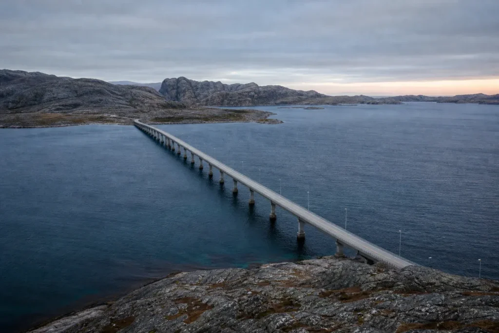
The Bridge Across Kola Bay is a four-lane highway connecting Murmansk‘s eastern shore to the western districts of Murmansk Oblast and beyond. Opened in 2005, it spans the Kola Bay’s narrowest point and has become the longest automobile bridge north of the Arctic Circle.
The structure crosses 2.5 kilometers end to end, with 1.6 kilometers passing directly over water. For most visitors, the bridge is experienced as a driving route—you cross it when heading west toward the Barents Sea coast, Norwegian border, or Finnish frontier. It also serves as an important viewpoint where you can see the bay’s expansive waters and the city skyline behind.
Quick Facts
| Russian name | Мост через Кольский залив |
|---|---|
| Built / opened | 2005 |
| Address | Pribrezhnaya Street, Murmansk OpenStreetMap · Google Maps |
| District | Murmansk |
| Opening hours | Open 24 hours |
| Admission | Free |
| Best time to visit | Midday in spring (May–June) offers the midnight sun effect, with continuous daylight that illuminates the bridge and bay beautifully around the clock. Summer (June–August) brings mild weather and maximum visibility. Autumn (September) is crisp and clear. Winter (November–January) offers polar night, a unique experience, though weather can be harsh; December sometimes brings clear skies perfect for stargazing. Avoid heavy traffic times if possible (morning and late afternoon local time). Weekdays are generally less congested than weekends. |
| Recommended duration | 15–20 minutes (as a driving route or short pedestrian visit) |
What Is (and Isn't) Part of a Visit to Bridge Across Kola Bay, Murmansk?
| Part | Status | Notes |
|---|---|---|
| The bridge roadway | Included in the standard ticket | The main four-lane highway crossing is open 24 hours to all traffic with valid vehicle documentation. |
| Pedestrian crossing | Included in the standard ticket | The bridge does not have a dedicated pedestrian path, but walking is technically possible on the shoulder; it is unsafe and not recommended. |
| Scenic overlooks or rest areas | Outside / not part of it | The bridge itself has no designated stopping areas or viewpoints; any attempt to stop on the roadway is dangerous and likely illegal. |
| Public facilities (restrooms, shops, cafés) | Outside / not part of it | No facilities exist on the bridge; the nearest services are in Murmansk (to the east) or western settlements. |
| Toll or entry fees | Included in the standard ticket | The bridge is free to cross; no tickets, permits, or tolls are required for standard vehicle traffic. |
Why Visit Bridge Across Kola Bay, Murmansk?
The bridge itself is infrastructure rather than a traditional sightseeing stop, but it serves several purposes for visitors. It offers one of Murmansk’s longest unobstructed views across the Kola Bay and the surrounding terrain. If you are renting a car or joining an excursion heading west, you cross it as a practical gateway.
The bridge also carries historical and engineering significance: it ended decades of detours and opened direct access between Murmansk and its western hinterland. Between 2005 and 2009, it held the record for the longest road bridge in the Arctic. On clear days, the Barents Sea horizon and the bay’s rocky shorelines create a dramatic backdrop.
Highlights of Bridge Across Kola Bay, Murmansk
The Main Span Across Open Water
The 1.6-kilometer central span crosses the bay's deepest section, giving the impression of traveling far out to sea. The bridge is most visually striking in this segment. On the northern side, you see the Barents Sea opening to the horizon; on the southern side, Murmansk's waterfront recedes. The bridge's modern arch design is most evident here.
Tip: Stop at the westernmost pull-offs or scenic overlooks (if available) to photograph the bay; the best light is in mid-afternoon when the water reflects the sky.
Pribrezhnaya Street Approach
The eastern entrance begins near Pribrezhnaya Street in central Murmansk, close to the city's main commercial and port areas. This approach gives you a sense of how the bridge integrates into the city's transportation network and connects urban Murmansk to the open landscape beyond.
Tip: The street-level approach from the east offers glimpses of the bay before you reach the bridge proper; if you are a pedestrian, the approach walk provides context for the structure's role in the city.
Monument or Marker at Midpoint
A stella (commemorative stone marker) stands somewhere along the bridge, marking the crossing. Local references mention this marker as a notable feature, though its exact location and current state vary.
Tip: Ask your driver or guide to point it out; it serves as a traditional stopping point for travelers crossing the bridge.
Western Terminus and Landscape Shift
As you exit the bridge to the west, the landscape changes noticeably. The rocky, slightly more open Barents Sea coastline replaces the urban setting. This western shore is less developed than Murmansk's east side and offers a different perspective on the region's geography.
Tip: If you are driving, the shift in scenery marks your transition to the western Murmansk Oblast; this is a good spot to orient yourself if heading to coastal destinations.
Views in Polar Night and Midnight Sun
The bridge's appearance changes dramatically with Murmansk's extreme seasons. In polar night (November to January), it appears as a thin line against darkness and stars. In midnight sun (May to July), it remains fully lit, and the water reflects the low-angle light continuously.
Tip: Visit in May or June for the midnight sun effect; the bridge and bay are illuminated around the clock. In December, the polar night and rare clear skies create an otherworldly atmosphere.
Route to Norwegian and Finnish Crossings
The bridge carries the Federal Highway R21 and European Highway E105, the main routes toward Norway and Finland. It serves not as a destination but as the gateway crossing for international travelers.
Tip: If you are driving to Scandinavia, remember that the bridge itself is toll-free, but you must have valid travel documents and may need permits (check current rules with your embassy or ride-share app).
Atmosphere
The bridge is a utilitarian structure with modern engineering design. The journey across is typically quick (2–3 minutes by car), so the atmosphere depends on your pace and whether you stop. During the crossing, you are suspended between the city behind and open Barents landscape ahead, with water on both sides.
The soundscape is dominated by vehicle traffic and wind, especially in cold months. In summer, the low-angle midnight sun bathes the bay in golden light. In winter, the structure stands against an often-grey sky, and ice may form along the shoreline. Few pedestrians cross on foot; most travelers are drivers.
The bridge can feel isolated even though it is very much a working highway; the sense of crossing a threshold between civilizations (city and wilderness, Russia and Scandinavia) lingers.
History of Bridge Across Kola Bay, Murmansk
The bridge was constructed over a 13-year period from 1992 to 2005, a unusually long timeline that reflected the scale and difficulty of the project. The first stage was completed in 2004 and officially opened on 11 October 2005 by Russia’s Prime Minister Mikhail Fradkov. The bridge’s opening marked the end of a long detour: previously, travelers heading west from Murmansk were forced onto circuitous routes around the bay.
Construction began in 1992, shortly after the Soviet Union‘s collapse, reflecting post-Soviet Russia’s ambitions to modernize its Arctic infrastructure. The arch bridge design was chosen to accommodate the bay’s depth and winter ice conditions. The 2.5-kilometer structure—with 1.6 kilometers spanning water—required specialized engineering to handle the Arctic environment, including extreme cold, ice formation, and high winds.
At its opening, the bridge became the world’s longest automobile bridge north of the Arctic Circle. This title held until 2009, when the Yuribey Bridge in Yamal, a railway structure, surpassed it in length. Nevertheless, the Kola Bay Bridge remained the longest road bridge for automobile traffic in the Arctic.
The bridge served an immediate economic and logistical purpose: it reduced travel time to Norway and Finland and provided direct access to the western Murmansk region, which had previously required lengthy detours. This made the crossing crucial for trade, tourism, and regional development. Today, the bridge carries Federal Highway R21 and the European Highway E105, two major north–south routes in northwestern Russia.
Tickets and Booking for Bridge Across Kola Bay, Murmansk
The Bridge Across Kola Bay is not a ticketed attraction; it is a public highway open to all traffic with valid vehicle documentation. There is no booking, advance registration, or admission fee.
How to cross: Drive or be driven across the bridge on the Federal Highway R21 (E105). If you are a pedestrian, you may walk alongside the roadway, though this is unsafe and not recommended due to vehicle traffic and weather exposure.
Vehicle requirements: Your vehicle must be registered and insured. International visitors driving rental cars must carry their driving license, passport, and vehicle rental documentation. Check current Russian traffic rules and crossing requirements with your car rental company or travel guide.
For more information on rules and current conditions, contact the Murmansk city administration or your ride-share or tour operator.
Plan and Book
Suggested itineraries Bridge Across Kola Bay, Murmansk
15–20 minutes (driving)
If driving: begin on the east side of Murmansk on Federal Highway R21 near Pribrezhnaya Street, cross the entire 2.5-kilometer span, and exit on the western shore. Take in the views of the Kola Bay and the landscape as you drive. This is a straightforward transit route rather than a stop-and-explore visit.
1–2 hours (with a side trip)
Drive across the bridge and continue west to a scenic overlook or coastal settlement on the western shore (ask your driver for recommendations). From there, look back across the bay toward Murmansk to see the bridge and city in perspective. Return across the bridge to Murmansk or continue your journey westward.
Half-day (combined with other sights)
Make the bridge crossing part of a larger route that includes Murmansk's port area, coastal viewpoints, and northern Barents Sea destinations. Start by viewing the bridge from the city side, cross it, visit western settlements or natural sites, and return. This gives you context for the bridge's role in the region.
How to Get to Bridge Across Kola Bay, Murmansk
By car or taxi: The bridge is accessed via Federal Highway R21 (E105) from central Murmansk. Follow signs toward the western districts or Norway/Finland. The entry to the bridge is near Pribrezhnaya Street and the port area. Driving time across is 2–3 minutes.
By ride-share or guided tour: Many tour operators and ride-share services (such as Yandex Taxi or local operators) can arrange a crossing; ask specifically for the Kola Bay Bridge if you wish to stop or take photos from a safe location nearby.
Pedestrian approach (not recommended): If you are walking from central Murmansk, head toward the western waterfront and Pribrezhnaya Street. The bridge entrance is roughly 2–3 kilometers from the city center. However, pedestrians are not safe on the bridge itself; walking is only advisable if you are prepared for traffic, cold, and wind, and even then is not officially encouraged.
No metro or public transport to the bridge: The bridge is not served by Murmansk’s metrotram system. Car, taxi, or tour access is essential.
Accessibility
The bridge is accessible by car with valid documentation. There are no wheelchair ramps, lifts, or handholds for pedestrians; the bridge is not pedestrian-friendly. Drivers with mobility issues can cross without leaving their vehicle. Passengers with reduced mobility should remain in the vehicle or arrange specialized transport. There is no accessible parking directly on the bridge; the nearest facilities are in Murmansk or western settlements.
Food Nearby
There are no cafés or food vendors on the bridge or its immediate approach. In Murmansk, restaurants and shops are within 2–3 kilometers of the bridge's eastern entrance. On the western shore, services are sparse; bring snacks and water if crossing on foot. Ask your driver or tour operator about nearby options in western settlements if you plan to spend time on the western side.
What to Bring
Warm, windproof clothing is essential, especially in winter and autumn. Bring a camera if you wish to photograph the bridge and bay. If walking, wear sturdy, waterproof footwear and reflective clothing (it is dark most of the year). Bring water and snacks. A power bank is useful for your phone. Sunscreen is important in summer despite the cold; the midnight sun's low angle can burn unexpectedly.
Best Views and Photo Spots of Bridge Across Kola Bay, Murmansk
Eastern approach near Pribrezhnaya Street
Wide view of the bridge stretching westward across the bay, with Murmansk's waterfront and cityscape visible behind. This perspective shows the bridge's full span and its integration into the urban landscape.
Best time: Late afternoon in summer for golden light; the midnight sun creates a long shadow across the water.
Midpoint of the bridge (from within a vehicle)
360-degree view of the Kola Bay's open water and the horizon of the Barents Sea. The northern side looks out to sea; the southern side frames Murmansk and the eastern shore.
Best time: Clear days in any season; the contrast between water and sky is strongest in polar twilight (May–June or late August).
Western shore overlooks (if accessible)
Looking east across the bay toward Murmansk, the bridge appears as a thin line spanning the water with the city's skyline beyond. Rocky coastline frames the composition.
Best time: Sunset in August–September or the low light of autumn; the city lights are visible if you visit in early morning or evening hours.
From the port area in central Murmansk
Distant view of the bridge's eastern end with the city's industrial port and waterfront in focus. This shows the bridge's role as a gateway from the urban core.
Best time: Early morning in clear weather; the light illuminates the bridge without harsh shadows.
Winter vista from shore
The frozen or ice-edged bay surrounding the bridge, with snow-covered shores. If the bay partially freezes, white ice contrasts with the grey bridge structure.
Best time: December–February; clear, calm days with fresh snow highlight the Arctic environment.
Photography Rules
Photography is permitted from the bridge while driving, but stopping is dangerous and likely illegal. Tripods and drones are not permitted on or above the bridge. Use windows and moving-vehicle shots instead. The best photography is from safe pull-offs or overlooks on the eastern or western shore, away from the roadway. Flash is unnecessary in summer (midnight sun) and not relevant in winter (darkness).
Family Suitability
The bridge is accessible for families traveling by car; children remain safely inside a vehicle during the crossing. If driving, the 2–3 minute journey is short enough for most passengers. Walking is not suitable for families with young children or those with strollers; the roadway has no pedestrian facilities and is exposed to traffic and wind. Visiting the bridge is best combined with other family-friendly sites in Murmansk rather than as a standalone visit. Older children interested in engineering or geography may appreciate the scale and Arctic context.
Russia Vibes Tips
- Do not attempt to stop or walk on the bridge itself. It is a high-speed highway with no pedestrian infrastructure. Any photos should be taken from your vehicle or from safe overlooks on shore.
- If driving a rental car, ensure your insurance and documentation are in order before crossing. Check with your rental company about crossing into the western Murmansk region; some contracts have restrictions.
- The bridge offers one of the clearest views of the Kola Bay's geography; mentally map the bay's width and depth while crossing to understand Murmansk's position between the eastern and western shores.
- Visit during the midnight sun (May–June) for continuous daylight views, or during polar night (November–January) for a stark, otherworldly experience. Transition seasons (March–April, September–October) offer more typical Arctic light.
- If you are heading to Norwegian or Finnish borders, the bridge is the key crossing point; allow extra time for customs checks if entering Schengen territory. Keep your passport and vehicle documents readily accessible.
- Ask your tour operator or driver about the stella (monument marker) on the bridge; it is a traditional stopping point for travelers, though visibility and accessibility vary.
Explore Nearby Bridge Across Kola Bay, Murmansk
Related guides
 Murmansk Regional Drama Theater: Arctic Culture on Lenin Avenue
Main image: AI-generated illustration. It may not show the place exactly as it looks.
 Kola Bay: The Ice-Free Arctic Fjord Sheltering Murmansk
Main image: AI-generated illustration. It may not show the place exactly as it looks.
 Church of the Savior on Waters: Arctic Shrine and Sailors’ Memorial
Main image: AI-generated illustration. It may not show the place exactly as it looks.
 St. Nicholas Cathedral, Murmansk: Arctic Orthodox Shrine and Religious Revival
Main image: AI-generated illustration. It may not show the place exactly as it looks.
 Murmansk Regional Museum of Local Lore: Arctic History and Indigenous Culture
Main image: AI-generated illustration. It may not show the place exactly as it looks.
Browse more: More in Murmansk · All Landmarks · All Murmansk · All Sightseeing · All Sightseeing in Murmansk
FAQ: Bridge Across Kola Bay, Murmansk
Is the bridge free to cross?
Yes, the bridge is toll-free and open 24 hours to all traffic with valid vehicle documentation. There is no admission fee or booking required.
Can I walk across the bridge?
Technically yes, but it is unsafe and not recommended. The bridge has no dedicated pedestrian path, and the roadway is busy with traffic. Pedestrians are exposed to wind and extreme weather. Walking is only advisable if you are prepared for hazardous conditions and accept the risk.
How long does it take to cross?
Driving across the bridge takes approximately 2–3 minutes. The total distance is 2.5 kilometers, with 1.6 kilometers directly over water. Walking would take 20–30 minutes but is not recommended.
What is special about this bridge compared to others in Russia?
It is the world's longest automobile bridge north of the Arctic Circle. It also connects Murmansk to its western hinterland, eliminating the need for long detours, and serves as a gateway to Norway and Finland.
Are there rest areas, shops, or cafés on the bridge?
No. The bridge is a highway with no facilities. Restaurants and shops are in Murmansk (to the east) or western settlements. Bring snacks and water if spending time nearby.
Can I stop or take photos on the bridge?
Stopping on the bridge roadway is dangerous and likely illegal. Photography is best taken from your vehicle while moving, or from designated overlooks on the shore away from the roadway. Tripods and drones are not permitted on the bridge.
Is the bridge open in winter?
Yes, the bridge remains open year-round, including in winter, though weather can affect driving conditions. Ice and snow may accumulate; check road conditions and drive carefully.
What documents do I need to cross if I am driving a rental car?
You need your driving license, passport, vehicle rental documentation, and proof of insurance. If crossing into Norway or Finland, ensure you have the required travel permits and Schengen visa (if applicable). Check current rules with your rental company and national authorities.
Russia Vibes is a one-person project. A coffee keeps it going
How we research and update our guides
About this guide: AI assistance and accuracy
This guide is created with the help of AI and is based on official sources where available. Mistakes can still happen. Opening hours, prices, rules and other details are given to the best of our knowledge as of the date shown and can change without notice. It offers general recommendations only, not professional, legal or travel advice. Please confirm important details with the official source before you travel; you are responsible for your own plans and decisions.

Take this guide with you
Get a free PDF of this guide to print or read offline: key facts, tips and a map link on a few clean pages.
Report an issue on this page
Paying for your trip: please read
International sanctions affect payments between Russia and many other countries. In practice, cards issued in the EU, the UK, the US and several other countries often do not work in Russia, Russian cards usually do not work abroad, and some booking platforms, airlines and payment providers limit or suspend their services for Russia. The situation changes frequently.
We do not give legal or financial advice, and this site does not encourage anyone to break or circumvent sanctions. Whatever you plan, you are responsible for following the laws and regulations that apply to you, including those of your country of residence and citizenship.
Many travelers still organise their stay lawfully. It is worth asking your bank or payment provider what is currently permitted, contacting hotels, tour operators and carriers directly about the payment methods they accept, and checking which services are open to customers from your country. Clarify payment, cancellation and refund terms before you commit to a booking, and keep your plans flexible.
Partner links on this site may not be available in every country, and prices, availability and rules in our guides can differ from what you see when you book.