
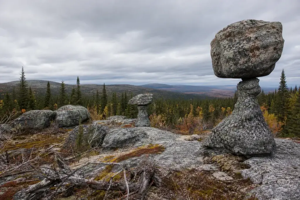
Mount Vottovaara stands 417.3 meters above sea level in central Karelia, the highest point of a remote upland plateau covered in birch forest and bog. The mountain takes its name from the Sami language: votto derives from a word meaning to conquer, and vaara means mountain.
What sets Vottovaara apart from any other peak in the region is its remarkable landscape of 1000 to 1500 seids and other stone constructions—balanced boulders, often propped on smaller stones in ways that seem almost deliberate, though their true origin remains debated. The plateau brings a different ecosystem: low-growing northern vegetation, dwarf birch and pine, and small clear lakes surrounded by silence.
Quick Facts
| Russian name | Гора Воттовара |
|---|---|
| Address | Sukkozero rural settlement, Muezersky District, Republic of Karelia Google MapsApple MapsYandex Maps2GIS |
| District | Muezersky |
| Admission | free |
| Best time to visit | Late May through September is the accessible season. Summer (June–August) offers the longest daylight but also the heaviest insect season; bring strong repellent. September brings clearer weather and fewer mosquitoes, though temperatures drop and daylight shortens. October can be wet and boggy; by November, snow and frozen ground can make hiking difficult, and daylight is severely limited. Winter (December–March) is possible for experienced hikers with cold-weather gear, but access road conditions are hazardous and days are very short. Spring (April–May) is usually muddy from snowmelt. |
| Recommended duration | 8–10 hours |
What Is (and Isn't) Part of a Visit to Mount Vottovaara, Karelia?
| Part | Status | Notes |
|---|---|---|
| Plateau and seids | Included in the standard ticket | The main mountain summit and boulder fields are open to hiking; no permit required, but the area is designated a natural monument. |
| Lake Eye | Included in the standard ticket | The small lake in the Amphitheater basin is accessible and part of the standard hiking route. |
| Staircase to the Sky | Included in the standard ticket | An optional extension on a neighboring ridge, 3 km from the main plateau; requires additional time and route-finding. |
| Forest trails and parking areas | Outside / not part of it | Approach roads and parking are not maintained facilities; they are rough forestry roads requiring suitable vehicles. |
| Guided tours or ranger services | Not open to visitors | No official visitor center, guide services, or interpretation facilities are provided; visits are independent hiking. |
Why Visit Mount Vottovaara, Karelia?
Vottovaara offers raw geological drama and genuine isolation. From the top are beautiful views of the Karelian taiga and lakes, and the plateau itself is an open landscape of rock, heather and stunted trees. The most striking features are propped boulders, sometimes called flying stones because of the way boulders are elevated by smaller stones, making them seem as if they are lifting into flight. The puzzle of how and why these formations exist has drawn researchers, hikers and those drawn to its mystique for decades. A full-day trek rewards visitors with one of northern Russia’s most distinctive and unsettling natural environments.
How Mount Vottovaara, Karelia Is Laid Out
The mountain is a ridge stretching in a submeridional direction for approximately 7 km, with a relatively flat summit plateau roughly 400 meters wide. The main access route climbs from the south side, rising from Lake Eye in the center of the Amphitheater on Mount Vottovaara, a swampy basin ringed with seids. From the southern approach, about 500 m along a narrow path, there are stones and tree root systems. Once on the plateau, visitors can walk north and south along the open ridge, following informal trails between the boulder fields. The famous Staircase to the Sky is located on the slope of a neighboring hill, 3 kilometers away from the Amphitheater, and along the way you will have to overcome a swampy area.
Highlights of Mount Vottovaara, Karelia
The Seids: Ancient Balanced Boulders
The mountain is a collection of prehistoric stone monuments called seids, which means hanging or flying stones. These formations—some as tall as a person—rest on precarious bases, creating an otherworldly landscape. Geologists attribute them to glacial weathering and post-glacial frost action, though debate persists about whether some show signs of human arrangement. What a visitor actually sees are scattered rocks of all sizes across the plateau, some balanced impossibly on narrow pedestals, others emerging from moss and heather. Look for the most spectacular clusters around the central and southern areas.
Tip: Most seids are concentrated on the plateau itself; the surrounding forest is dense and navigation can be confusing, so stick to the main paths or hire a guide for the Staircase to the Sky route.
The Summit Plateau
The top of Vottovaara is not a single peak but an open, wind-swept plateau with a 360-degree horizon. The surface of the mountain is overgrown with heather, in many places there are seids. From the highest point you see the Karelian taiga stretching in all directions, dotted with lakes reflecting gray sky. The vegetation here is distinctly northern—dwarf birch, stunted pine, mosses and lichens—different from the taller forest below, marking the shift in climate and soil.
Tip: Fog and mist can roll in quickly; bring a compass or GPS and stay aware of approaching weather, especially in autumn.
Lake Eye (Okoye)
Lake Eye in the center of the Amphitheater on Mount Vottovaara, in the center of a swampy area. This small, clear lake sits in a natural bowl surrounded by low rock walls and seids, marking the gateway between the taiga and the plateau above. Its name refers to the way it seems to gaze upward from within the mountain's amphitheater-like depression. The water is cold and acidic from surrounding peat.
Tip: The lake is a natural landmark for orientation; if you can see it, you know you are entering the main climbing section.
The Amphitheater
On the south side of the top of Mount Vottovaara there is a famous Amphitheater where you can see very picturesque clusters of stones and seids, and in the center is a swampy area and the Eye Lake. This natural bowl formation is where the plateau rises steeply, and the boulder formations are densest here, creating a dramatic landscape of tumbled geology.
Tip: This is the most photographed area; come early or late in the day to avoid groups of tourists if you visit in summer.
The Staircase to the Sky
The famous Staircase to the Sky is located on the slope of a neighboring hill, 3 kilometers away from the Amphitheater, and the steps are very smooth, it seems as if they are cut down by people. These natural rock formations on an adjacent ridge create an illusion of deliberate stone steps, adding to the mountain's reputation for unexplained phenomena. Reaching them requires a 3–4 hour trek from the central plateau across swampy ground.
Tip: This is an optional extension; it is not part of the main summit visit and requires planning an earlier start and more stamina. It is sometimes cited as the best photo spot on the mountain.
Dead Trees and Northern Ecology
There are many tree sprouts on the top of Mount Vottovaara, but the old trees are all dying. The plateau is covered in bleached, twisted deadwood from trees that could not compete with wind and poor soil. This stark landscape—living moss beneath dead branches—gives the mountain its haunting appearance and marks the edge of what trees can endure in this climate.
Tip: The deadwood makes footing tricky in places; wear sturdy boots with good ankle support.
Atmosphere
Vottovaara feels like stepping into a different world. The air is cool and often damp; wind moves constantly across the open ridge, especially in autumn and winter. On clear days the light is bright and almost harsh against gray-green moss and pale rock; on cloudy days the plateau dissolves into mist. Sounds are muted—wind, occasional bird calls, the soft crunch of heather underfoot. Few people venture here; if you encounter other visitors it is usually only at the main scenic spots. The absence of normal forest sounds (no dense bird chorus, no rustling undergrowth) contributes to a sense of solitude or, to some, unease. The deformed trees and balanced boulders create shapes that suggest intention or strangeness, which is why the mountain has accumulated legends of the supernatural.
History of Mount Vottovaara, Karelia
The Vottovaara mountain area is situated in the western wing of the Yangozero synclinorium, the second largest on the Karelian Craton. Vottovaara is characterized as a ridge, stretching in a submeridional direction for approximately 7 km, composed of Jotnian quartzites and quartzite-sandstones, fractured by numerous faults, possibly rejuvenated in the post-glacial period. The mountain is thus built on some of the oldest rock on Earth’s continental crust.
Mount Vottovaara is the highest point of the West Karelian Upland and the oldest place of worship—a sacred place of the ancient Sami. The seids are traditionally interpreted as markers of Sami ritual sites, with the stone arrangements serving as offerings to spirits or deities. However, modern geological interpretation emphasizes that the balanced boulders are largely the result of freeze-thaw weathering of the quartzite bedrock, with a lack of datable artifacts or conclusive evidence of modification of many formations.
The area remained remote and relatively untouched through the 20th century until its natural and cultural value became recognized. In August 2011, the Government of the Republic of Karelia declared the Vottovaara mountain complex a natural monument, placing more than 1,500 hectares under protection. The designation acknowledges both geological significance and the site’s cultural heritage as a Sami sacred place.
Legends and Myths about Mount Vottovaara, Karelia
The Incident of 1940
Legend – historically unreliable. Local folklore holds that during the Winter War in January 1940, a detachment of Soviet soldiers climbed Mount Vottovaara and disappeared. Finnish troops stationed nearby heard gunshots and commotion in the night, then silence. When they investigated, they found no trace of the soldiers. The legend persists in various forms across Karelian folklore, though historical documentation of the event is unclear. The story feeds into modern theories about the mountain as a place where normal rules do not apply.
The Mountain of Death
Legend – historically unreliable. In local Russian folklore, Vottovaara is known as Smertnaya Gora—Death Mountain. The name reflects superstitions that the place is spiritually dangerous, a site where people become disoriented, compasses fail, and technology malfunctions. Some stories speak of missing hikers and unexplained phenomena. While visitors do occasionally get lost or injured in the remote terrain, modern explanations are mundane: the area's remoteness, poor road access, and changeable weather make it genuinely hazardous, especially for unprepared visitors.
Portal to Another World
Legend – historically unreliable. Some contemporary accounts describe Vottovaara as a portal or thin place between worlds. Visitors report unusual energy, time distortion, and encounters with strange beings. These stories are part of modern esoteric and paranormal folklore rather than traditional Sami beliefs, though they draw on the mountain's reputation as a sacred Sami site. The isolation, otherworldly landscape, and abundance of unexplained stone formations provide fertile ground for such interpretations.
Tickets and Booking for Mount Vottovaara, Karelia
Mount Vottovaara has no ticketing system or entry fee. It is a free, public natural monument accessible to hikers year-round. There is no official website or booking platform; visits are entirely independent. No permits are required for day visits.
Access is via a rough forestry road from the nearest villages. The road from Medvezhegorsk or Girvas has low-quality asphalt surface, but then more than 100 kilometers is on a dirt road, and from the village of Gimoly to the mountain of Vottovaara is 20 kilometers. The road is navigable by car in summer and early autumn, but becomes impassable in winter or after heavy rain. It is strongly recommended to use a four-wheel-drive vehicle or arrange local transport from Gimoly or Sukkozero.
Cell phone coverage is unreliable or absent in the area. Carry a physical map or GPS device, and inform someone of your hiking plans and expected return time.
Plan and Book
Suggested itineraries Mount Vottovaara, Karelia
Day hike from parking
From the southern parking area near Lake Eye, ascend the narrow path through rocks and tree roots to the Amphitheater. Explore the seids and plateau for 3–4 hours. Descend the same route. Total time: 6–8 hours including rest. This is the standard day visit.
Extended day with Staircase
Follow the day hike route to the plateau. After exploring the Amphitheater, continue north along the ridge for 1–2 km, then depart westward toward the Staircase to the Sky (3 km of bog and rough terrain). Return the same way. This requires an early start and 10–12 hours total, including navigation time. Only for experienced hikers.
Multi-day trek
Stay overnight in a wilderness camp near the mountain (no facilities provided). This allows full exploration of both sides of the plateau, the Staircase, and the surrounding forest. Organized trekking companies offer 3–6 day itineraries that combine Vottovaara with nearby sites such as the Suna River and Girvas volcano.
How to Get to Mount Vottovaara, Karelia
By car from Petrozavodsk: Follow the highway south toward Medvezhegorsk. After Girvas (approximately 160 km), turn onto the forestry road toward Gimoly. The road becomes rough gravel; allow 3–4 hours from Medvezhegorsk. From Gimoly, continue east on the dirt road for approximately 20 km to parking areas near the base of the mountain. A four-wheel-drive vehicle is strongly recommended.
By train: You can get from St. Petersburg to the village of Gimoly by train, and from the village of Gimoly to the mountain of Vottovaara is 20 kilometers. Arrange local transport (taxi, guide, or local hire) from Gimoly; hiking the full distance is possible but adds 6–8 hours to the journey.
From Sukkozero: The village of Sukkozero to the north can also serve as a base, with the mountain located 20 km southeast. Roads in both directions are rough forestry roads.
No public bus service reaches the mountain. Plan transportation in advance through a local tour operator or guide service.
Accessibility
Mount Vottovaara is not accessible for wheelchair users or those with limited mobility. The terrain is rugged: from the southern site to the plateau, about 500 m along a narrow path, there are stones and tree root systems. The ascent involves scrambling over rocks and exposed tree roots. Uneven ground, exposed roots, and sudden drops make the plateau hazardous for anyone unable to maintain balance on uneven terrain. There are no railings, steps, benches, or facilities. The approach road is impassable for ordinary cars and rough for most vehicles. No ranger or assistance services are available on site.
Food Nearby
There are no food vendors, cafes, or water sources on Mount Vottovaara. The nearest villages, Gimoly and Sukkozero, are 20+ km away and have very limited services. Carry all food and water for the day. A lightweight stove and freeze-dried meals are practical for multi-day visits. Expect no restaurants or shops within reasonable distance of the mountain itself; prepare in Petrozavodsk or another larger town before heading to the area.
What to Bring
Sturdy waterproof hiking boots with good ankle support (essential for rocky ground and tree roots). Warm layers: Karelia's weather is unpredictable and wind is constant on the plateau. A windproof jacket and hat are necessary even in summer. Rain gear. Stock up on repellents for mosquitoes below and horseflies on the mountain during your visit. A physical map, compass, or GPS device (cell coverage is unreliable). Plenty of water and high-energy snacks. A headlamp for early starts or late finishes. Sun protection: the plateau is exposed and reflection off pale rock is intense. A small first-aid kit. For winter visits, full cold-weather and avalanche safety gear. No special permits are needed; carry your passport (you are in a remote border region).
Best Views and Photo Spots of Mount Vottovaara, Karelia
The Amphitheater rim looking south
From the upper edge of the Amphitheater facing south, the rock walls and seids create layered, sculptural forms; the small lakes visible below frame the composition. The balanced boulders are silhouetted against the sky. Heather and moss add texture.
Best time: Late afternoon (4–5 pm) for warm light and long shadows that highlight the boulder shapes. Early September offers clarity without summer haze.
Lake Eye from the western rim
Looking down into the Amphitheater basin, the small clear lake reflects gray sky, surrounded by a ring of seids and low rock walls. The contrast between the water and the surrounding stone is stark. The surrounding bog and forest form the backdrop.
Best time: Midday (11 am–1 pm) when the sun is high enough to illuminate the water and reduce reflections. Autumn, when the taiga begins to change color.
The plateau looking north from the central high point
An unobstructed 360-degree horizon: open ridge with scattered boulders and deadwood, taiga forest receding toward Finland, and distant lakes visible on clear days. The sense of isolation and scale is palpable.
Best time: Clear, low-light conditions at sunrise or sunset. Late August through September for clarity and crisp air without haze.
Seids in late afternoon sunlight (central plateau)
Individual or small clusters of balanced boulders backlit or side-lit by low sun. The shadows beneath the overhanging stones emphasize their precarious balance. Moss glows greenish-gold in warm light.
Best time: 4–6 pm in summer, 2–4 pm in autumn. Avoid midday when light is flat and shadows are minimal.
The Staircase to the Sky (optional)
A series of natural rock ledges resembling carved steps on the slope of a neighboring ridge, leading upward into the mist or clear sky. The regularity of the formations creates an almost architectural composition.
Best time: Morning (9–11 am) when light is fresh and mist may still cling to the surrounding forest, adding mystery. Requires a 3 km trek from the main plateau.
Photography Rules
Photography is unrestricted. The landscape offers dramatic light and color, especially in early morning or late afternoon when shadows define the boulder formations and the plateau glows. The principal challenge is exposure metering on pale rock and bright moss. Use a lens hood to reduce glare. Drones are not explicitly banned but operate in a remote, sensitive border area; check with local authorities before flying. No tripod restrictions, but the ground is uneven and rocky, making stable placement difficult.
Family Suitability
Mount Vottovaara is suitable only for families with children ages 12 and above, and only with good fitness and experience on rough terrain. The ascent requires scrambling over rocks and exposed tree roots, with uneven footing and exposure. From the southern site to the plateau, about 500 m along a narrow path, there are stones and tree root systems; if you are tired or unwilling to continue the route, a tourist can independently go down the trail to the foot of the mountain. Younger children, those lacking hiking experience, or anyone with weak ankles should not attempt the climb. Strollers and carriers are impossible on the rough approach road and ascent. The 20+ km dirt road approach and remote location make this an expedition requiring significant preparation, not a casual day trip. Families with young children should consider alternative hiking destinations nearer to Petrozavodsk.
Russia Vibes Tips
- Start very early in the day. Plan your departure no earlier than 5–6 pm, which means departing the parking area by 8–9 am to allow 8 hours of daylight and margin for delays. Daylight is limited in autumn, and the rough terrain is hazardous in poor light.
- Expect no cell service. Download a map of the area beforehand and carry a compass. GPS devices are helpful but not reliable everywhere in the terrain due to dense tree cover and proximity to terrain that causes multipath errors.
- The access road requires careful driving. If your car is not suited to rough, muddy tracks, arrange pickup from Gimoly or Sukkozero through a local guide or tour operator rather than attempting to drive alone. Getting stuck or breaking down in a remote area has serious consequences.
- Bring more repellent than you think necessary. Even in late summer, horseflies on the plateau and mosquitoes in the taiga below are relentless. Pack spray, lotion, and head net if possible.
- The landscape is disorienting. Paths are informal and the boulder fields can look identical. Mark your route mentally or with small stones, or hire a local guide for areas beyond the main plateau, especially if attempting the Staircase to the Sky.
- The plateau is exposed and windy; weather changes rapidly. What looks clear in the morning can become foggy by afternoon. Turn back if visibility drops or light fails, rather than press on to distant features like the Staircase.
Explore Nearby Mount Vottovaara, Karelia
Browse more: More in Muezersky · All Karelia · All Landmarks · All Sightseeing · All Sightseeing in Karelia
FAQ: Mount Vottovaara, Karelia
Is Mount Vottovaara difficult to climb?
The ascent is moderate in technical difficulty but physically demanding. From the southern site to the plateau, about 500 m involves stones and tree root systems and requires scrambling over rough ground. The main route is not dangerous if you are fit and careful, but it is not a walk. The access road is harder than the climb itself—rough dirt requiring a suitable vehicle.
How long does it take to hike Mount Vottovaara?
The ascent and route take about 8 hours, and the distance is about 11 kilometers. This is the time for a day hike from parking area to plateau and back, including rest and exploration. The Staircase to the Sky adds 3–4 hours one-way. Plan to start before 9 am to finish before dark.
What are seids and why is Vottovaara covered in them?
Seids are prehistoric stone monuments that mean hanging or flying stones. Vottovaara has 1000 to 1500 of them. Geologists explain most as products of glacial weathering and freeze-thaw action on quartzite bedrock. It is a sacred place of the ancient Sami, and traditions view them as ritual markers, though there is a lack of datable artifacts or conclusive evidence of modification for most formations.
Is it possible to visit Mount Vottovaara without a car?
Yes, but with difficulty. You can get from St. Petersburg to the village of Gimoly by train, and from the village of Gimoly to the mountain of Vottovaara is 20 kilometers. From Gimoly, hire a local taxi or guide, or hike the road (6–8 hours), which is longer than the mountain climb itself. Arrange transport and guides in advance.
When is the best time to visit?
Late May through September is accessible. September offers clearer weather, fewer insects, and fewer crowds than summer. June to August has longest daylight but heavy mosquitoes and horseflies. October becomes wet and dangerous. Winter is possible only for expert hikers with full gear and short daylight hours.
Are there guided tours?
No official ranger-led tours operate from the site. Local tour companies in Petrozavodsk and Karelia offer 2–3 day guided expeditions to Vottovaara as part of broader Karelia itineraries. These are useful if you lack a vehicle or prefer not to navigate alone. Private guides can be arranged in advance through tourism offices in Petrozavodsk.
Is it safe to visit alone?
Technically yes, but remote location, rough terrain, unreliable cell coverage, and changeable weather make solo visits risky, especially for first-timers. A guide or companion is strongly advised. Hikers should file a detailed itinerary with someone who will raise an alarm if you do not return on time.
Can I camp overnight at Mount Vottovaara?
Yes, wild camping is permitted on the plateau and nearby. There are no facilities—no water sources, toilets, shelters, or marked campsites. Carry all water and equipment. Leave no trace. Multi-day trekking companies provide base camps or arrange logistics. Winter camping is only for experienced mountaineers with proper gear.
Russia Vibes is a one-person project. A coffee keeps it going
How we research and update our guides
About this guide: AI assistance and accuracy
This guide is created with the help of AI and is based on official sources where available. Mistakes can still happen. Opening hours, prices, rules and other details are given to the best of our knowledge as of the date shown and can change without notice. It offers general recommendations only, not professional, legal or travel advice. Please confirm important details with the official source before you travel; you are responsible for your own plans and decisions.
Packing for this trip
* Affiliate link: as an Amazon Associate we earn from qualifying purchases at no extra cost to you.

Take this guide with you
Get a free PDF of this guide to print or read offline: key facts, tips and a map link on a few clean pages.
Report an issue on this page
Paying for your trip: please read
International sanctions affect payments between Russia and many other countries. In practice, cards issued in the EU, the UK, the US and several other countries often do not work in Russia, Russian cards usually do not work abroad, and some booking platforms, airlines and payment providers limit or suspend their services for Russia. The situation changes frequently.
We do not give legal or financial advice, and this site does not encourage anyone to break or circumvent sanctions. Whatever you plan, you are responsible for following the laws and regulations that apply to you, including those of your country of residence and citizenship.
Many travelers still organise their stay lawfully. It is worth asking your bank or payment provider what is currently permitted, contacting hotels, tour operators and carriers directly about the payment methods they accept, and checking which services are open to customers from your country. Clarify payment, cancellation and refund terms before you commit to a booking, and keep your plans flexible.
Partner links on this site may not be available in every country, and prices, availability and rules in our guides can differ from what you see when you book.