
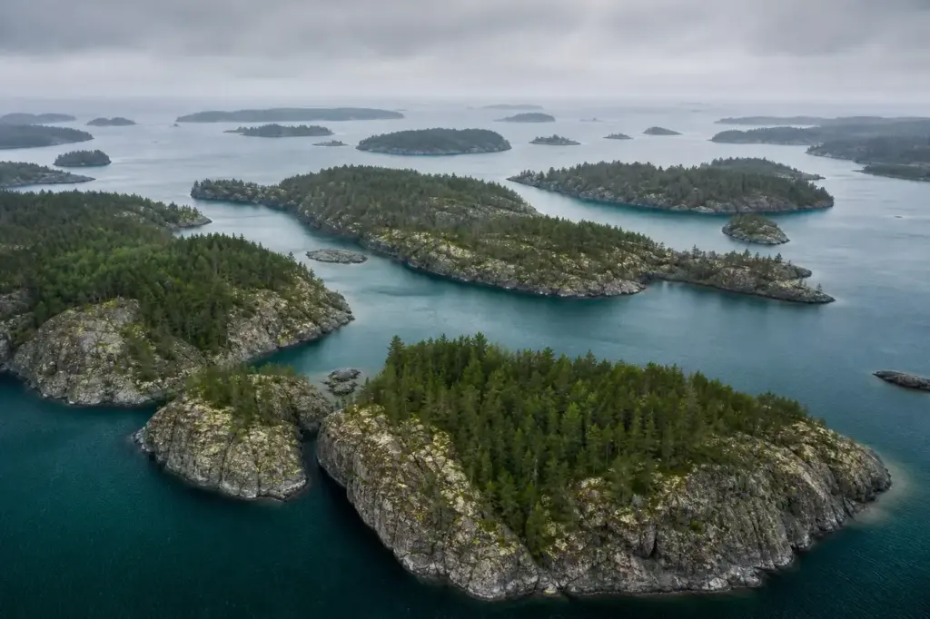
Ladoga Skerries National Park is located on the north and northwestern shores of Lake Ladoga in the Republic of Karelia. The park protects approximately 122,000 hectares of islands, skerries, and surrounding waters where ancient granite bedrock, sculpted by glaciers, creates thousands of rocky islands, narrow channels, and sheltered bays.
This destination in Russia’s Republic of Karelia was officially established in 2017 after decades of conservation efforts, preserving a unique ecosystem found nowhere else on the continent. The nature is similar to that in southwestern Finland and resembles Norwegian fjord landscapes—there is nothing like it elsewhere in Russia or in the Nordic countries.
Quick Facts
| Russian name | Национальный парк «Ладожские шхеры» |
|---|---|
| Built / opened | 2017 |
| Address | Lakhdenpokhsky, Sortavalsky, and Pitkyarantsky districts, Republic of Karelia Google MapsApple MapsYandex Maps2GIS |
| District | Karelia |
| Best time to visit | The northern part of the lake is wilder, with secluded rocky coves and dense forested areas of coniferous trees. Summer (June to August) offers the longest daylight, warmest water for swimming, and active wildlife. May and early June bring migrants and nesting birds. Autumn (September to October) brings brilliant forest colors and fewer visitors. Winter freezes the lake, allowing ice travel but requiring specialized equipment and experience. Spring (April to May) is cold and unpredictable. July and August can be crowded at accessible sites, while mid-June and September offer better solitude. |
| Recommended duration | 3–7 days |
What Is (and Isn't) Part of a Visit to Ladoga Skerries National Park, Karelia?
| Part | Status | Notes |
|---|---|---|
| The skerries archipelago and islands | Included in the standard ticket | The park protects over 650 rocky islands and the surrounding waters. |
| Forest areas on islands | Included in the standard ticket | Old-growth boreal forests and mixed forest ecosystems across the islands are part of the protected area. |
| Lake Ladoga waters within park boundaries | Included in the standard ticket | The waters surrounding the islands within the park's 122,000 hectares are protected. |
| Valaam Archipelago | Separate ticket or institution | Valaam and its monastery are nearby and adjacent but form a separate protected area with its own rules and administration. |
| Lodging and permanent facilities | Not open to visitors | The park has minimal developed infrastructure; camping and remote exploration dominate. |
| Roads and vehicle access | Outside / not part of it | The park is accessible only by water; no roads connect the islands. |
Why Visit Ladoga Skerries National Park, Karelia?
The islands support diverse forest ecosystems ranging from pine-dominated rocky outcrops to rich mixed forests. The lake waters and islands provide essential habitat for breeding waterfowl, migrating birds, and the critically endangered Ladoga seal.
The park is a unique network of long and narrow fjord-like bays and straits and islands. The highest ones, the reef islands with steep walls, rise up to 80 metres, with hundreds of islands, almost a hundred small lakes and nearly 1,000 kilometres of unbuilt shoreline.
Highlights of Ladoga Skerries National Park, Karelia
The Skerries Archipelago
The archipelago of 650 islands that makes up the Ladoga Skerries begins near the village of Berezovo, on the border of the Leningradsky region and Karelia, then stretches for 170 kilometres north to Pitkyaranta. The islands are rocky, granite outcrops shaped by ancient glaciation, creating a landscape of narrow channels, small bays, and forested ridges. Each island offers different terrain and forest types. The scale and density of islands create a maze-like waterscape that changes constantly as you move through the park.
Tip: Hire a local guide or boat operator familiar with the channels; the labyrinth of straits can be confusing without local knowledge.
Granite Formations and Geology
The park's distinctive landscape was formed during the last ice age, when glacial activity carved out the characteristic skerries. The bedrock consists primarily of ancient Precambrian granite and gneiss, dating back approximately 2 billion years. The highest reef islands with steep walls rise up to 80 metres. These dramatic rock faces and polished granite surfaces show the power of glacial carving; many boulder fields scattered across islands are glacial erratics.
Tip: Look for glacial scratches and striations on exposed rock faces; they show the direction the ancient ice sheets moved.
Forest Ecosystems and Wildlife
The tree stand is highly diverse, including old-growth forests with numerous threatened and rare species. Pine, spruce, and birch grow on the rocky islands, with dense forests in sheltered valleys. The threatened Lake Ladoga ringed seal has a viable population in the area. Waterfowl, eagles, and osprey are common. The forests are home to brown bears, elk, and lynx on the larger islands and mainland.
Tip: Visit in summer for breeding bird activity; bring binoculars for seal-watching from boat channels early in the morning.
Narrow Bays and Channels
The National Park is a unique network of long and narrow fjord-like bays and straits with hundreds of islands and nearly 1,000 kilometres of unbuilt shoreline. Some channels are only a few metres wide, creating an intimate sense of passage between towering granite walls. The quiet waters of protected bays contrast sharply with the open waters of Lake Ladoga. This intricate geography creates multiple micro-habitats.
Tip: Explore by kayak or canoe to access narrow passages and hidden coves that larger boats cannot reach.
Valaam Monastery Complex
An integral part of these skerries is the famous Valaam Archipelago, where the ancient monastery, also called Valaam, is located. It can rightfully be regarded as the spiritual heart of the Russian nation. The Valaam archipelago lies within the northern portion of Lake Ladoga with more than 50 islands with a total area of 36 km². The largest island is also called Valaam. This is a protected heritage site with historic structures and operating monastic community.
Tip: Valaam is technically adjacent to but not formally part of Ladoga Skerries National Park; check current rules for visitation and access.
Unbuilt Shoreline and Pristine Nature
There are nearly 1,000 kilometres of unbuilt shoreline in the area. Unlike many populated lake regions, the Ladoga Skerries remain relatively undeveloped. Remote beaches, rocky coves, and forested peninsulas are largely untouched. The absence of roads and heavy infrastructure preserves the wilderness character. The clear waters and minimal pollution make this one of the cleanest freshwater environments in the region.
Tip: Pack camping equipment; there are few permanent facilities, and much of the park is wilderness accessible only by water.
Atmosphere
The rugged beauty of the granite skerries, clear waters, and forested islands creates landscapes reminiscent of marine archipelagos though located entirely within a massive freshwater system. The park feels remote and wild, with the sounds of water lapping against rock and birds calling across the channels. In summer, the light lingers late into the evening. Mist often rises from calm bays in early morning, creating a mystical atmosphere. The winding passages between islands create a sense of discovery; each turn reveals new granite formations and hidden coves. Few people are visible, even in peak season, lending a sense of solitude and timelessness to the experience.
History of Ladoga Skerries National Park, Karelia
The Lake Ladoga Skerries National Park was officially established in 2017, though the area has been historically significant for centuries. The region has been inhabited since ancient times by Karelian and Finnish peoples, with evidence of human settlement dating back to the Neolithic period.
The skerries area played an important role in medieval trade routes between Scandinavia and Novgorod. The narrow channels and islands provided natural passages for merchant vessels and warriors moving through Northern Europe. The region’s position at a crossroads of cultures left marks of both trade and conflict.
During World War II, the region saw significant military activity as part of the Soviet-Finnish front. On these islands during the Second World War, there was a defensive line, and then a secret research base. The war brought fortifications and strategic installations to the islands, remnants of which still stand hidden in the forests.
The earliest proposal for creation of a national park was proposed by Karelian Research Centre of RAS in late 1980s. However, the project was stalled due to reasons such as close proximity in Sortavala and presence of various country houses. For decades, conservationists and outdoor enthusiasts advocated for protected status. The reason for creating the park is to preserve the unique natural complexes of the Ladoga Lake skerries that have no analogue in Russia and Europe. The park was officially established on December 28, 2017.
Legends and Myths about Ladoga Skerries National Park, Karelia
The Ladoga Seal's Ancient Lineage
Legend – historically unreliable. The threatened Lake Ladoga ringed seal has a viable population in the area. Local folklore tells of seals as guardians of the deep waters, connected to spirits of the lake that predate human settlement. Ancient Karelian peoples regarded seals as sacred messengers between the surface world and the depths below. These rare freshwater seals have survived in isolation for thousands of years, their presence in the skerries seen by locals as proof of the waters' ancient power and sanctity.
Hidden Channels of the Spirits
Legend – historically unreliable. The intricate maze of narrow channels and hidden bays gave rise to tales among Finnish and Karelian peoples of spirit passages—routes known only to those the waters favored. Fishermen and traders spoke of certain channels that seemed to shift or disappear, reappearing only for those with the proper knowledge or blessing. Some believed the archipelago was deliberately hidden by protective spirits to preserve it from harm, and that only those pure of heart could navigate safely.
Plan and Book
Suggested itineraries Ladoga Skerries National Park, Karelia
2–3 days
Base yourself in Sortavala or Lahdenpohja. Hire a guide and boat for a day tour exploring the central skerries, viewing granite formations and channels. Return for an evening of rest. Spend the second day kayaking or canoeing through narrow bays, observing forest ecosystems and wildlife. On the third day, visit a larger island to explore its interior forests and viewpoints before returning to shore.
5–7 days
Undertake a multi-day camping expedition with a guide and boat support. Day 1: travel to a remote island and establish camp. Days 2–4: explore surrounding islands, paddle channels, search for seals and birds, and experience the wilderness. Days 5–6: venture to new islands, climb granite formations for views, and visit hidden coves. Return to shore on the final day.
Day trip
Depart from Sortavala in the morning for a guided boat tour of accessible skerries. Explore the granite landscape, observe wildlife, and stop for swimming or beach time. Return by evening. Suitable for visitors with limited time or those not equipped for camping.
How to Get to Ladoga Skerries National Park, Karelia
Ladoga Skerries National Park is located in northwestern Russia, approximately 270 km (168 miles) from St. Petersburg. The nearest major town is Sortavala, which serves as the gateway to the park.
From St. Petersburg, travel northeast by car or marshrutka (shared minibus) to Sortavala, a journey of 4–5 hours. Sortavala is the main hub for arranging boat access and hiring local guides. Alternative gateway towns include Lahdenpohja (Lakhdenpokhya) to the south and Pitkyaranta to the north.
Once in Sortavala, arrange boat hire or a guided tour through local operators. There is no public ferry service into the park; private boats and organized tours are necessary. Camping equipment and provisions must be brought from the mainland or arranged in advance.
Accessibility
The park is primarily accessible by water and is not wheelchair-friendly. There are no paved paths or developed infrastructure. Remote islands require climbing rocky terrain and navigating uneven ground. Visitors must be comfortable in boats and capable of basic self-sufficiency. Swimming ability is advisable due to water exposure. Large boulders and rocky beaches are common.
Food Nearby
Sortavala and Lahdenpohja have cafés and small restaurants serving Russian and local cuisine. Bring all camping food and cooking equipment if planning backcountry expeditions; supplies are not available on the islands. Local markets in gateway towns stock basic groceries. Plan meal provisioning carefully before departure.
What to Bring
Waterproof camping gear, sturdy hiking boots, warm layers (weather changes rapidly), insect repellent (heavy in summer), water purification method or bottles, first aid kit, map and compass or GPS, fire-starting materials, food provisions, cooking equipment. Summer temperatures range from 10–20°C; prepare for rain and wind. Swimwear, sunscreen, and hat are essential. Leave valuables on the mainland.
Best Views and Photo Spots of Ladoga Skerries National Park, Karelia
Granite cliff faces overlooking narrow channels
Steep granite walls rise 60–80 metres above water channels, creating dramatic vertical compositions. The bare rock faces catch morning light beautifully, showing glacial striations and color gradations in the stone.
Best time: Early morning light (6–8 AM in summer) illuminates east-facing cliffs; late afternoon light suits west-facing walls. Avoid midday glare reflecting off water.
Hidden cove with pine forest framing
Sheltered bays ringed with dense coniferous forest on rocky shores create intimate, framed compositions. The contrast between dark green forest and light granite creates striking color contrast.
Best time: Overcast days reduce glare and bring out forest greens; early morning mist adds atmosphere. Visit in June for white nights or September for autumn tones.
Island shoreline at sunset
Rocky beaches and granite outcrops silhouetted against soft evening light over the open water. The interplay of warm light, cool water, and dark land masses creates balanced compositions.
Best time: Late June through August for extended twilight; aim for 20:00–22:30 for peak color. July offers the longest light window.
Water-level perspective through narrow strait
Paddling at water level through tight channels reveals the scale of surrounding granite walls and creates a sense of immersion in the landscape. The narrow passage frames distant islands.
Best time: Any calm morning; glassy water reflects sky and rocks, creating mirror-like surfaces. Avoid rough weather.
Photography Rules
The National Park is a unique network of long and narrow fjord-like bays with nearly 1,000 kilometres of unbuilt shoreline, with nature similar to that in southwestern Finland and resembling Norwegian fjord landscapes. No specific restrictions on photography are published, but respect nature and wildlife. Drones, tripods, and commercial filming may require permission from park administration. Bring weatherproof camera protection.
Family Suitability
The park is suitable for older children and teenagers with outdoor experience, but challenging for young children due to remote access, lack of facilities, and water-based travel requirements. Families with infants or toddlers should visit the shore areas near Sortavala instead. Teenagers can handle multi-day camping expeditions with proper supervision. Swimming is possible but water temperatures remain cold even in summer. Strollers are not practical; backpack carriers are necessary on the islands.
Russia Vibes Tips
- Arrange your guide and boat weeks or months in advance, especially for summer expeditions. Local operators based in Sortavala know the channels, safety protocols, and weather patterns essential for safe navigation.
- The park has minimal permanent infrastructure. Do not assume you will find water, food, or shelter on the islands. Bring or arrange all supplies before departure from the mainland.
- Weather can change rapidly from calm to rough; respect water conditions and avoid crossing open lake waters in high winds. Seek shelter in protected channels or bays if conditions deteriorate.
- Mosquitoes and other biting insects are severe in June and July, especially in still, forested areas. Bring high-quality insect repellent and consider long sleeves for dawn and dusk.
- Visit outside July and August to avoid crowds at accessible sites and to enjoy calmer weather. Late June and early September offer excellent conditions with fewer visitors.
- Pack a detailed map, compass, and GPS device. The countless channels and similar-looking islands make navigation challenging; do not rely on memory or verbal directions alone.
Explore Nearby Ladoga Skerries National Park, Karelia
Related guides
 Karelia: Best Places, Lakes, Islands and Travel Tips
Main image: AI-generated illustration. It may not show the place exactly as it looks.
 Lake Baikal: Where to Go, What to See and How to Visit
Main image: AI-generated illustration. It may not show the place exactly as it looks.
Browse more: More in Karelia · All Karelia · All Parks · All Sightseeing · All Sightseeing in Karelia
FAQ: Ladoga Skerries National Park, Karelia
Is the Ladoga Skerries National Park the same as Valaam?
No. Valaam is an adjacent archipelago with its famous monastery, but it is administratively separate. Both are in Lake Ladoga and nearby, but Valaam has its own protected status and different rules. You may visit Valaam separately, but check current regulations.
Can I visit the park on a day trip from St. Petersburg?
Yes, as a day trip from Sortavala (the main gateway), but a full day trip from St. Petersburg is exhausting, requiring 4–5 hours travel each way. Base yourself in Sortavala for at least one night to maximize park time.
Are there hotels or lodges inside the park?
No. The park has no developed facilities. You must camp on islands, stay in Sortavala or nearby towns, or arrange accommodation with a tour operator. Bring your own camping gear.
How many islands are in the park?
Over 650 rocky islands (skerries) make up the archipelago across the park's 122,000 hectares. Each island varies in size, from small outcrops to larger forested ridges.
Can I kayak through the park alone?
Kayaking is possible, but local guide knowledge is valuable for safe navigation through narrow channels and for understanding weather and current patterns. Solo kayaking without local guidance is risky due to the maze-like geography and rapidly changing conditions.
What wildlife might I see?
Waterfowl, eagles, osprey, and the rare Ladoga ringed seal inhabit the area. Brown bears, elk, lynx, and moose live on larger islands and mainland. Birds are most active during breeding season (May–July). Seals are most visible from boats in early morning or evening.
Is there a visa or permit required to visit?
As a Russian national park, standard Russian visa rules apply to international visitors. Check the official Russian government website for current requirements. No separate park permit is required beyond entry to Russia itself.
What is the best season to visit?
Summer (June–August) offers the longest daylight and warmest conditions, but July is busiest. September offers excellent weather and fewer visitors. Spring and autumn migrations bring birdwatchers. Winter access requires ice travel and specialized equipment.
Russia Vibes is a one-person project. A coffee keeps it going
How we research and update our guides
About this guide: AI assistance and accuracy
This guide is created with the help of AI and is based on official sources where available. Mistakes can still happen. Opening hours, prices, rules and other details are given to the best of our knowledge as of the date shown and can change without notice. It offers general recommendations only, not professional, legal or travel advice. Please confirm important details with the official source before you travel; you are responsible for your own plans and decisions.
Packing for this trip
* Affiliate link: as an Amazon Associate we earn from qualifying purchases at no extra cost to you.

Take this guide with you
Get a free PDF of this guide to print or read offline: key facts, tips and a map link on a few clean pages.
Report an issue on this page
Paying for your trip: please read
International sanctions affect payments between Russia and many other countries. In practice, cards issued in the EU, the UK, the US and several other countries often do not work in Russia, Russian cards usually do not work abroad, and some booking platforms, airlines and payment providers limit or suspend their services for Russia. The situation changes frequently.
We do not give legal or financial advice, and this site does not encourage anyone to break or circumvent sanctions. Whatever you plan, you are responsible for following the laws and regulations that apply to you, including those of your country of residence and citizenship.
Many travelers still organise their stay lawfully. It is worth asking your bank or payment provider what is currently permitted, contacting hotels, tour operators and carriers directly about the payment methods they accept, and checking which services are open to customers from your country. Clarify payment, cancellation and refund terms before you commit to a booking, and keep your plans flexible.
Partner links on this site may not be available in every country, and prices, availability and rules in our guides can differ from what you see when you book.