
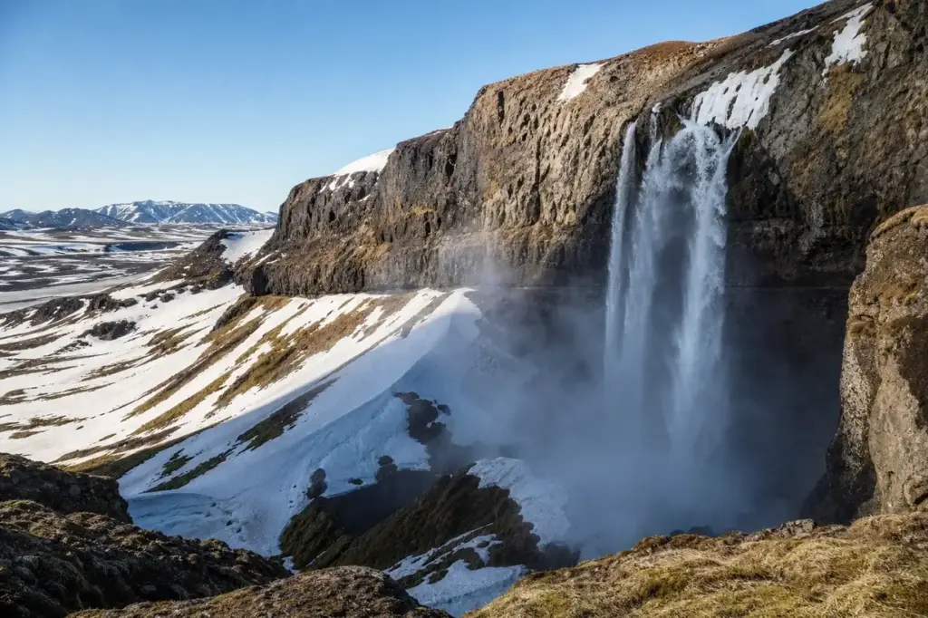
The waterfall is considered one of the most visited in Kamchatka, as it is located just 40 km from Petropavlovsk-Kamchatsky. Vilyuchinsky waterfall sits on the north-western slope of the dormant Vilyuchinsky volcano, a 2,173-metre stratovolcano in the southern Kamchatka Peninsula.
The waterfall is formed by melting of a glacier on the slopes of the volcano. The waterflow falls down from a cliff 60 metres high and goes into the icy abyss. The waterfall’s character changes dramatically with the seasons: in summer it flows freely beneath mist and spray, while in winter it freezes into a solid ice cone.
Quick Facts
| Russian name | Вилючинский водопад |
|---|---|
| Address | Yelizovskiy District, Kamchatka Krai Google MapsApple MapsYandex Maps2GIS |
| District | Kamchatka Krai |
| Admission | free |
| Best time to visit | The summer season for waterfall visits runs June to September. July and August offer the most stable weather and longest daylight, though brief afternoon rains are common. In summer the waterfall is chilly and scenic: mountain flowers and mosses grow on the rocks under ice-cold splashes of water. Winter (December–May) is optimal for viewing the frozen ice cone, but requires snowmobile transport and cold-weather gear. Late May and early September have fewer tourists but less predictable weather. Avoid April–May when snow melt creates muddy conditions on the lower road. |
| Recommended duration | 2–3 hours |
What Is (and Isn't) Part of a Visit to Vilyuchinsky Waterfall, Kamchatka Peninsula?
| Part | Status | Notes |
|---|---|---|
| Waterfall hike to the 40-metre drop | Included in the standard ticket | Free access via hiking trail from the foot of the volcano. Approximately 30 to 90 minutes uphill depending on pace and snow conditions. |
| Vilyuchinsky volcano itself (full ascent) | Separate ticket or institution | Climbing to the summit requires mountaineering experience and is not included in waterfall visits. Routes are classified 1B to 2B in difficulty. |
| Upper-Paratunka thermal springs | Separate ticket or institution | Located on Goryachaya Hill, a separate attraction sometimes combined with waterfall tours but requires separate arrangement. |
| Karymshinskiye Hot Springs | Outside / not part of it | Located 90 km away in a different valley; a separate day trip often paired with the waterfall in combination tours. |
| Vilyuchinsky Pass viewpoint | Outside / not part of it | A scenic overlook on the road near the volcano, sometimes visited as part of longer tours but not part of the waterfall hike itself. |
Why Visit Vilyuchinsky Waterfall, Kamchatka Peninsula?
The waterfall attracts many tourists, especially for its accessibility—getting to this point does not take much time and it’s easy. By car you can drive up to the foot of the volcano, but to the falls you have to go on foot. The hike itself is straightforward and suitable for visitors of varying fitness levels.
In summer it is chilly and scenic near the waterfall: mountain flowers and mosses grow on the rocks under ice-cold splashes of water, and the slope offers the view of the valley of the Paratunka River. In winter the waterfall freezes entirely and turns into an ice cone, which is visible from the bottom of the volcano.
Highlights of Vilyuchinsky Waterfall, Kamchatka Peninsula
The 40-Metre Drop
Melting glaciers and snowfields form a stream that falls from a vertical cliff of height 40 metres. The waterfall plunges into a mist that partially disperses before reaching the bottom, leaving you uncertain of the true depth. On clear days, the gradient of the slope and the valley below come into sharp focus.
Tip: Approach the water's edge carefully in summer—glaciers are fragile and water-carved holes can be concealed by overhanging ice. Do not lean over the edge to see into the crevasse beneath.
The Glacier Hole
The hole which the water pierces in the glacier can be up to 7 metres in diameter. You want to go to the edge of this hole to see the bottom, but it is not safe to do so—in summer the glacier becomes fragile. The hole is visible from certain vantage points on the approach trail.
Tip: Photograph this feature from a safe distance and observe it from the trail rather than attempting to reach its edge.
Winter Ice Formation (Tsar Icicle)
In winter the waterfall freezes entirely and turns into an ice cone. A huge ice cone of the frozen Vilyuchinsky Waterfall reaches 60 metres high. The frozen structure is visible from the foot of the volcano and creates a dramatic contrast against the surrounding snowfield.
Tip: Winter visits require appropriate gear and snow transportation. Tours are available via snowmobile or sled from December to May. Be aware that ice formations are unstable and can collapse without warning.
Forest and Dwarf Pine Belt
The first part of the road passes through the forest. This is a very popular place and the path is clearly visible. The forest has a dwarf birch and shrubs. The trail transitions from dense forest to open volcanic terrain as you climb.
Tip: Even in summer, the lower forest section can be muddy. Wear sturdy hiking boots and gaiters to keep debris out of your shoes.
Volcanic Landscape Above the Forest
Along the way you meet volcanic bombs—stoned blocks of lava ejected from the crater of the volcano more than 8,000 years ago. The upper reaches of the trail cross an open volcanic snowfield with views across the valleys and ridges.
Tip: The snowfield is visible for kilometres. If you lose the trail among rocks and snow, head upslope toward the sound of falling water.
View of Paratunka Valley
The slope offers the view of the valley of the Paratunka River. From the waterfall location, you can see across the broad valley toward distant mountains and the Pacific coast beyond.
Tip: The best panoramic views are from the upper snowfield before you reach the waterfall. Stop and take photos on the way up as well as on the way down.
Atmosphere
The higher the road goes, the snowier it gets. Closer to the waterfall, you will be walking on a wide white field—snow is here all year round. In summer, the waterfall roars with meltwater, and visitors feel the cold spray even from a distance. The landscape is starkly beautiful: bare volcanic rock, patches of dwarf vegetation, and permanent snow in the shadow of the cliff. In winter, the silence is profound, broken only by wind and the creaking of ice. The frozen waterfall glows white against a grey sky, and visitors move carefully across the slippery snowfield. On a clear day, the scale of the volcano and surrounding terrain is overwhelming; on overcast days, the landscape feels intimate and claustrophobic.
History of Vilyuchinsky Waterfall, Kamchatka Peninsula
Vilyuchik is a dormant stratovolcano in the southern part of the Kamchatka Peninsula. The volcano itself is ancient and dormant, its last confirmed eruption occurring around 8050 BCE. Vilyuchik has the correct form of a cone, its slopes are cut by deep ravines descending from the summit, this indicates that the volcano has died out for a very long time. The waterfall itself is a recent feature in geological terms, appearing each year when the volcanic glacier melts. As those glaciers melt in warm weather months, their runoff trickles through the mountains, occasionally forming waterfalls like Vilyuchinsky. The waterfall has become a popular tourist destination only in recent decades as accessibility improved. The so-called Tsar Icicle draws hundreds of tourists each winter. The waterfall gained international attention in January 2021 when a section of the frozen ice cone collapsed on a group of visitors, highlighting the hazards of the frozen winter formation.
Tickets and Booking for Vilyuchinsky Waterfall, Kamchatka Peninsula
Vilyuchinsky Waterfall is free to visit independently. No permits or tickets are required for day visits.
Organized tours: Multiple tour operators in Petropavlovsk-Kamchatsky offer guided excursions combining the waterfall with vehicle transport and other attractions (thermal springs, volcano viewpoints). Tours typically depart early morning from hotel pickup points.
Getting there: The waterfall is approximately 40 km from Petropavlovsk-Kamchatsky by vehicle, accessed via the Vilyuchinsky Pass road. In summer (June–September), visitors can arrange transport with local tour companies or rent a high-clearance vehicle. In winter (December–May), snowmobile or helicopter transport is necessary.
Self-guided visits: Independent visits require a high-clearance vehicle (4WD essential in wet seasons) and familiarity with basic navigation. The road becomes difficult in wet weather. Plan for 8–10 hours total if driving yourself, including the hike.
Suggested itineraries Vilyuchinsky Waterfall, Kamchatka Peninsula
2–3 hours
Depart early from Petropavlovsk-Kamchatsky. Drive 2 hours to the foot of the volcano. Hike 30–90 minutes to the waterfall (pace yourself based on snow and fitness). Rest and photograph for 30–45 minutes. Return downhill (faster descent). Return to city by evening.
Full day (9–11 hours)
Morning drive to volcano base. Waterfall hike with extended time for photos. Lunch at the base or bring provisions. Optional visit to Upper-Paratunka thermal springs on Goryachaya Hill (45 minutes drive and 30 minutes uphill hike). Return to Petropavlovsk-Kamchatsky in late afternoon.
Winter (3–4 hours)
Snowmobile or sled transport from the city to volcano base (2 hours drive). Ascent to the frozen ice cone, visible from a safe distance below (30–45 minutes on snowmobile or sled). Photographs and exploration. Return journey. Many tours include thermal spring bathing at a nearby facility afterward.
How to Get to Vilyuchinsky Waterfall, Kamchatka Peninsula
From Petropavlovsk-Kamchatsky: The waterfall is 40 km south-west of the city, accessed via the main road toward Vilyuchinsky Pass and Gorely Volcano.
By vehicle: All organized tours depart from central Petropavlovsk-Kamchatsky (typical hotel pickup at 07:00–08:00). The 2-hour drive to the volcano’s base traverses the Paratunka Valley. Vehicle parking is at the foot of the volcano; the hiking trail begins from there.
Public transport: No direct public buses reach the waterfall trailhead. Minibuses and marshrutkas link the city to nearer locations, but hiking the full distance (roughly 40 km) is not practical.
Independent access (summer only): High-clearance 4WD vehicles are necessary on the rough road, especially after rain. The road is often impassable in spring and autumn due to mud and snow melt. Hire a local driver familiar with conditions if you lack experience on rough terrain.
Winter access: Snowmobile tours are standard December–May. Helicopter tours are available for those short on time but cost significantly more.
Accessibility
The waterfall hike itself is classified as easy to moderate and suitable for visitors of varying fitness levels. The trail is well-worn and clearly visible during summer months. However, accessibility information from official sources is limited. No wheelchair access to the waterfall. The hike involves walking on volcanic terrain, snowfields, and uneven ground with occasional stream crossings. Tour operators state the ascent can be completed in 30 minutes to 90 minutes depending on pace and fitness. The final approach crosses steep permanent snow, which may require assistance for those with limited mobility. Sturdy hiking boots are essential.
Food Nearby
No permanent facilities at the waterfall or near the volcano base. The way from the bottom of a volcano to the waterfall takes from 30 minutes to an hour, passing forest and creeping pines. Organized tours include lunch at the base (packed meals typical). If visiting independently, bring sufficient food and water—do not rely on finding supplies near the trailhead. Petropavlovsk-Kamchatsky has cafes and restaurants before departure.
What to Bring
Summer: Sturdy waterproof hiking boots, thick socks, lightweight rain jacket, warm mid-layer (fleece or down), sunscreen, hat, sunglasses, 2+ litres of water, snacks, camera. Gaiters to keep mud and volcanic debris from your boots. Winter: Insulated waterproof boots, thick thermal socks, heavy down jacket, balaclava, goggles, thick gloves, hand and toe warmers. Sunscreen (snow glare is intense). Year-round: Fully charge your phone (no signal in most places). Bring a small first aid kit. A walking pole or ice axe aids stability on snowfields. Security: keep bags and valuables secure during tour stops. Drones are prohibited in the regional nature park.
Best Views and Photo Spots of Vilyuchinsky Waterfall, Kamchatka Peninsula
Upper snowfield before the waterfall
Panoramic vista across the Paratunka Valley toward distant mountains. The frozen waterfall is visible ahead against the cliff face, with rocks and volcanic debris scattered across the white field. This vantage point shows scale and isolation.
Best time: Early morning (06:00–08:00) for soft directional light. Summer offers green vegetation contrast; winter offers pure white minimalism. Overcast days reduce glare.
Base of the waterfall (near the 40-metre drop)
Looking straight up at the falling water or frozen ice cone. The waterfall fills the frame against the cliff. Summer mist often surrounds the viewer. The scale becomes overwhelming when standing beneath it.
Best time: Late morning after sun has reached this north-facing cliff. Winter: 2–3 hours after sunrise gives the best light on the ice cone without harsh shadows.
Glacier melt hole (summer only)
Close-up detail of the perfectly circular hole carved by water pressure in the ice. Dark ice and pure blue shadows inside. Volcanic rocks frame the opening.
Best time: Midday (11:00–14:00) when reflected sunlight illuminates inside the hole. Approach cautiously and do not stand too close to the fragile edge.
Forest section of the trail
Dwarf birch and shrubs with the waterfall cliff visible through the trees. Dappled light creates texture. The contrast between dense vegetation and barren upper slopes.
Best time: Cloudy mornings reduce blown-out highlights. Summer offers green tones; early autumn adds golden light.
Vilyuchinsky Pass road viewpoint (if visible on approach)
Distant wide shot showing the entire volcano cone and snowfields. The waterfall is too small to see at this scale, but the setting is dramatic.
Best time: Clear days only. Early morning before haze builds. Aim for September or early summer when atmosphere is clearest.
Photography Rules
At a leisurely pace, looking back at the panoramic views, walk up to the waterfall. Here you can rest, take photos and carefully explore the waterfall. No permit is required for personal photography. Drone flights are prohibited within the Vilyuchinsky regional nature park. Tripods may be difficult to position on uneven terrain and frozen ground. The midday light is harsh and washes out colours; early morning or late afternoon light is more flattering. Use polarizing filters to reduce glare on water and snow.
Family Suitability
The waterfall hike is suitable for families with children aged 8 and older in summer and early autumn. The trail is easy to moderate and well-worn. The tour is suitable for tourists of any physical training. Younger children (ages 5–7) can manage the hike with frequent breaks and parental assistance on steeper snow sections. Strollers and toddlers are not practical due to the uneven volcanic terrain and stream crossings. Winter visits via snowmobile are possible with children but require special arrangement for smaller passengers. Bring adequate water and snacks, as the hike takes 1–2 hours depending on the child's pace.
Russia Vibes Tips
- Wear gaiters or tuck trouser legs into socks to prevent volcanic pumice and mud from entering your boots. This small step saves blistering and discomfort.
- Download a map offline (Yandex Maps or Maps.Me work in this region) before losing cell signal. The trail is clear, but a backup reference prevents confusion in poor visibility.
- The descent is significantly faster and more fun than the ascent. Rest properly at the waterfall before the return journey to avoid fatigue-induced slips on the snowfield.
- Start your hike early (07:00–08:00 at the volcano base) to maximize daylight and allow time for photos without rushing. Afternoon weather can worsen unexpectedly.
- Even in summer, carry a rain jacket and warm layer. Weather changes rapidly on the open slopes. The permanent snow near the waterfall makes the air noticeably colder than the valley below.
- Do not attempt to climb to the frozen waterfall in winter without a guided tour. The ice is unstable, and rescue in that terrain is extremely difficult.
Explore Nearby Vilyuchinsky Waterfall, Kamchatka Peninsula
Browse more: More in Kamchatka Krai · All Kamchatka Peninsula · All Sightseeing · All Sightseeing in Kamchatka Peninsula · All Viewpoints
FAQ: Vilyuchinsky Waterfall, Kamchatka Peninsula
Is the waterfall free to visit?
Yes, there is no entrance fee or permit required for independent visits to the waterfall. Organized tours charge separately for vehicle transport, guide services, and combined activities.
How difficult is the hike?
The hike is easy to moderate. Tour operators confirm it is suitable for visitors of any fitness level. The 30–90 minute ascent depends on pace and snow conditions. The main challenges are altitude gain (roughly 600 metres), uneven volcanic terrain, and permanent snow near the waterfall.
Can you drive to the waterfall?
No. Vehicles can reach the base of the volcano, but the waterfall requires a 30–90 minute hike. The trail is footpath-only; no vehicle access exists beyond the parking area at the volcano's foot.
When is the best time to visit?
Summer (June–September) offers flowing water and easier conditions. Winter (December–May) shows the frozen ice formation but requires snowmobile transport. July–August are most popular but crowded. September has better weather and fewer tourists.
Is the frozen waterfall dangerous?
Yes. Ice formations are unstable and have collapsed on visitors. Do not approach closer than a safe distance, and never attempt to climb the ice. Organized winter tours manage this risk with guides and restricted access.
Can you swim or bathe at the waterfall?
No. The waterfall plunges into an icy crevasse and the mist is freezing cold. Thermal springs on Goryachaya Hill (a separate location) offer safe bathing and are often combined with waterfall tours.
Do you need a guide?
No guide is required for the waterfall hike itself. The trail is well-worn and clearly visible in summer. However, organized guides are helpful for overall tour logistics, vehicle access, and safety information.
How far is it from Petropavlovsk-Kamchatsky?
The waterfall is 40 km south-west of the city. The drive takes approximately 2 hours via the main road. Plan 8–10 hours total for a day trip including driving, hiking, and rest time.
Russia Vibes is a one-person project. A coffee keeps it going

Take this guide with you
Get a free PDF of this guide to print or read offline: key facts, tips and a map link on a few clean pages.
Report an issue on this page
Paying for your trip: please read
Payments and bookings between Russia and many other countries are currently restricted. In practice, cards issued in the EU, the UK, the US and several other countries often cannot be used in Russia, Russian cards usually cannot be used abroad, and some booking platforms, airlines and payment providers limit or pause their services for Russia. The situation changes frequently.
We do not give legal or financial advice, and this site does not encourage anyone to break any rule that applies to them. Whatever you plan, you are responsible for following the laws and regulations that apply to you, including those of your country of residence and citizenship.
Many travelers still organise their stay without problems. It is worth asking your bank or payment provider what is currently possible, contacting hotels, tour operators and carriers directly about the payment methods they accept, and checking which services are open to customers from your country. Clarify payment, cancellation and refund terms before you commit to a booking, and keep your plans flexible.
Partner links on this site may not be available in every country, and prices, availability and rules in our guides can differ from what you see when you book.
How we research and update our guides
About this guide: AI assistance and accuracy
This guide is created with the help of AI and is based on official sources where available. Mistakes can still happen. Opening hours, prices, rules and other details are given to the best of our knowledge as of the date shown and can change without notice. It offers general recommendations only, not professional, legal or travel advice. Please confirm important details with the official source before you travel; you are responsible for your own plans and decisions.
* Affiliate link: as an Amazon Associate we earn from qualifying purchases at no extra cost to you.