
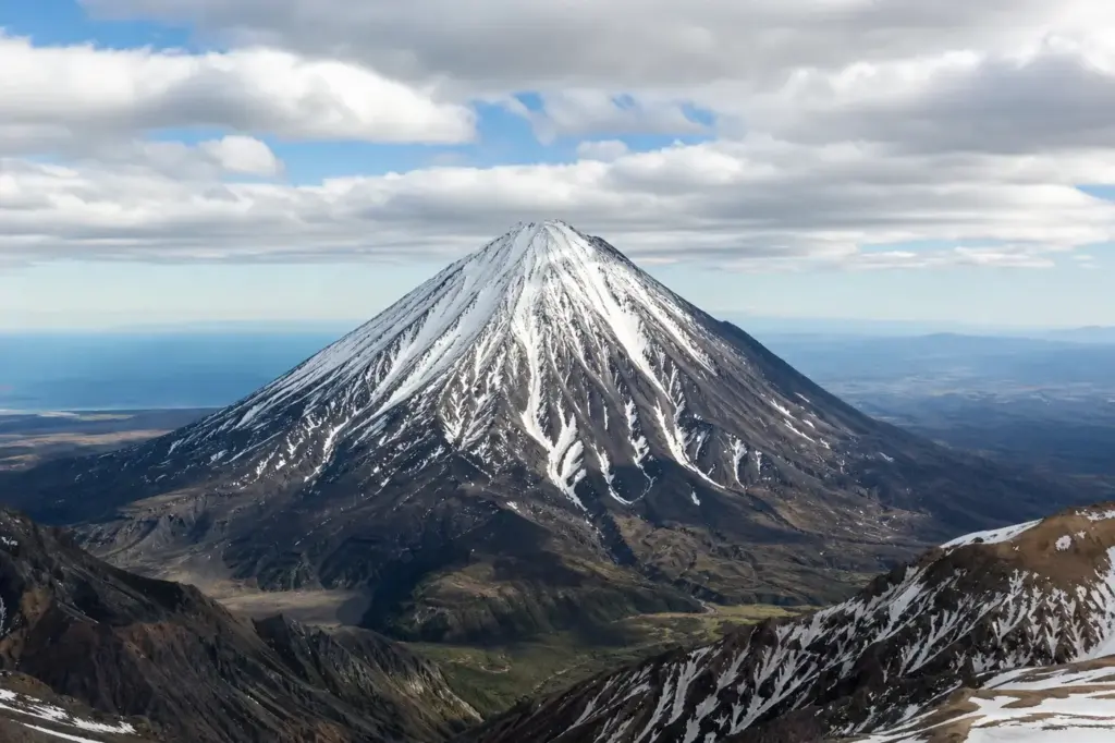
Vilyuchinsky Volcano (also called Vilyuchik) is a steep, deeply gullied stratovolcano south of Avachinsky Bay in Kamchatka, Russia. Rising to 2,173 m, it has lava domes and young basaltic cinder cones around its base. The last significant eruption took place from the summit crater about 10,000 years ago, and the volcano is now dormant, making it safe for visitor access.
Vilyuchinsky volcano is located to the south-west of Petropavlovsk-Kamchatsky, the regional capital, roughly 45 kilometres away across Avacha Bay. This volcano is located within the Volcanoes of Kamchatka, a UNESCO World Heritage property. The volcano attracts visitors year-round: in summer for the waterfall, hot springs, and high-altitude meadows; in winter for skiing and snowboarding.
Quick Facts
| Russian name | Вилючинский вулкан |
|---|---|
| Address | Google MapsApple MapsYandex Maps2GIS |
| District | Yelizovsky |
| Best time to visit | Summer (June–September): Mild temperatures, melting glaciers create the dramatic waterfall, and alpine meadows bloom. The standard season for waterfall hikes and day tours. June and July see the most dependable weather, though afternoon clouds are common. August and September bring cooler temperatures and fewer crowds.Winter (December–February): The volcano becomes a ski and snowboard destination, with the slopes covered in stable snow and views of the frozen landscape. Requires specialized equipment and experience. Days are short; operations often occur during the brief hours of twilight.Shoulder seasons (October–November, March–April): Unpredictable weather, variable snow cover, and limited tour availability make these less reliable for most visitors. |
| Recommended duration | 6–8 hours for the waterfall trek; 10–12 hours for higher elevations |
What Is (and Isn't) Part of a Visit to Vilyuchinsky Volcano, Kamchatka Peninsula?
| Part | Status | Notes |
|---|---|---|
| Vilyuchinsky Volcano cone and summit | Included in the standard ticket | Accessible on established hiking routes; reaching the true summit requires technical climbing skills and is rarely attempted by tourists. |
| Vilyuchinsky Waterfall | Included in the standard ticket | Reached by a dedicated hiking trail on the volcanic slopes; visited as part of standard one-day tours from Petropavlovsk. |
| Vilyuchinsky Pass viewpoint | Included in the standard ticket | A vehicle-accessible overlook with views of the volcano and surrounding peaks; standard stop on tour itineraries. |
| Vilyuchinskye hot springs | Included in the standard ticket | Located at the foot of the volcano near the waterfall; accessible via hiking trail and included in multi-day tours. |
| Zelenoe and Topolovoe lakes | Included in the standard ticket | Glacial lakes formed by ancient lava flows; visited primarily on winter tours with snowmobiles or specialized access. |
| The volcano's interior / crater interior | Not open to visitors | No public access to the crater or interior of the cone; visitors remain on external slopes and established trails. |
| South Kamchatka Nature Park (containing the volcano) | Separate ticket or institution | The volcano is partly situated within this protected park; separate permits may apply for independent backcountry travel. |
Why Visit Vilyuchinsky Volcano, Kamchatka Peninsula?
Vilyuchinsky Waterfall is one of the most visited sights of Kamchatka, a powerful stream that rushes down from 40 metres high, breaks through the glacier and goes several metres deeper. The standard hiking route follows the southwestern slope through cedar dwarf thickets and mountain streams, with an alternation of gray rocky edges and non-melting white snowfields visible on the cone.
To the north of the volcano, slag cones and lava domes reach 25 pieces, and among them you can see Lake Zelenoe, located on the northwestern side, and Lake Topolovoe accessible by snowmobile. In good weather you can see 7 other peaks and the panorama of the mountain valley from the Vilyuchinsky Pass viewpoint.
Highlights of Vilyuchinsky Volcano, Kamchatka Peninsula
The Volcano Cone
Vilyuchinsky is a steep stratovolcano with lava domes and basaltic cinder cones around its base. Its last significant eruption took place about 10,000 years ago, producing an airfall deposit and a lava flow. The cone has a symmetrical profile visible from Petropavlovsk-Kamchatsky across the bay. At its northern slope near the top, there is a small cavity that was a crater destroyed more than 7,000 years ago.
Tip: The volcano's shape is best photographed from the Vilyuchinsky Pass viewpoint or from across Avacha Bay in clear weather.
Vilyuchinsky Waterfall
Vilyuchinsky Waterfall is one of the most visited sights of Kamchatka, a powerful stream that rushes down from 40 metres high, breaks through the glacier and goes several metres deeper. In summer it is pleasantly refreshing with a cloud of fine splashes, and in winter it freezes as a huge icicle. The waterfall emerges from glacial melt fed by the volcano's permanent snowfield.
Tip: The hike to the waterfall takes approximately 4–5 hours from the pass; the fall is most dramatic in early summer when snowmelt is heaviest.
Vilyuchinsky Pass Viewpoint
On the west side of the volcano, there is Vilyuchinsky Pass at 1 km above sea level, a mountain winding road. From this high viewpoint, it offers an excellent view of the slender cone of Vilyuchinsky volcano, and in good weather you can see 7 other peaks and the panorama of the mountain valley.
Tip: This is the standard starting point for volcano tours from Petropavlovsk; the pass is reached by vehicle in approximately 2 hours from the city.
Zelenoe and Topolovoe Lakes
Lava flows 3000–4000 years ago dammed rivers and created Zelenoe and Topolovoe lakes. Lake Zelenoe is located on the northwestern side of the volcano, and Lake Topolovoe is accessible by snowmobile in 15 minutes. The location offers beautiful panoramas and a perfect opportunity for ice fishing.
Tip: These glacial lakes are visited as part of winter tours; in summer, access depends on snow conditions and local guide recommendations.
Cinder Cones and Lava Features
To the north of the volcano, slag cones and lava domes reach about 25 pieces. Lava domes and scoria cones were constructed at its base, with deep erosional valleys visible on the flanks. These young volcanic formations encircle the main cone and show the region's active volcanic past.
Tip: The lava fields are most visible in winter when snow covers vegetation; in summer, guide-led walks explore the landscape in detail.
Hot Springs
Vilyuchinskye hot springs lie at the foot of the volcano near the waterfall. The hot springs are comprised of a variety of small ponds, pools, and tubs, with a small lodge complex built and maintained by a Kamchatka Alpine & Ecological club located nearby. These provide a warm soak after hiking.
Tip: Hot springs are visited as part of day and multi-day tours; bring swimwear if planning to soak.
Winter Skiing and Freeride
Vilyuchinsky is not difficult to climb to a certain height, with the 'commoner' route lying on the south-western slope. For the brave ones, there are great opportunities for a 6-km free-ride down the slope which is 15 to 35 degrees steep. Due to its proximity to Petropavlovsk-Kamchatsky, Vilyuchinsky is popular with skiers and snowboarders.
Tip: Winter access is best from December to March; snow conditions vary, so check with local operators before heading out.
Atmosphere
Vilyuchinsky feels remote yet accessible, a half-day journey from the regional capital. The lower slopes are silent except for the rush of glacial melt and occasional bird calls. At the pass viewpoint, the air is clear and crisp, with a sense of scale as the cone rises steeply before you. In summer, the volcano wears vertical bands of dark gray rock and bright white snow; in winter it becomes monochromatic white except where wind-scoured ridges expose stone. Few other people are visible on most days—the crowds thin quickly above the pass. The atmosphere shifts from forest stillness below to exposed alpine wind above, and visitors feel the isolation of Kamchatka’s southern volcanic landscape.
History of Vilyuchinsky Volcano, Kamchatka Peninsula
Vilyuchinsky is a Pleistocene-to-Holocene stratovolcano, and most of the growth of the volcano took place during the late Pleistocene. Its only recognized eruptive period occurred about 10,000 years ago, when a summit eruption produced airborne volcanic deposits and a lava flow.
Lava flows 3000–4000 years ago dammed local rivers, creating Zelenoe and Topolovoe lakes. These ancient flows shaped the landscape that visitors see today; the lakes serve as markers of past volcanic activity.
Landslides and rock avalanches from the volcano have affected inhabited areas. In 1981 heavy rains from cyclone Elsa caused significant landslides at the volcano. Despite this instability, Vilyuchik is a dormant stratovolcano with no recent or historic eruptions.
The volcano’s name derives from Vilyuchinskaya Bay, which locals called Niyakshin, receiving its modern name in 1830 thanks to local geographers P. Ilyin and P. Skrypov. By the 20th century, the volcano had become a natural monument of Kamchatka and a landmark visible from the regional capital, attracting mountaineers and, later, organized tours.
Legends and Myths about Vilyuchinsky Volcano, Kamchatka Peninsula
The Crater Destroyed by Time
At the northern slope near the top, there is a small cavity that was a crater destroyed more than 7,000 years ago. Local guides tell of how this crater marks the final outburst of the volcano's violent phase, now worn away by millennia of wind, rain, and frost. The scarred summit is a reminder that even the steepest volcanic cones eventually weather into history.
Tickets and Booking for Vilyuchinsky Volcano, Kamchatka Peninsula
Most visitors access Vilyuchinsky Volcano through organized day or multi-day tours departing from Petropavlovsk-Kamchatsky. Tour operators offer both summer (hiking) and winter (skiing) programs. Tours typically include vehicle transport to the Vilyuchinsky Pass (approximately 2 hours from Petropavlovsk), the pass viewpoint visit, and either a waterfall trek or higher-elevation ascent depending on conditions and fitness. Hot springs are often included.
Independent trekking is possible but requires detailed route knowledge and self-sufficiency in a remote area; many areas within the South Kamchatka Nature Park require prior notification. No formal ticket system exists for the volcano itself. Most tours operate June–October (summer hiking) and December–March (winter activities). Check with Petropavlovsk tour operators (found via local hotel concierge or Russian-language travel sites) for current availability, pricing, and departure schedules.
Suggested itineraries Vilyuchinsky Volcano, Kamchatka Peninsula
Half day
Vilyuchinsky Pass viewpoint only. Depart Petropavlovsk early, drive to the pass viewpoint (2 hours each way), spend 30–45 minutes at the overlook, and return to the city. Best for visitors short on time or interested in photography and panoramic views without strenuous hiking.
Full day (summer)
Vilyuchinsky Pass viewpoint, then hike down to Vilyuchinsky Waterfall (4–5 hours). Start early from Petropavlovsk, stop at the pass, then descend the hiking trail through cedar thickets and mountain streams to reach the waterfall. Soak at the nearby hot springs if conditions allow. Return to Petropavlovsk by evening.
Full day (winter)
Vilyuchinsky Pass viewpoint and skiing or snowboarding descent (6–8 hours total). Drive to the pass, explore the panorama, then ski or snowboard the southwestern slope (approximately 6 km descent at 15–35 degrees). Requires intermediate skiing skills and avalanche awareness. Guides and avalanche equipment recommended.
2–3 days
Extended hiking or camping trek including the waterfall, hot springs, and higher elevations. Day 1: hike to hot springs and camp. Day 2: explore glacier features and higher slopes or ski descent in winter. Day 3: return via the pass viewpoint to Petropavlovsk. Suitable for experienced backpackers with camping gear and mountaineering skills.
How to Get to Vilyuchinsky Volcano, Kamchatka Peninsula
From Petropavlovsk-Kamchatsky: All visitors travel via Petropavlovsk, the regional capital, located across Avacha Bay. There are no direct public transport links to the volcano; access is exclusively by private vehicle or organized tour.
By organized tour: Most visitors book day or multi-day tours through operators in Petropavlovsk. Tours include pick-up from central hotels (typically 7–8 a.m. departure), a drive south and west of the city (approximately 45–90 minutes depending on route conditions), and drop-off back at the hotel by early evening for day trips. Tours provide transport to Vilyuchinsky Pass and the trailheads.
By private vehicle or taxi: Experienced drivers comfortable with rough roads may self-drive; routes follow a mix of asphalt and unpaved volcanic terrain. Vehicle hire in Petropavlovsk is available but expensive. A local guide is recommended for independent travel.
Hiking start point: Most trails begin at or below Vilyuchinsky Pass (1,000 m elevation), reached by vehicle. The Vilyuchinsky Waterfall hike starts from the pass and descends roughly 600 metres over 4–5 hours one way.
Accessibility
The Vilyuchinsky Pass viewpoint is accessible by vehicle and requires no strenuous hiking—suitable for visitors with limited mobility. The parking area and information stands allow viewing and photography without exertion. Hiking to the waterfall involves uneven mountain terrain, streams, and sustained elevation gain over 4–5 hours; not suitable for those with mobility, balance, or cardio limitations. The trail has no steps or formal infrastructure. Winter access (skiing) is not wheelchair accessible. No wheelchair-accessible restrooms or facilities exist at the trailheads or pass viewpoint.
Food Nearby
No restaurants or food services exist at the volcano or pass viewpoint. Day tours from Petropavlovsk include packed lunches or arrange meals in the city before departure. Multi-day camping trips require visitors to bring all food. Petropavlovsk (45 km north) has restaurants and shops; buy supplies before heading to the volcano.
What to Bring
Waterproof hiking boots with ankle support (muddy streams and loose volcanic rock); layers (wind and cold at elevation even in summer); sun protection (strong UV exposure at altitude and reflection from snow); high-calorie snacks and 2–3 litres of water for day hikes. Winter trips require ski or snowboard equipment, avalanche beacon, probe, shovel, and professional guide. No special permit is required for day visits to the volcano or pass viewpoint.
Best Views and Photo Spots of Vilyuchinsky Volcano, Kamchatka Peninsula
Vilyuchinsky Pass overlook
The cone of Vilyuchinsky fills most of the frame with its steep snow-covered north face and dark volcanic ridges. In good weather you can see 7 other peaks and the panorama of the mountain valley extending behind and around the volcano.
Best time: Early morning or late afternoon for slanting light on the cone; clear days after weather fronts pass, typically May–August
Vilyuchinsky Waterfall vista
The waterfall cascades over a glacier in a narrow ravine, framed by cedar thickets below and snow-clad slopes above. In summer it is pleasantly refreshing with a cloud of fine splashes, and in winter it freezes as a huge icicle.
Best time: Early summer (June–July) for water flow; January–February for frozen formations; overcast days reduce glare and reveal water texture
Avacha Bay view toward the volcano
The volcano is dazzlingly white in winter and beautiful in summer, with a smooth cone that from a distance looks polished. The bay stretches below with Petropavlovsk visible across the water.
Best time: From Petropavlovsk waterfront or boat tours in bay; early morning or sunset for warm light; cleared weather days in summer or winter
Crater cavity on northern slope
A small eroded depression visible with binoculars or telephoto lens from the pass viewpoint or mid-trail, marking the remains of the last active crater.
Best time: Clear weather with strong light to reveal shadow and texture on the north-facing slope; telephoto lens recommended
Cinder cones and lava fields to the north
Slag cones and lava domes reach about 25 pieces in a pattern of small dark peaks and ridges against white snow or green tundra, showing the region's complex volcanic history.
Best time: Winter for stark contrast between dark lava and white snow; autumn morning light highlights texture
Photography Rules
Climbing or close approach requires preparation for steep terrain, weather, and wildlife. No restrictions on photography from the pass viewpoint or trails. Drones are not permitted in South Kamchatka Nature Park; check with local authorities before flying. Tripods are not restricted. The waterfall and surrounding glacier are photogenic in both summer (with flowing water and green tundra) and winter (frozen formations and snow).
Family Suitability
The Vilyuchinsky Pass viewpoint visit is family-friendly: a short drive and walk to overlooks with no strenuous hiking required. Children aged 8 and older with reasonable fitness can enjoy the views and short walks. The waterfall hike (4–5 hours with elevation gain) is suitable for active children aged 10+ with hiking experience; younger children may find the duration and uneven terrain challenging. Winter skiing requires appropriate skills and equipment. No strollers can be used on mountain terrain. Organized family tours with professional guides are recommended for visitors with young children.
Russia Vibes Tips
- Book tours at least 2–3 days in advance through Petropavlovsk hotels or tour operators; availability varies by season and weather. Cancellations happen often in shoulder seasons due to poor conditions.
- Bring sun protection even on cloudy days: UV exposure is intense at altitude. High-SPF sunscreen, sunglasses, and a hat are essential.
- Water on the trail comes from glacial melt and mountain springs—generally safe to drink, but test first or carry purification tablets to be certain.
- The 'seven peaks' visible from the pass in good weather include nearby volcanoes Mutnovsky and Gorely; a local guide can identify them by direction and name them.
- Do not attempt the summit without climbing experience and technical gear; the cone steepens dramatically above 1,500 metres, and loose volcanic rock is unstable.
- Weather changes rapidly: bring waterproof layers even on clear-sky mornings. Clouds and wind can roll in within an hour, reducing visibility.
Explore Nearby Vilyuchinsky Volcano, Kamchatka Peninsula
Browse more: More in Yelizovsky · All Kamchatka Peninsula · All Landmarks · All Sightseeing · All Sightseeing in Kamchatka Peninsula
FAQ: Vilyuchinsky Volcano, Kamchatka Peninsula
Is Vilyuchinsky Volcano active and dangerous?
Vilyuchik is a dormant stratovolcano with no recent or historic eruptions. Hazards are minimal but include potential future explosive activity and lahars from heavy rains or snowmelt. No current volcanic alerts apply. Visitors can safely hike the trails.
Can I climb to the summit?
It is not difficult to ascend Vilyuchinsky to a certain height, but ascent to the summit is possible only for people with climbing skills. Most day tours reach 1,500–1,800 metres; technical climbing skills, ice axes, and ropes are needed for the final cone.
How long is the hike to the waterfall?
The hike from Vilyuchinsky Pass to the waterfall takes 4–5 hours one way over terrain with continuous elevation loss of roughly 600 metres. The return hike is more strenuous due to the climb back up.
What is the best season to visit?
Summer (June–September) is the standard season for waterfall hikes and day tours, with mild weather and the waterfall flowing dramatically. Winter (December–February) attracts skiers and snowboarders but requires experience and specialized equipment.
Do I need a permit or guide?
No formal permit is required for day visits to the volcano or pass viewpoint via organized tours. Independent backcountry camping within South Kamchatka Nature Park may require advance notification. A local guide is strongly recommended for independent hiking.
Are there hot springs near the volcano?
Vilyuchinskye hot springs are comprised of a variety of small ponds, pools, and tubs, with a small lodge complex built and maintained by a Kamchatka Alpine & Ecological club located nearby. They are included in many multi-day tours.
How far is the volcano from Petropavlovsk-Kamchatsky?
Vilyuchik rises prominently about 45 km SW of Petropavlovsk-Kamchatsky. Vehicle travel from the city to the pass typically takes 2 hours over mixed asphalt and rough terrain.
What about the lakes Zelenoe and Topolovoe?
Lava flows 3000–4000 years ago dammed rivers and formed Zelenoe and Topolovoe lakes. These are visited mainly on winter tours with snowmobiles; summer access depends on snow conditions and depends on guide availability.
Russia Vibes is a one-person project. A coffee keeps it going

Take this guide with you
Get a free PDF of this guide to print or read offline: key facts, tips and a map link on a few clean pages.
Report an issue on this page
Paying for your trip: please read
Payments and bookings between Russia and many other countries are currently restricted. In practice, cards issued in the EU, the UK, the US and several other countries often cannot be used in Russia, Russian cards usually cannot be used abroad, and some booking platforms, airlines and payment providers limit or pause their services for Russia. The situation changes frequently.
We do not give legal or financial advice, and this site does not encourage anyone to break any rule that applies to them. Whatever you plan, you are responsible for following the laws and regulations that apply to you, including those of your country of residence and citizenship.
Many travelers still organise their stay without problems. It is worth asking your bank or payment provider what is currently possible, contacting hotels, tour operators and carriers directly about the payment methods they accept, and checking which services are open to customers from your country. Clarify payment, cancellation and refund terms before you commit to a booking, and keep your plans flexible.
Partner links on this site may not be available in every country, and prices, availability and rules in our guides can differ from what you see when you book.
How we research and update our guides
About this guide: AI assistance and accuracy
This guide is created with the help of AI and is based on official sources where available. Mistakes can still happen. Opening hours, prices, rules and other details are given to the best of our knowledge as of the date shown and can change without notice. It offers general recommendations only, not professional, legal or travel advice. Please confirm important details with the official source before you travel; you are responsible for your own plans and decisions.
* Affiliate link: as an Amazon Associate we earn from qualifying purchases at no extra cost to you.