
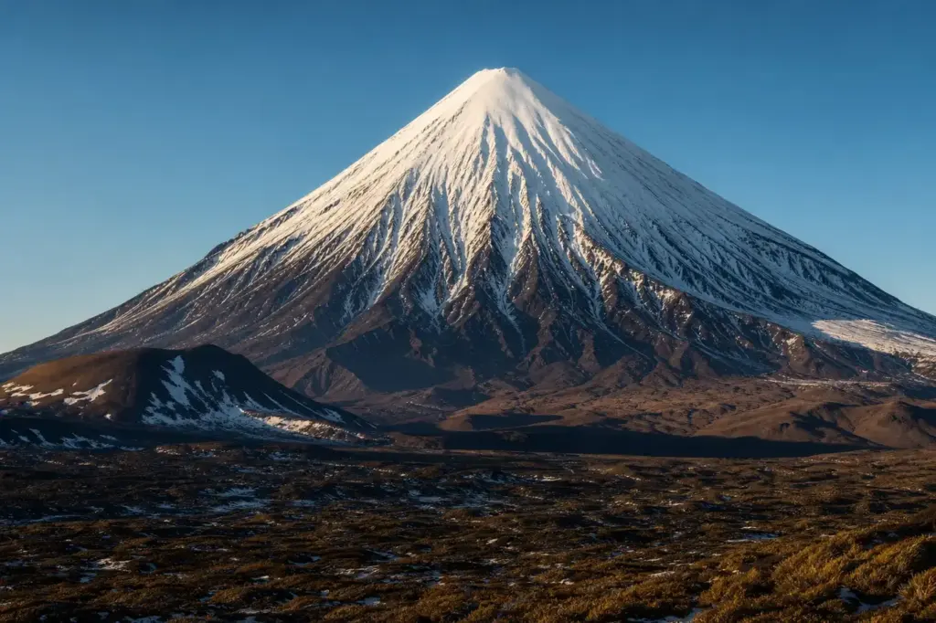
Koryaksky volcano is one of Kamchatka‘s most iconic peaks, a symmetrical stratovolcano rising 3,456 meters above the landscape. Located about 30 km northwest of Petropavlovsk-Kamchatsky, this active volcano dominates the southern Kamchatka horizon and is one of the region’s five so-called “domestic volcanoes”—mountains so prominent they are visible from the city.
The volcano sits within the Avachinskaya group and is part of the Volcanoes of Kamchatka UNESCO World Heritage property. It is designated a Decade Volcano, recognized for its history of explosive eruptions and proximity to populated areas.
Quick Facts
| Russian name | Коря́кская со́пка |
|---|---|
| Address | Kamchatka Peninsula, near Petropavlovsk-Kamchatsky Google MapsApple MapsYandex Maps2GIS |
| District | Kamchatka Krai |
| Best time to visit | Late summer and early autumn (August–September) offer the most stable climbing conditions, with established routes and predictable weather patterns. Spring (May–June) can be feasible but risks avalanches from heavy snowfall. Winter (December–February) is possible but extremely harsh; snow accumulation makes travel difficult unless arranged via snowmobile.For casual viewing from the mountain pass, any season works, but spring and summer (May–September) offer the clearest visibility and most reliable road access. September–October features crisp air and excellent light for photography. |
| Recommended duration | 4–8 days (summit climb); 2–4 hours (viewpoint) |
What Is (and Isn't) Part of a Visit to Koryaksky Volcano, Kamchatka Peninsula?
| Part | Status | Notes |
|---|---|---|
| Summit climb (3,456 m) | Included in the standard ticket | Accessible only to experienced mountaineers; requires special permits and mountaineering equipment (crampons, ice axe, ropes). |
| Mountain pass viewpoint (accessible by vehicle from Elizovo) | Included in the standard ticket | A roadside plateau and natural parking area offering close views; accessible to all visitors without special skills. |
| Camel Hill elevated viewpoint | Included in the standard ticket | A 3 km hike from the main viewpoint for an elevated perspective; moderate difficulty, no technical climbing required. |
| Lower slope hiking and circumnavigation | Included in the standard ticket | Multi-day treks around the volcano's lower slopes through Nalychevo National Park and reserve areas; requires permits and local guidance. |
| Avacha Bay boat tours (volcano views from water) | Separate ticket or institution | Separate boat tours from Petropavlovsk-Kamchatsky offer distant ocean-level views; not part of climbing or land-based access. |
| Avachinskaya Volcano (neighboring cone) | Outside / not part of it | A separate active volcano 10 km away; sometimes included in multi-day trekking routes but is a distinct peak. |
Why Visit Koryaksky Volcano, Kamchatka Peninsula?
Koryaksky offers both accessible viewpoints and serious mountaineering. Non-climbers can visit roadside viewpoints or photograph the snow-capped cone from Avacha Bay by boat. The mountain’s steep slopes attract experienced climbers seeking a multi-day technical challenge requiring ice climbing skills and crampons.
The volcano’s striking symmetry and glaciated slopes make it one of Kamchatka’s most photographed peaks, visible even from city streets. For those interested in volcanology, the active fumaroles on the northwest flank and the recent 2008–09 fumarolic activity demonstrate ongoing geothermal processes.
Highlights of Koryaksky Volcano, Kamchatka Peninsula
The Summit Cone and Western Crater
The upper cone rises steeply to 3,456 meters, with slopes reaching 35 degrees at the peak. A crater sits in the western part of the summit ridge, measuring 180–200 meters across with walls 20–30 meters high and breached to the south. The crater is glacier-covered, creating a striking white dome visible from the city.
Tip: The summit is only accessible to experienced mountaineers with proper permits and equipment; most visitors admire the peak from lower viewpoints.
Northern Summit Glaciers
Two large glaciers descend from a 500-meter-diameter cirque on the northern summit. These snow fields characterize the volcano's upper slopes and make the peak visually distinctive, especially in clear weather. The glaciers are approximately 4.2 kilometers and 1 kilometer in length.
Tip: Glacier crossings require mountaineering experience and awareness of crevasse hazards; avalanche risk increases with heavy snowfall.
Radial Ravines and Deep Gullies
The cone is grooved by deep radial ravines cut by water flowing to the base, creating a ribbed pattern especially prominent on the eastern flanks. These gullies, sometimes snow-filled, define the mountain's distinctive profile and add to the climbing difficulty by breaking the slope into sections.
Tip: These ravines are visible even from the city and offer variation in climbing terrain; different routes use different gullies.
Active Fumaroles on the Northwest Slope
Gas vents are located on the northwest flank at approximately 3,000 meters elevation, with the main jets discharging from a fissure formed during the 1957 phreatic eruption. Low-temperature fumaroles also exist in the glacier-covered summit crater, demonstrating the volcano's ongoing geothermal activity.
Tip: Approach fumarole areas with caution; volcanic gases pose a health risk near vents. Check current volcanic alerts before approaching.
The 1895 Eruption Lava Flows
The first recorded historical eruption occurred in 1895 and produced a lava flow, one of the few major eruptions in the volcano's documented history. Most recent activity has been limited to phreatic and fumarolic events rather than major magmatic eruptions.
Tip: Lower western and southeastern flanks show evidence of this historical activity; these slopes remain steep and unstable for climbing.
Viewpoint Access from Elizovo Road
A road from Elizovo (near Petropavlovsk-Kamchatsky) leads to a mountain pass and natural plateau that serves as a popular viewpoint and parking area. The terrain offers clear views of the snow-covered cone and surrounding volcanic landscape. Some visitors hike further to Camel Hill for elevated views.
Tip: This viewpoint is accessible by regular vehicles and offers the most practical way for non-mountaineers to see the volcano up close; plan a 1–2 hour drive from the city.
Atmosphere
Koryaksky presents a stark, dramatic presence—a perfectly proportioned cone of white snow and dark volcanic rock dominating the landscape. In clear weather, the summit is sharply defined; in clouds, the peak vanishes and reappears mysteriously. The slopes are silent and exposed, carved by wind and snow.
From the city, the volcano is an omnipresent backdrop, a constant reminder of Kamchatka’s volcanic nature. At the base, hardy tundra and low vegetation create a sparse, uncluttered environment. In climbing season (late spring and early autumn), mountaineers arrive in small numbers. Most casual visitors encounter the volcano from a distance—from viewpoints, from the city, or reflected in Avacha Bay.
History of Koryaksky Volcano, Kamchatka Peninsula
Koryaksky sits on the Pacific Ring of Fire at the subduction boundary where the Pacific Plate slides beneath the Eurasian Plate at roughly 80 millimeters per year. Its stratovolcano structure—alternating layers of lava, ash, and ejected rock—accumulated over geologic time.
The volcano’s name derives from the Koryak people, Indigenous inhabitants of Kamchatka. In the 19th century, nomadic Koryak herders with reindeer established settlements at the volcano’s foot, and locals named the peak “Koryaksky” in their honor. The mountain became known as one of Kamchatka’s five “domestic volcanoes,” volcanoes so dominant and close that residents consider them part of the city.
The first recorded historical eruption occurred in 1895, producing a lava flow. Unlike many Kamchatkan volcanoes, Koryaksky has not experienced major magmatic eruptions in recorded history. Activity in 1956–57 involved a phreatic (steam-driven) eruption with a fissure forming on the northwest slope, ejecting gas and ash. A fissure 400–500 meters long opened at 3,000–3,100 meters elevation, with emissions reaching 350 meters high and traveling at 150 meters per second; ashfall was reported 18 kilometers away.
The most recent volcanic event occurred in 2008–09, when the volcano again displayed fumarolic and ash activity. Gas emissions continued for months, and minor ash plumes rose to approximately 4,000–6,000 meters. Throughout these episodes, the volcano caused no catastrophic damage but serves as a reminder of its volatile nature. In 1996, Koryaksky was designated a Decade Volcano by the United Nations, recognized as worthy of particular study due to its proximity to Petropavlovsk-Kamchatsky and its potential for explosive eruptions.
Legends and Myths about Koryaksky Volcano, Kamchatka Peninsula
The Koryak Guardian
Legend – historically unreliable. Local legend holds that the volcano and its neighbor Avachinsky are guardians of Kamchatka. The Koryak people believed the mountain contained spiritual forces and treated it with reverence. Some folklore suggests the snow-capped peak was a blessing to the region, while its eruptions represented the earth's anger.
Tickets and Booking for Koryaksky Volcano, Kamchatka Peninsula
Climbing Koryaksky requires a special permit from the Nalychevo National Park administration. Tourists must also register with local authorities (OVIR) within three days of arrival and obtain a border-zone permit. Most visitors arrange permits through local Kamchatka travel agencies or tour operators.
Access to the mountain pass viewpoint by car is unrestricted and free. Multi-day treks require park permits, typically arranged by guiding companies. Russian visa and registration rules apply to all foreign visitors. Check with the Kamchatka Volcanoes park administration or local guides for current permit requirements, as regulations may change.
Suggested itineraries Koryaksky Volcano, Kamchatka Peninsula
2–4 hours
Drive from Petropavlovsk-Kamchatsky to the mountain pass viewpoint (about 50 minutes each way). Stop at the natural plateau for photographs and observation of the snow-capped peak. Hike to nearby Camel Hill if time and fitness permit. Return to the city by late afternoon.
Half day
Depart early for the viewpoint to catch morning light on the peak. Spend 2–3 hours observing and photographing from multiple angles. Option to take a guided walk around the lower base of the volcano if weather permits. Return to the city for dinner.
4–8 days
Summit expedition (mountaineering only). Depart from Petropavlovsk-Kamchatsky with an experienced local guide. Day 1–2: Approach march to base camp. Day 3–4: Acclimatization and equipment checks. Day 5: Summit push using crampons and ice axe, aiming for the crater. Day 6–7: Descent and return. Requires advanced mountaineering skills and prior alpine experience.
Multi-day trek
Circumnavigate the volcano's lower slopes through Nalychevo National Park with a guide. Visit multiple viewpoints, observe radial ravines and lower geology, and camp near base areas. Suitable for strong hikers without full mountaineering training. Permits required.
How to Get to Koryaksky Volcano, Kamchatka Peninsula
By road from Petropavlovsk-Kamchatsky: The nearest viewpoint and mountain pass are accessible by road. A taxi or private car will take about 50 minutes (roughly 30 km) from the city. The road is rough in places, particularly beyond the main pass.
Viewpoint access: A fairly well-established track leads to a natural plateau and parking area; most vehicles can reach this point. Beyond this point, 4WD vehicles or hiking is necessary.
Base camp approach: For climbing expeditions, travel to Elizovo (near Petropavlovsk-Kamchatsky airport), then arrange transport to the start of climbing routes. Local guides can organize 4WD transport to the base camp area or arrange snowmobile access in winter and spring.
Permits: All climbers must obtain permits in advance through the Nalychevo National Park office or via registered tour operators. Foreign visitors require Russian visa, OVIR registration, and border-zone authorization.
Accessibility
The mountain pass viewpoint and parking area are accessible to most visitors; roads are rough but passable by standard vehicle. No formal accessibility facilities exist. Those with mobility limitations can view the volcano from the parking plateau without significant physical exertion.The summit climb is not wheelchair accessible and requires advanced mountaineering skills. Lower slope walking and circumnavigation treks are suitable only for those with good fitness and hiking experience. Park authorities do not routinely provide specific accessibility information, so travelers with particular needs should contact local guides or the Nalychevo National Park office in advance.
Food Nearby
Basic supplies are available in Elizovo (near the airport, about 45 km from the mountain pass viewpoint). Petropavlovsk-Kamchatsky (30 km away) has restaurants, cafes, and markets with fresh and packaged food. For summit expeditions, mountaineers should bring all food and water from the city, as no services exist on or near the volcano. Local guides can advise on supply caching and cooking at base camps.
What to Bring
For viewpoint visits: sturdy shoes or boots, layers, wind-resistant jacket (weather is unpredictable), sunscreen, water, and a hat. The plateau is exposed and windy; bring protection against sun and cold.For climbing: mountaineering boots, crampons, ice axe, ropes, harness, belay devices, helmet, high-altitude sleeping bag, stove and fuel, food and water, map, compass, first aid kit, emergency whistle, and insect repellent for lower elevations. Weather and avalanche risk demand constant awareness; do not climb without experienced local guides. No bag restrictions; standard security screening does not apply.
Best Views and Photo Spots of Koryaksky Volcano, Kamchatka Peninsula
Mountain pass viewpoint plateau
Frontal view of the snow-covered cone from close range; the radial ravines and glaciated slopes are clearly visible. The natural plateau provides a stable platform for steady photos. In clear conditions, the entire upper mountain is framed against sky.
Best time: Early morning (sunrise light), or golden hour near sunset. September–October offer clearest visibility. Avoid mid-day glare and cloud cover.
Camel Hill (3 km from main viewpoint)
An elevated vantage point offering a slightly higher perspective. The cone is visible in fuller profile; surrounding landscape and neighboring peaks appear more clearly. Excellent for wide-angle landscape shots.
Best time: Late afternoon when the peak is well-lit. Weather-dependent; strong winds common at elevation. Best in settled weather patterns.
Road approach descent (between Elizovo and viewpoint)
As you approach from the city, the volcano grows larger with each switchback. Multiple pullouts offer frames of the peak with road context or distant views with broader landscape. Roadside perspectives change with angle and elevation.
Best time: Any clear day; morning light favorable. Drive multiple times to capture different angles and light.
Avacha Bay (by boat)
Ocean-level perspective with the cone rising above water; unique angle unavailable from land. Glaciers and upper cone are silhouetted against sky. Avacha Bay often catches dramatic lighting from the west.
Best time: Boat tours typically depart mornings; afternoon sea state can be rough, limiting visibility. Check tide and weather before scheduling boat tours.
Photography Rules
Photography is unrestricted at viewpoints. Drones require special authorization from local park authorities; check regulations before use. Tripods are permitted at the plateau viewpoint. Flash is unnecessary outdoors. The peak is often photographed at sunrise or sunset for dramatic light; clouds frequently obscure the summit mid-morning and afternoon.
Family Suitability
The mountain pass viewpoint is suitable for families with children of any age who can walk short distances. The plateau is exposed and windy; keep young children close and monitor carefully. Camel Hill is a 3 km moderate hike and suitable for children ages 8–10 and older with hiking experience.Full summit climbing is only for experienced mountaineers and not suitable for families with children. Multi-day lower-slope treks through Nalychevo National Park can be adapted for strong teen hikers with local guides; families should discuss fitness and experience with guides beforehand. Stroller access to the plateau is not practical; paths are rough terrain.
Russia Vibes Tips
- The volcano is visible from Petropavlovsk-Kamchatsky on clear days; check local weather before driving to the viewpoint, as cloud cover frequently obscures the summit mid-day. Early morning usually offers the clearest views.
- Many visitors end their visit at the main plateau viewpoint. If you have fitness and time, the 3 km hike to Camel Hill offers a significantly different perspective and fewer crowds.
- Permits for climbing must be arranged well in advance through local travel agencies; do not attempt to climb without proper authorization. The mountain is actively monitored by volcanologists, and access is restricted during periods of elevated seismic or fumarolic activity.
- The road to the viewpoint is rough and can be impassable after heavy rain or during snowmelt. Inquire locally or with your hotel about current road conditions before driving.
- Avalanche risk is significant on steep slopes during and after heavy snowfall. Do not venture onto untracked snow slopes without a guide familiar with current conditions. Always check volcanic alert status with KVERT (Kamchatka Volcanic Eruption Response Team) before climbing.
- The plateau parking area is the endpoint for most casual visitors but also serves as a picnic and rest area for longer expeditions. Facilities are minimal; bring water and snacks.
Explore Nearby Koryaksky Volcano, Kamchatka Peninsula
Browse more: More in Kamchatka Krai · All Kamchatka Peninsula · All Landmarks · All Sightseeing · All Sightseeing in Kamchatka Peninsula
FAQ: Koryaksky Volcano, Kamchatka Peninsula
Can you climb Koryaksky without mountaineering experience?
No. The summit requires technical mountaineering skills, crampons, ice axes, and ropes. Loose rock, steep ice-covered slopes (30–35 degrees at the peak), crevasses, and avalanche hazards make this a serious undertaking. Only experienced alpinists should attempt the summit; all climbers must hire local guides and obtain permits.
Is there an easy way to see Koryaksky without climbing?
Yes. The mountain pass viewpoint (accessible by car, roughly 50 minutes from Petropavlovsk-Kamchatsky) offers close views of the snow-capped cone without technical climbing. A 3 km moderate hike to Camel Hill provides an elevated perspective. Boat tours from Avacha Bay also offer distant ocean-level views of the volcano.
How long does it take to climb Koryaksky?
Summit expeditions typically take 4–8 days from Petropavlovsk-Kamchatsky, including approach march, acclimatization, summit push, and descent. The climb itself (from base camp to summit) takes 6–10 hours depending on conditions. Speed depends on fitness, weather, and snow conditions.
What permits do climbers need?
Foreign climbers must obtain a Russian visa, register with local OVIR authorities within three days of arrival, acquire a Nalychevo National Park climbing permit, and obtain border-zone authorization (as the volcano is near sensitive areas). Most climbers arrange permits through Kamchatka-based travel agencies or guiding companies.
When is the best season to climb?
Late summer and early autumn (August–September) offer the most stable conditions with established routes and predictable weather. Spring (May–June) can work but carries higher avalanche risk. Winter is technically possible but extremely harsh; snowmobiles may be necessary.
How close is Koryaksky to Petropavlovsk-Kamchatsky?
The volcano is approximately 30 km northwest of the city and is visible from streets on clear days. The mountain pass viewpoint is about 50 minutes' drive from the city center. The volcano is considered one of Kamchatka's five "domestic volcanoes" because of its proximity and prominence.
Is Koryaksky an active volcano? Is it safe?
Yes, Koryaksky is officially classified as active. Its last eruption was in 2008–09, featuring fumarolic and minor ash activity. The volcano is monitored by the Kamchatka Volcanic Eruption Response Team (KVERT). Climbers must check current volcanic alerts before ascending. Hazards include avalanches, crevasses, volcanic gases near fumaroles, and potential ashfall, but eruptions have been infrequent in recorded history.
What is the crater like?
The summit crater is located in the western part of the ridge, measuring 180–200 meters in diameter with walls 20–30 meters high. It is breached to the south and glacier-covered. The crater hosts low-temperature fumaroles (gas vents), evidence of ongoing geothermal activity. Only climbers who reach the summit can see the crater directly.
Russia Vibes is a one-person project. A coffee keeps it going

Take this guide with you
Get a free PDF of this guide to print or read offline: key facts, tips and a map link on a few clean pages.
Report an issue on this page
Paying for your trip: please read
Payments and bookings between Russia and many other countries are currently restricted. In practice, cards issued in the EU, the UK, the US and several other countries often cannot be used in Russia, Russian cards usually cannot be used abroad, and some booking platforms, airlines and payment providers limit or pause their services for Russia. The situation changes frequently.
We do not give legal or financial advice, and this site does not encourage anyone to break any rule that applies to them. Whatever you plan, you are responsible for following the laws and regulations that apply to you, including those of your country of residence and citizenship.
Many travelers still organise their stay without problems. It is worth asking your bank or payment provider what is currently possible, contacting hotels, tour operators and carriers directly about the payment methods they accept, and checking which services are open to customers from your country. Clarify payment, cancellation and refund terms before you commit to a booking, and keep your plans flexible.
Partner links on this site may not be available in every country, and prices, availability and rules in our guides can differ from what you see when you book.
How we research and update our guides
About this guide: AI assistance and accuracy
This guide is created with the help of AI and is based on official sources where available. Mistakes can still happen. Opening hours, prices, rules and other details are given to the best of our knowledge as of the date shown and can change without notice. It offers general recommendations only, not professional, legal or travel advice. Please confirm important details with the official source before you travel; you are responsible for your own plans and decisions.
* Affiliate link: as an Amazon Associate we earn from qualifying purchases at no extra cost to you.